


A Summary of Several Theories of Book of Mormon Lands in Mesoamerica
A Summary of Several Theories of Book of Mormon Lands in Mesoamerica
by
Materials, concepts, maps or conclusions presented at our forums or appearing on this website or
emailed to BMAF members and guests is the sole responsibility of the contribiuting author(s) and does
not necessarily imply that members of the Board of Directors or members of BMAF agree with all or
any part of the subject matter and is not sponsored in any way by the Church of Jesus Christ of Latter-day Saints
The purpose of this article is to acquaint the reader with current proposals of
where the Book of Mormon took place in Mesoamerica
1. High Civilization with Kings and Priests and City-States — (Mos. 1:1-7; 2:8; 6:3; 29:25; Al. 4:16-17; 30:29;
43:23; 50:13-15; 51:7, 15-16, 26; Hel. 6:13)
2. Agricultural Base to Support Several Millions of People —(Al. 3:2; 4:2; Hel. 6:12; 3 Nep. 4:4)
3. Highly Literate Society (Written Language) with Scribes as Important Officers — (Mos. 1:1-7;
Al. 60:1-36; 63:11-13; Moroni 1:1; 8:1; 9:1)
4. Multiple, Functional Calendar and Dating Systems — (Al. 51:37-52:1; Hel. 6:14-16; 3 Nep. 2:8)
5. Merchant Class Using Weights and Measures — (Hel. 6:8-9; 7:21; Al. 11:4-19; Ether 10:22)
6. Engineers to Build Temples, Towers, and Highways using Cement — (2 Nep.5:16; Mos. 2:1, 7; 19:5-6;
Hel. 3:7-11; 14:24; 3 Nep. 6:8; 8:13)
7. Highly-skilled Craftsmen—Precious Metals, Stonework — (Jar. 1:8; Omni 1:20; Hel. 6:11; Ether 10:27)
8. Warrior Society, Great Battles, Structured Armies, Sophisticated Fortifications — (Alma 49:18-23;
50:1-10; 51:22-37; 53:3-5)
9. Tribal Marriage Alliances — (Alma 17:24; 47:35)
10. Enduring Legends of White, Bearded God — (3 Nephi 11:8-14)
All of the above criteria must be found in a place marked by a Narrow Neck of Land — (Alma 22:32) and a
Major River flowing from South to North — (Al. 16:6-7; 22:27; 50:11). Additionally, these criteria must be
found in the Western Hemisphere where Joseph Smith could not have known about them in 1829.

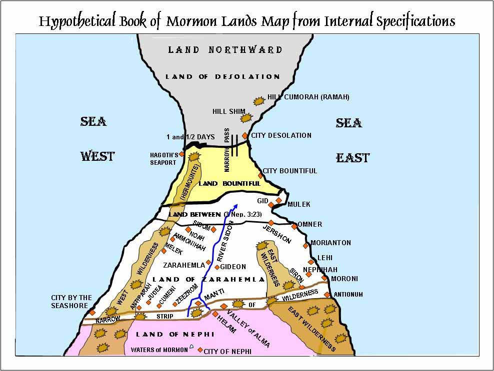
The Book of Mormon does not state into which sea the River Sidon empties, so the mouth of the river is not shown.             (See Alma 22:32 and Helaman 3:8)  Note that neither passage states that the piece of territory mentioned extends from the sea West to the seat East, only from the sea West to an unspecified place a relatively short distance to the east.  The line
between the lands Bountiful and Desolation was a position that required specific fortifications, not that the fortifications ran
all the way from the sea West to the sea East.  There is nowhere in Mesoamerica or Central America (including the
Isthmus of Panama), where a person could have traveled from ocean to ocean, through dense jungles and over mountains,   in one to one and one-half days.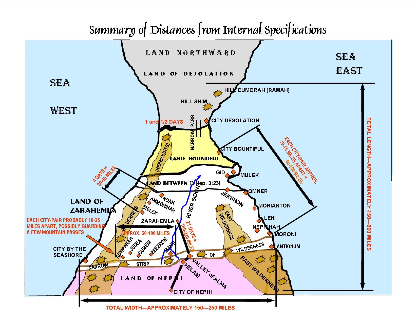
Distances in the Book of Mormon are not given in units of linear measurement but in units of time taken to travel from one place to another. These approximations assume distance traveled in one day to be about 6-8 miles.
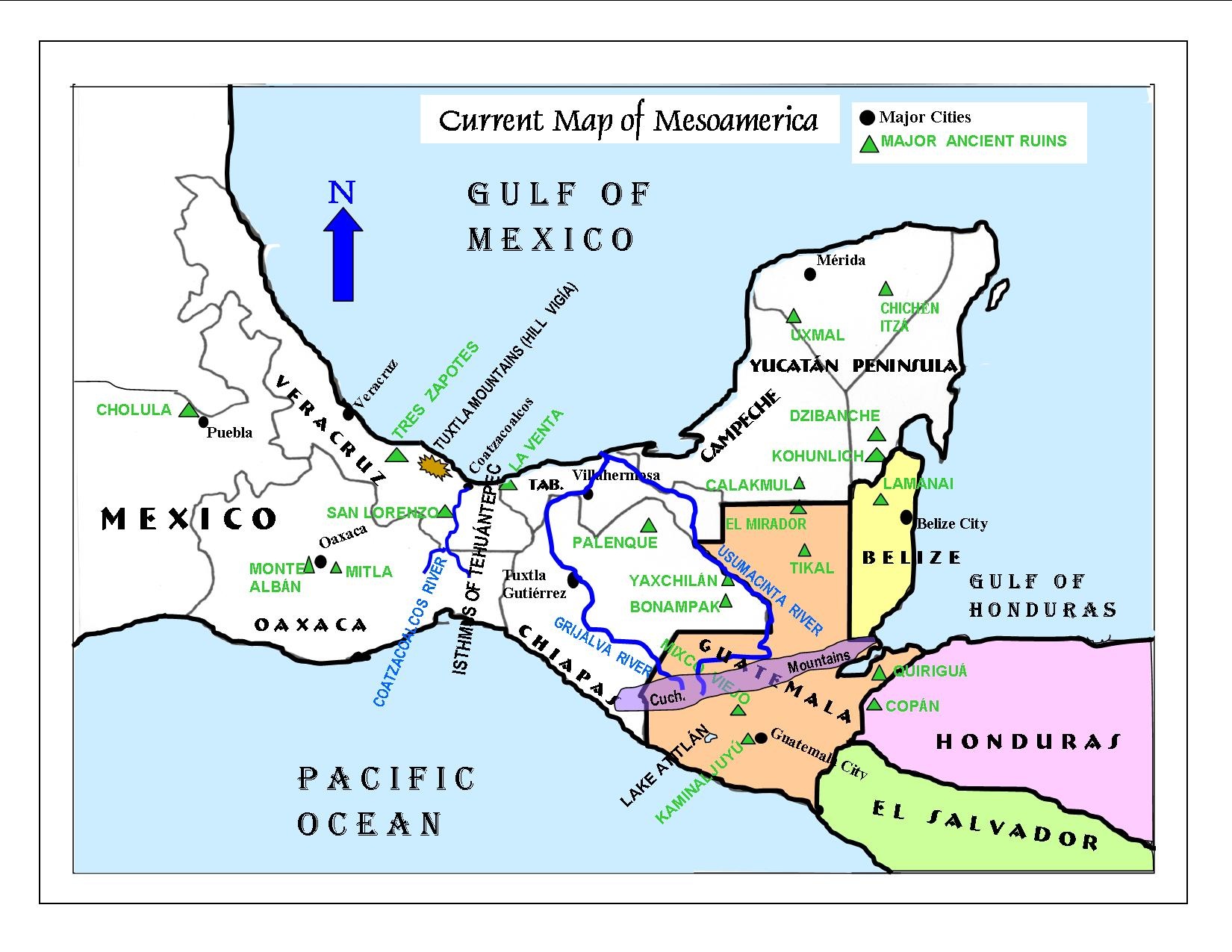
Google Earth Map of Mesoamerica
September 15, 1842, page 914)
“The city of Zarahemla, burnt at the crucifixion of the Savior, and rebuilt afterwards, stood upon this land . . . .”
“. . . the ruins of Zarahemla have been found where the Nephites left them . . . .”
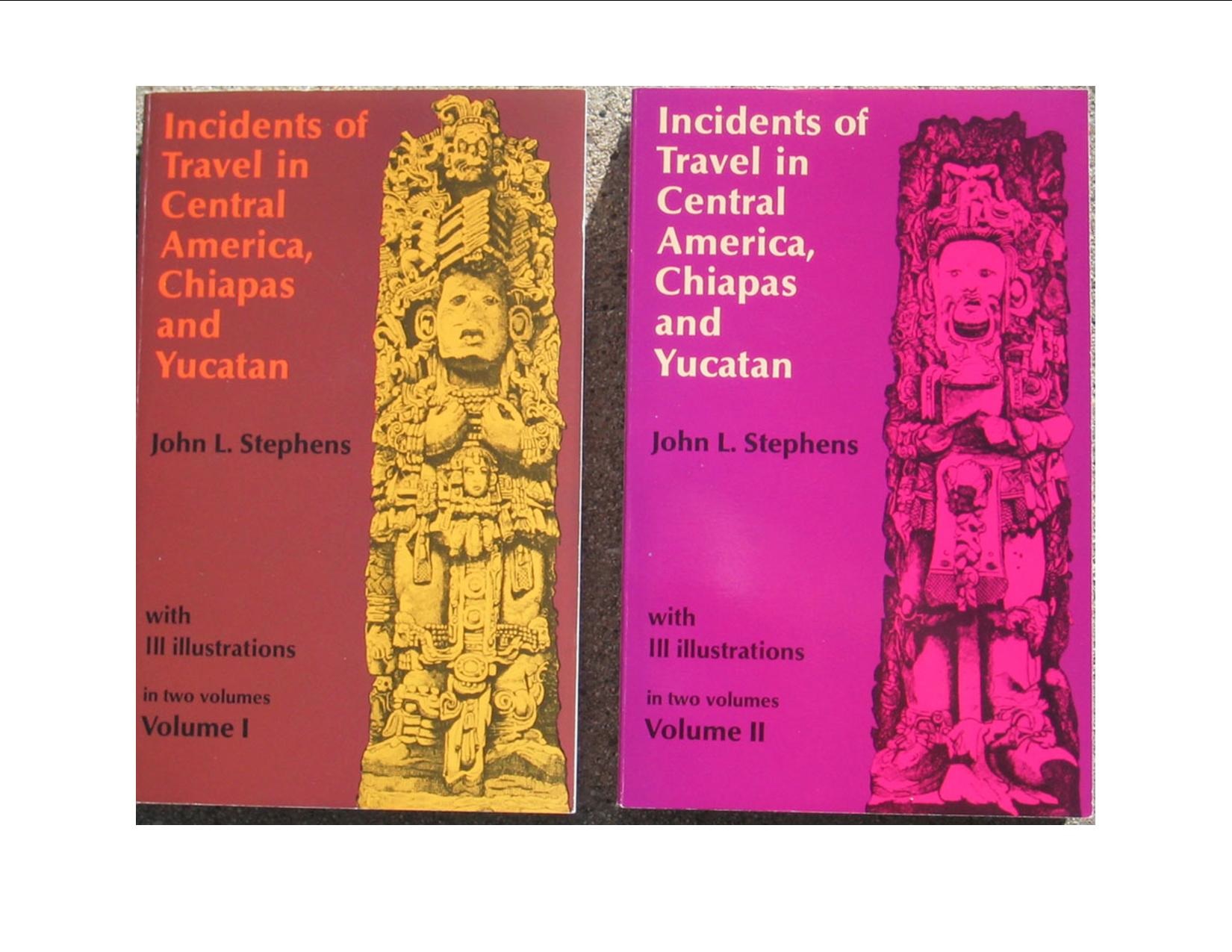
“We are not agoing (sic) to declare positively that the ruins of Quiriguá are those of Zarahemla, but when the land and the stones, and the books tell the story so plain, . . . .”
“It will not be a bad plan to compare Mr. Stephens’ ruined cities with those in the Book of Mormon.”
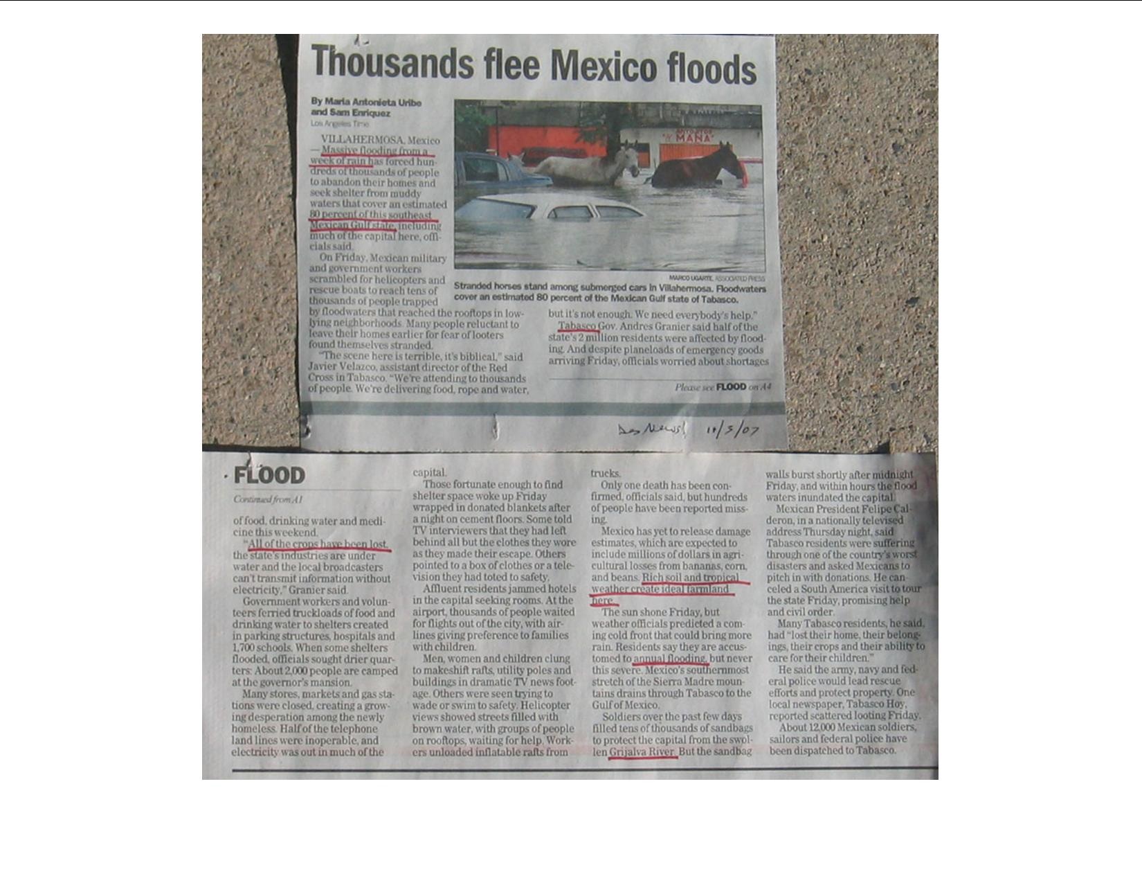
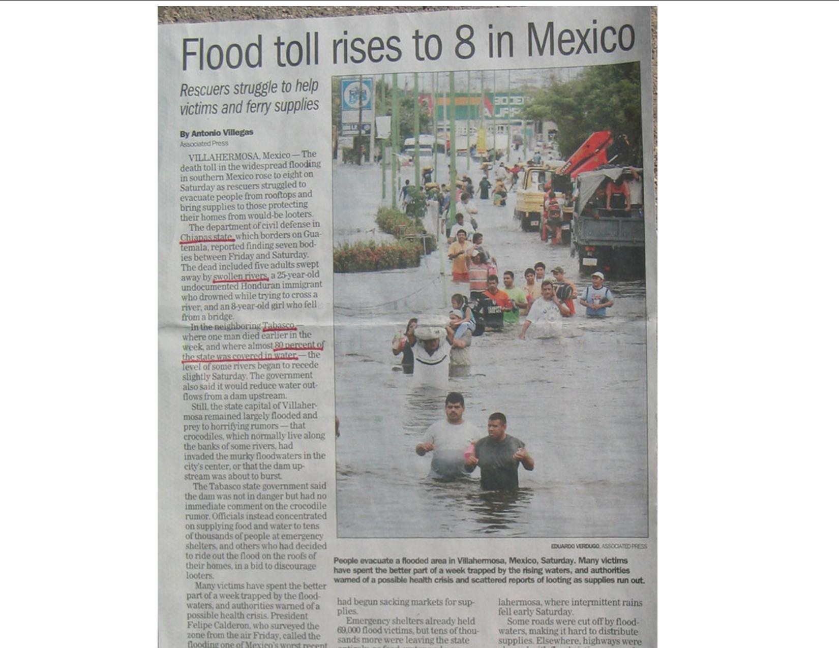
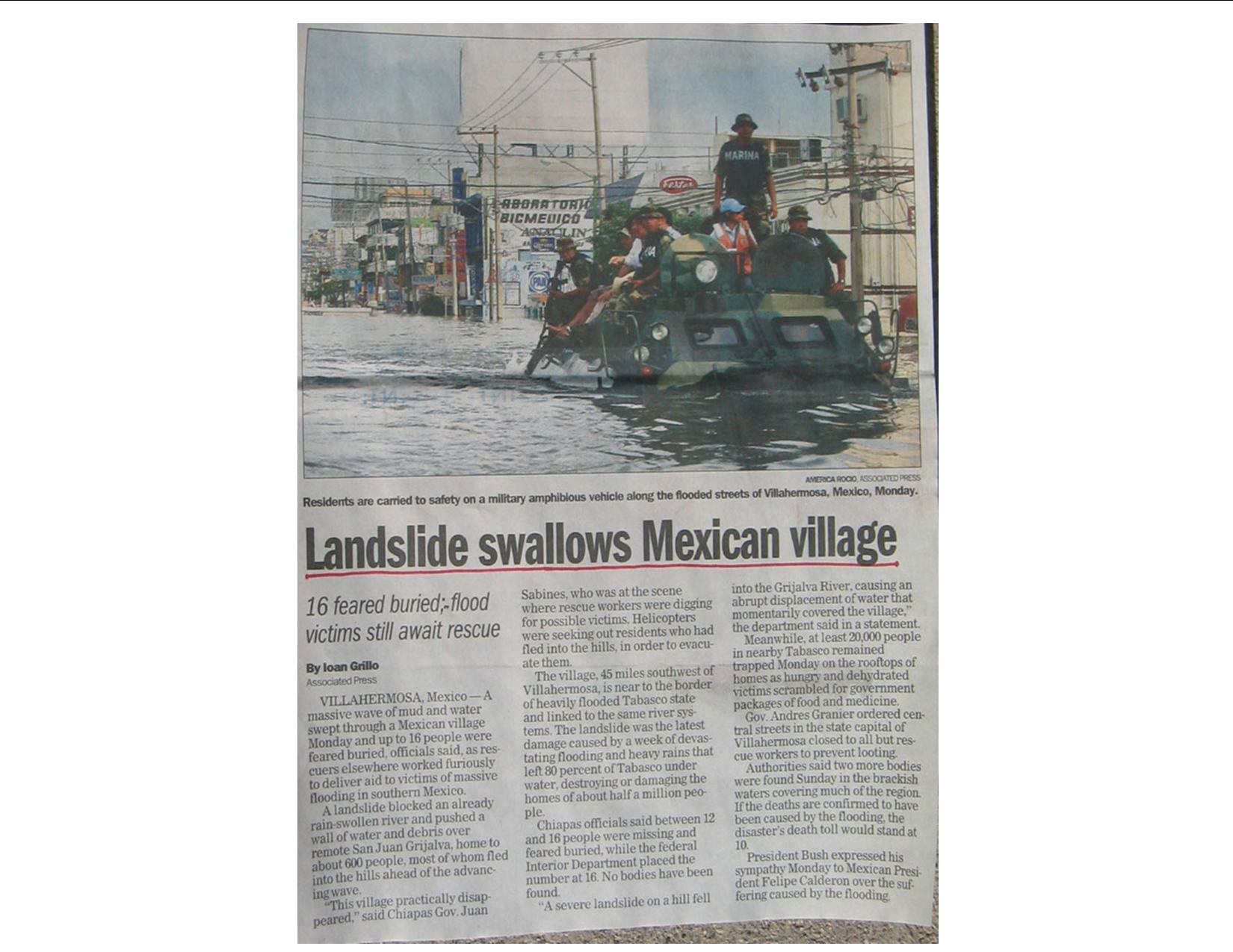
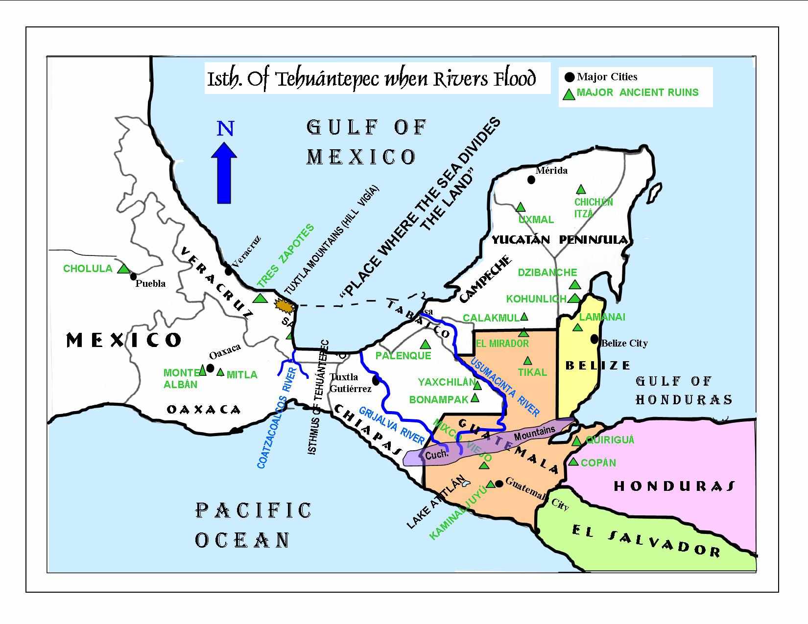
The following three newspaper clippings show and describe the extent of the flooding that can occur in the state of Tabasco, Mexico, along the gulf coast and one of the most notable locations in Mesoamerica that correlates with Book of Mormon indications.
The map below shows what the Isthmus of Tehuantepec can look like during times of extreme flooding.
Many ancient cultures did not, and do not still, look at their directions with specific references to the cardinal points of the compass as most modern Western cultures do now.
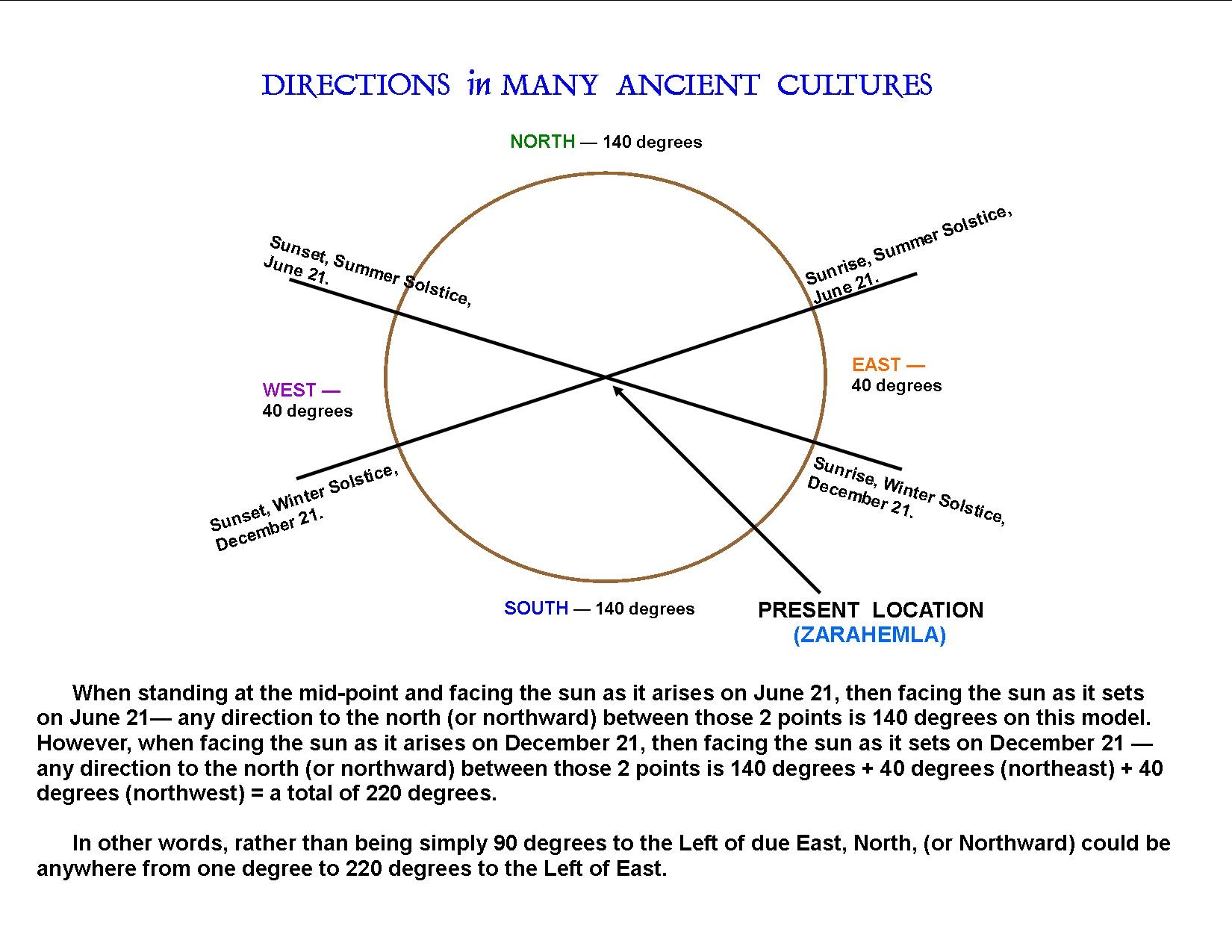
Thus, the Land Northward, as mentioned many times in the Book of Mormon, can very easily be placed in the area of southern Mexico from the Guatemala border to Mexico City even though that entire territory lies in more of a northwest to west-northwest configuration.
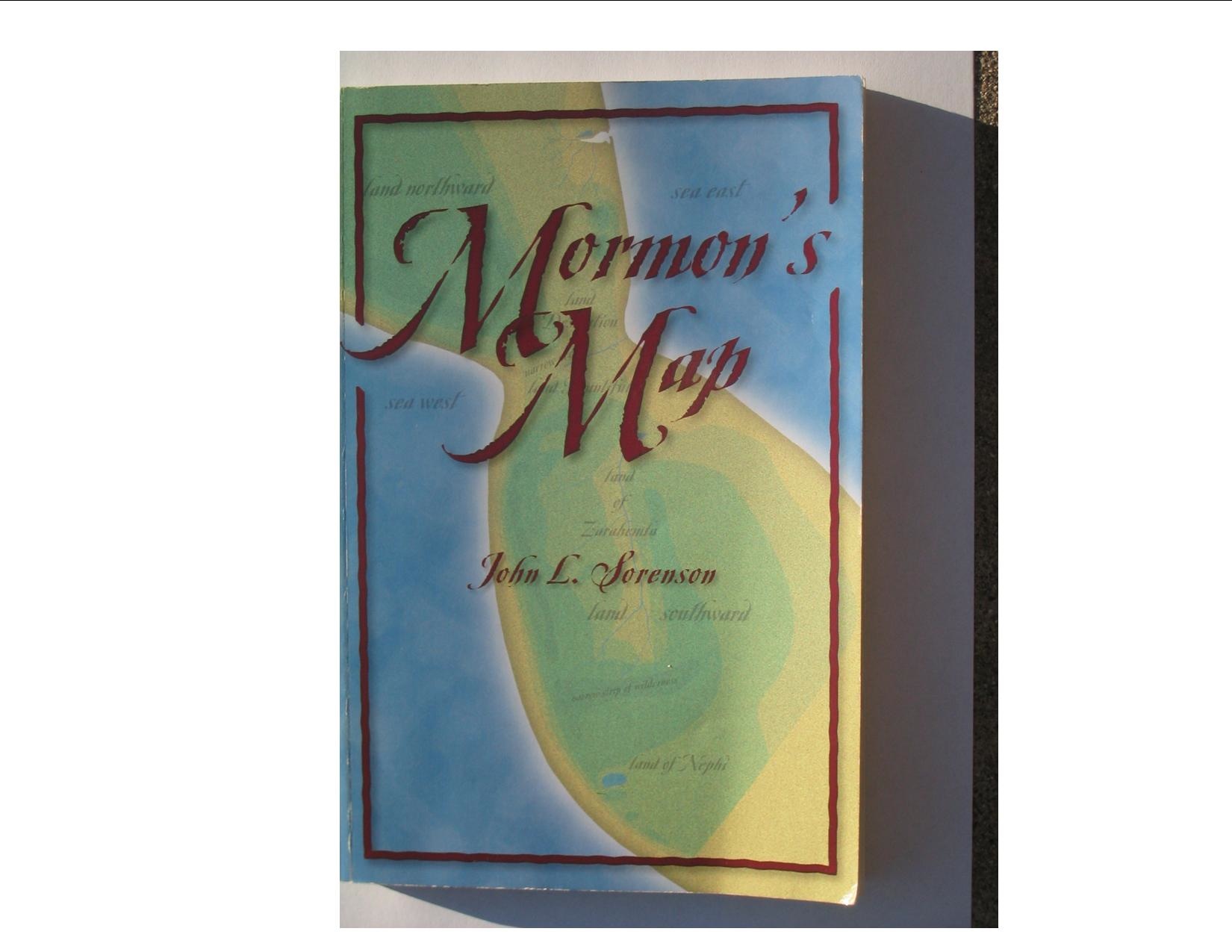
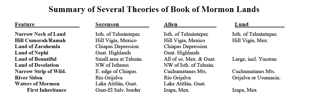
The following five models are some of the most recent, well-thought-out ideas of where many of the sites mentioned in the Book of Mormon could reasonably be located. The models are introduced by the covers of one or two books by each author, followed by the Mesoamerican map with their respective ideas presented, then followed by the same material in textual form.
(Anthropologist)

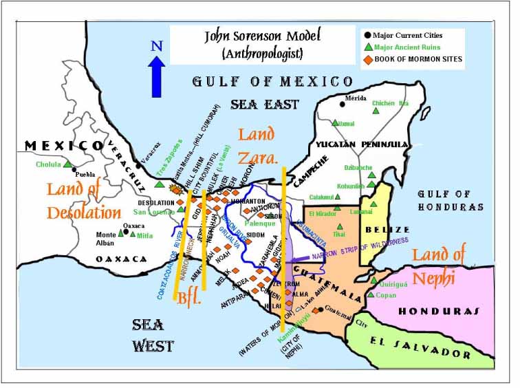
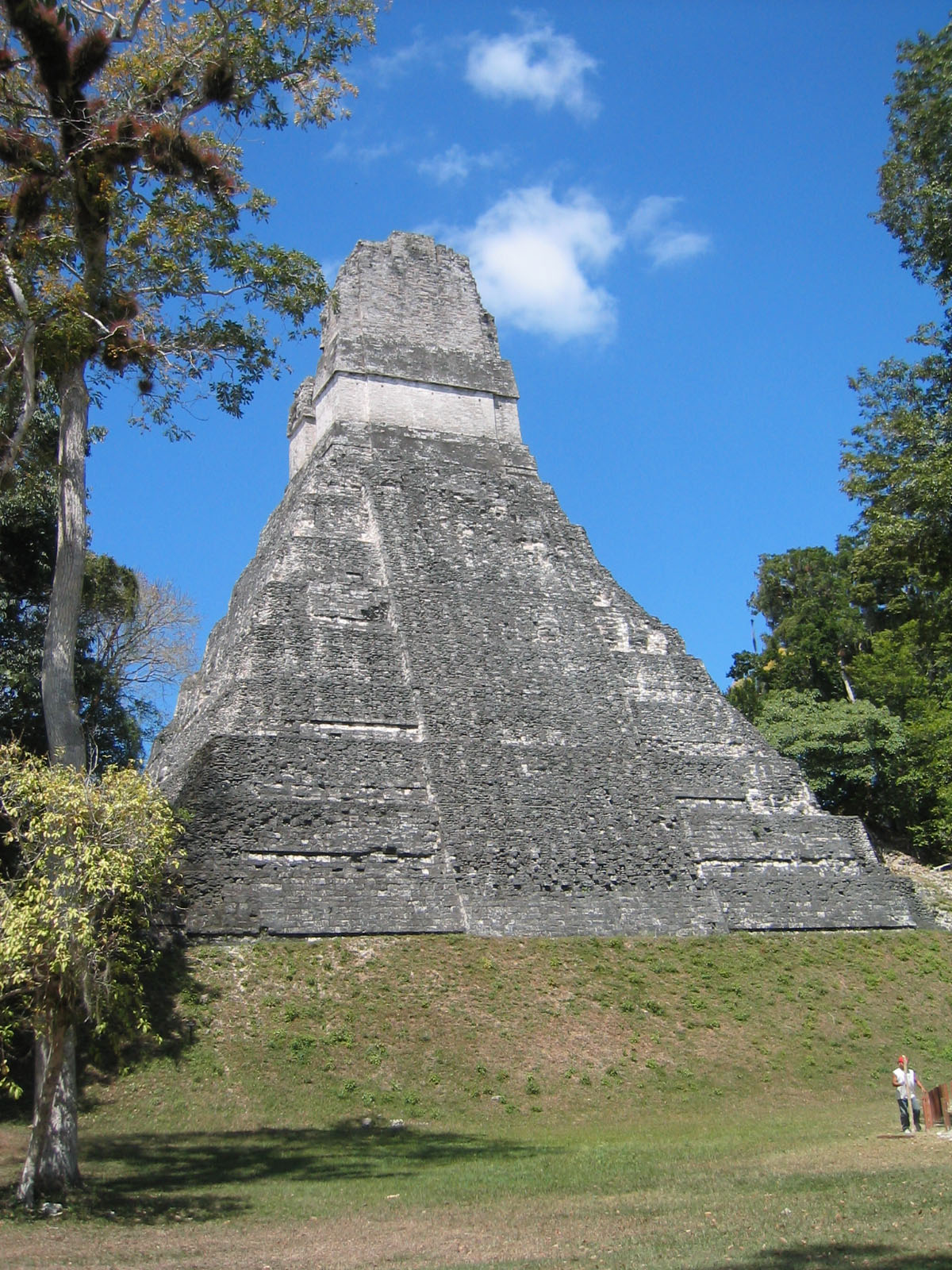
Hill Cumorah/Ramah is the Hill Vigía in the Tuxtla Mountain Range just northwest of the Isthmus of Tehuántepec
Hill Shim is in the Tuxtla Mountain range in Veracruz, Mexico
Narrow Strip of Wilderness separating the lands of Zarahemla and Nephi runs directly north and south in eastern Chiapas and western Guatemala
In order to orient his map so that the Book of Mormon lands mentioned as being northward and southward from each other, he employs a directional system that is cultural (somewhat similar to what other groups have used in the past and still do in other parts of the world) rather than as we understand the cardinal directions. On the map, this is called “Nephite North,” a designation that other scholars have applied to his concept, although he doesn’t use it himself. Under this approach, the Gulf of Mexico is the Sea East; the Pacific Ocean is the Sea West.
The chain of coastal cities mentioned with Moroni being the southernmost and Bountiful being the northernmost are along the gulf coast of Veracruz and Tabasco from roughly the mouths of the Grijalva and Usumacinta rivers to the Isthmus of Tehuántepec, a distance of approximately 75 miles. By this method, he ignores the vast Yucatán Peninsula as being in Lamanite territory and thus beyond the knowledge of the Nephite record keepers.
The Land of Bountiful is quite small and lies between the Land of Desolation at the Narrow Neck and the larger Land of Zarahemla to the south.
River Sidon is the Río Grijalva.
Land of Nephi is the Guatemalan Highlands.
Waters of Mormon likely Lake Atitlán.
Land of First Inheritance – Guatemala – El Salvador border
Current archaeological ruins or sites proposed as Book of Mormon locations.
Amatenango, Mexico – Cumeni Macuspana, Mexico – Land of Siron Amatitlán, Guatemala – Shemlon Mirador, Mexico – Ammonihah
Antigua, Guatemala – Middoni Motozintla, Mexico – Antiparah Canchon, Guatemala – Lemuel Oaxaca, Mexico – Moron
Chiapa de Corzo, Mexico – Sidom Ocozocuautla, Mexico – Noah Chicomuselo, Mexico – Judea Pinula, Guatemala – Shimnilon
Chimatenango, Guatemala – Ishmael Río Blanco, Guat – Jacobugath Chontalpa, Mexico – Nephihah Sacatepequez, Guatemala – Midian
Comitan Valley, Mexico – Gideon San Isidro, Mexico – Aaron Frailesea, Mexico – Melek San Lucas Toliman, Guatemala – Ani-Anti
Guajilar, Mexico – Zeezrom San Miguel, Mexico – Land of Jershon Huehuetenango, Guat – Valley of Alma Santa Rosa, Mexico – Zarahemla
Izapa, Mexico – City by the Sea Santiago Atitlán, Guat– Jerusalem Kaminaljuyú, Guatemala – City of Nephi Pilapan, Mexico - Teancum
Kaminaljuyú Valley, Guat. – Shilom Teapa, Mexico – Land of Antionum Laguna Mecoacan, Mexico – Moroni Tonalá, Mexico – Land of Joshua
La Libertad, Mexico – Manti Acayucan, Mexico - Jashon La Venta, Mexico – City of Mulek Huayapan, Mexico – Land of Shem
Features of the Joseph Allen Model
(Researcher, CES Instructor)

Narrow Neck of Land is the Isthmus of Tehuántepec, Mexico
Hill Cumorah/Ramah is the Hill Vigía in the Tuxtla Mountain Range just northwest of the Isthmus of Tehuántepec.
Narrow Strip of Wilderness separating the lands of Zarahemla and Nephi is the Cuchumatanes Mountain Range running from sea to sea (Gulf of Honduras to the Pacific Ocean) through southern Guatemala.
Accepts the cardinal directions as presently understood, so that the Sea East is the Gulf of Honduras, and the Sea West is the Pacific Ocean. The Gulf of Mexico, rather than being called the Sea North is “ . . . the place where the sea divides the land.” (Ether 10:20)
The chain of coastal cities mentioned with Moroni being the southernmost and Bountiful being the northernmost are along the east coast of Belize and into southern Yucatán, a distance of approximately 210 miles.
He uses one verse (Alma 22:31) to designate all the land northward from the Isthmus of Tehuántepec as Land Desolation; and all the land southward (including the Land of Nephi) as Land Bountiful. This infers that the Land of Zarahemla is a subsidiary of the greater Land Bountiful, rather than the other way around, according to most other researchers.
(Most verses that mention both lands of Bountiful and Zarahemla infer that Bountiful is smaller and a subsection of the land Zarahemla. 3 Nephi 3:23) In this way he has the Land Bountiful abutting the Land Desolation at the Narrow Neck, even though the City Bountiful is over 100 miles east across the Yucatán Peninsula on the coast of eastern Mexico. The Yucatán Peninsula is a major part of the Land Bountiful.
River Sidon is the Río Grijalva.
Land of Nephi is the Guatemalan Highlands.
Waters of Mormon likely Lake Atitlán.
Waters of Ripliancum is the Papaloapan Water Basin of Veracruz state.
Land of First Inheritance – Izapa, Mexico
Current archaeological ruins or sites proposed as Book of Mormon cities.
Cerros, Belize – Mulek Chiapa de Corzo, Mexico – Sidom Kaminaljuyú, Guatemala – City of Nephi Laman Ayin, Belize – Jershon
La Venta, Mexico – Jaredite City of Lib San Lorenzo, Mexico – Kish/Desolation (Jaredite city) Teotihuacán, Mexico – Jacobugath
Features of the Richard Hauck Model
(Archaeologist)
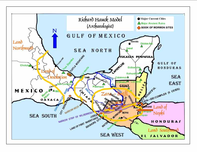
Narrow Neck of Land is a narrow transportation corridor, about 26 miles long, between the Pacific Ocean and the Sierra Madrein Chiapas, Mexico, leading to and across the Isthmus of Tehuántepec.
Hill Cumorah/Ramah is in the Tuxtla Mountain Range, a bit northeast of the Hill Vigía, just northwest of the Isthmus of Tehuántepec.
Narrow Strip of Wilderness separating the lands of Zarahemla and Nephi is the Sierra de las Minas on the east merging with the Cuchumatanes Mountain Range on the west and linking with the Sierra Madre on the west, running from sea to sea through southern Guatemala.
Accepts the cardinal directions as presently understood, so that the Sea East is the Gulf of Honduras, and the Sea West is the Pacific Ocean, as reckoned by the Nephites living in the Land of Zarahemla. The Sea South is a section of the Pacific Ocean near the Sea West; the Sea North is the Gulf of Mexico, as reckoned by the Nephites living in the Land Northward.
The chain of coastal cities: these sites are situated around Lake Izabal and northward almost to the Belize border, a total distance of less than 60 miles. Lake Izabal is connected to the Gulf of Honduras by a very wide river, so that the lake and river are considered as an extension of the sea.
The local Land of Zarahemla is in the Petén lowlands of central Guatemala in the area of Nine Hills, along the Río Usumacinta (River Sidon).
The Land of Bountiful, the Land Zarahemla, and the Land Southward are all synonymous as regarding the general larger lands. Smaller local lands are usually associated with their respective cities
River Sidon is the Río Usumacinta, with its tributaries – Río Chixoy and Río Negro.
Land of Nephi is the Guatemalan Highlands, including the Motagua River Valley and not extending much into Honduras and El Salvador.
Waters of Mormon likely in the Salamá Valley drainage to the north of the City of Nephi.
Waters of Ripliancum is the Papaloapan Water Basin in Veracruz state.
Land of First Inheritance is near Tapachula, and Izapa, Mexico.
Current archaeological ruins or sites proposed as Book of Mormon cities.
Aguacatan/Xolchun, Guatemala – Zeezrom Cambote, Guatemala – Cumeni Castile San Felipe, Guatemala – Jershon
Chamá, Guatemala – Melek Cobán, San Juan Carchas, El Paraiso, Guatemala – Manti region
El Portún/Log Mangales, Guatemala, locality – Shemlon Izapa, Mexico – Judea Possibly La Laguna/Tzalcam
(Salamá Valley), Guatemala – City of Nephi Nine Hills, Guatemala – Zarahemla San Juan/Salamá, Guatemala, locality – Shilom
Tatocapan/Pollinapan, Mexico – Cumorah/Ramah battlefield Tzutzuculi, Mexico – City Desolation
Features of the Garth Norman Model
(Archaeologist)

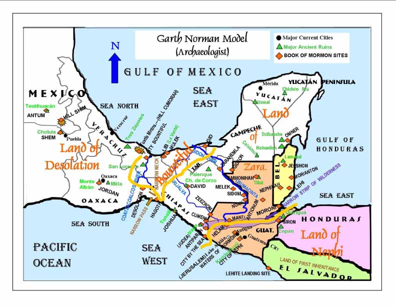
Narrow Neck of Land is the Isthmus of Tehuántepec, Mexico.
Narrow Pass is the Tehuántepec Pacific Coastal Plain
Hill Cumorah/Ramah is the San Martín volcano in the Tuxtla Mountain Range just northwest of the Isthmus of Tehuántepec.
Narrow Strip of Wilderness separating the lands of Zarahemla and Nephi are the Cuchumatanes and Las Minas Ranges.
Accepts the cardinal directions as presently understood, so that the Sea East is the Gulf of Honduras as well as the
eastern part of the Gulf of Mexico, and the Sea West is the Pacific Ocean. The Sea South, south of the Land Northward,
is the greater the Pacific Ocean near the Sea West; the Sea North is the Gulf of Mexico
The coastal cities of Zarahemla (Alma 51:26) mentioned with Moroni being the southernmost and Bountiful being the
northernmost is broken between southern and northern defense fronts. The abridged history of battles does not
include Omner in the middle, which gives place for the Yucatán Peninsula crossing. Moroni is located on the
Belize/Guatemala border, then the cities are located northward along the coast to Omner at the Belize/Yucatan
border, then due west to Golfo Aguacatal, then along the gulf coast of Mexico at city Bountiful on the Narrow Neck,
a distance of approximately 600 miles.
The Land of Zarahemla is the state of Chiapas and northern Guatemala
The Land of Bountiful is a small area of Veracruz and Tabasco, touching the Sea West on the Chiapas/Oaxaca border.
River Sidon is the Río Usumacinta.
Land of Nephi is the Guatemalan Highlands.
Waters of Mormon is likely a spring-fed lake near Antigua, Guatemala (Chimaltenango Valley).
Waters of Ripliancum is the Papaloapan Water Basin of Veracruz state.
Land of First Inheritance is Usulutan, El Salvador, just south of the Guatemalan border.
Current archaeological ruins or sites proposed as Book of Mormon cities.
Minatitlán, Veracruz, Mexico – City Bountiful False Cay, Big Creek, Belize – Lehi Juchitan, Oaxaca, Mexico – City Desolation
Cobán, Alta Verapaz, Guatemala – Manti La Venta, Mexico – City of Lib Altar de Sacrificios, Mexico – Melek
Poptún or Caracol, Belize – Aaron Río Azul, Belize – Morianton Tikal, Guatemala – Ammonihah Antigua – Mormon
Machaquia, Guatemala – Antionum Sunk off coast of Punta Gorda, Belize – Moroni El Sitio, Mexico – Antiparah
La Venta or Comalcalco, Mexico – Mulek Teotihuacán – Antum Kaminaljuyú, Guatemala – Nephi
El Jobo, Mexico – City by the Sea Tzimin Kax, Belize – Nephihah
Cambote and Salcaja, Guatemala – Cumeni Seibal, Mexico – Noah Chiapa de Corzo – David
Northern Belize, Becán, or Edzna, Campeche – Omner Aguacatal, Bellote, or Comalcalco, Mexico – Gid Cholula – Shem
La Florida, Guatemala – Gideon Dos Pilas, Mexico – Sidom Valpariso, Alta Verapaz, Guatemala – Helam
San Felipe ruins, Guatemala – Siron Xunantunich or Lamanai, Belize – Jershon Palenque region: Nueva Esperanza, Mexico – Zarahemla
Lake Atitlán – Jerusalem La Lagunita, Guatemala – Zeezrom Monte Albán – Jordan Tonalá - Joshua
Izapa, Soconusco, Mexico – Judea
Features of the John L. Lund Model
(Researcher, CES Instructor)
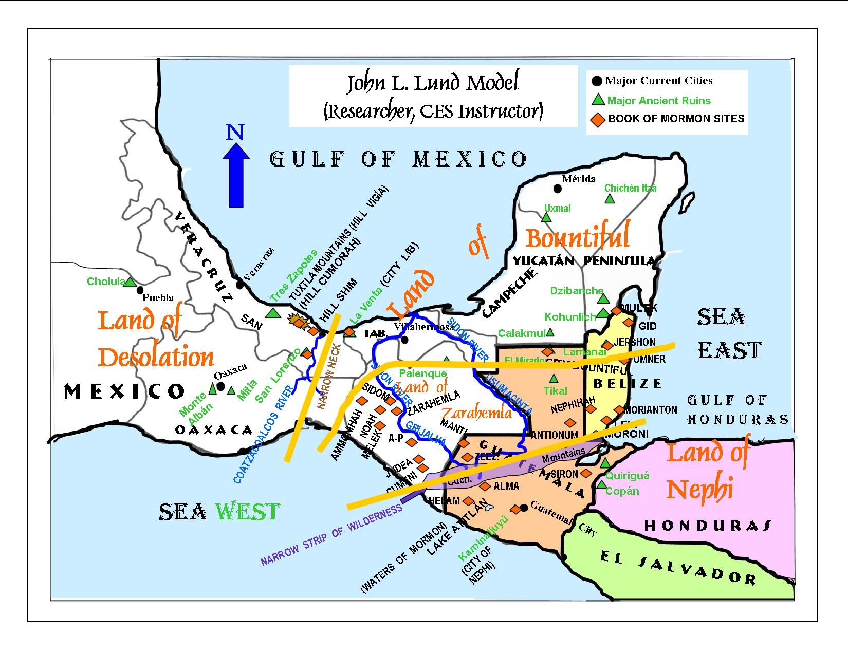
Narrow Neck of Land is the Isthmus of Tehuántepec, Mexico.
Hill Cumorah/Ramah is the Hill Vigía in the Tuxtla Mountain Range just northwest of the Isthmus of Tehuántepec.
Narrow Strip of Wilderness separating the lands of Zarahemla and Nephi is the Cuchumatanes Range.
The chain of coastal cities mentioned with Moroni being the southernmost and Bountiful being the northernmost
are along
the east coast of Guatemala and Belize, to Chetumal, in southern Yucatán, Mexico, a distance of approximately 210 miles.
The Land of Bountiful is slightly larger than the Land of Zarahemla, running from the Isthmus of Tehuántepec
through the lowlands of Veracruz, Tabasco, the northern third of Guatemala to all of the Yucatán Peninsula.
His determining of the River Sidon as being either the Grijalva or Usumacinta is undecided.
Quoting from the Prophet Joseph Smith, he has the first landing of the Lehite colony just south of the Isthmus of
Darien, on the west coast of Colombia and Panama, then journeying through the Isthmus of Darien (Panama) up
to the border of Guatemala and Mexico, near Tapachula, Mexico, and near to Izapa, which he considers to be the
Land of First Inheritance.
Current archaeological ruins or sites proposed as Book of Mormon cities.
Chiutinamit, Guatemala – City of Onihah El Mirador, Mexico – City of Bountiful Kaminaljuyú, Guatemala – City of Nephi
.jpg)