


Three Separate Lands Bountiful: Where Located? What Size? To Which Bountiful Did Christ First Appear?
Contents of all BMAF publications are the sole responsibility of the individual authors and do not necessarily represent the view of BMAF or The Church of Jesus Christ of Latter-day Saints
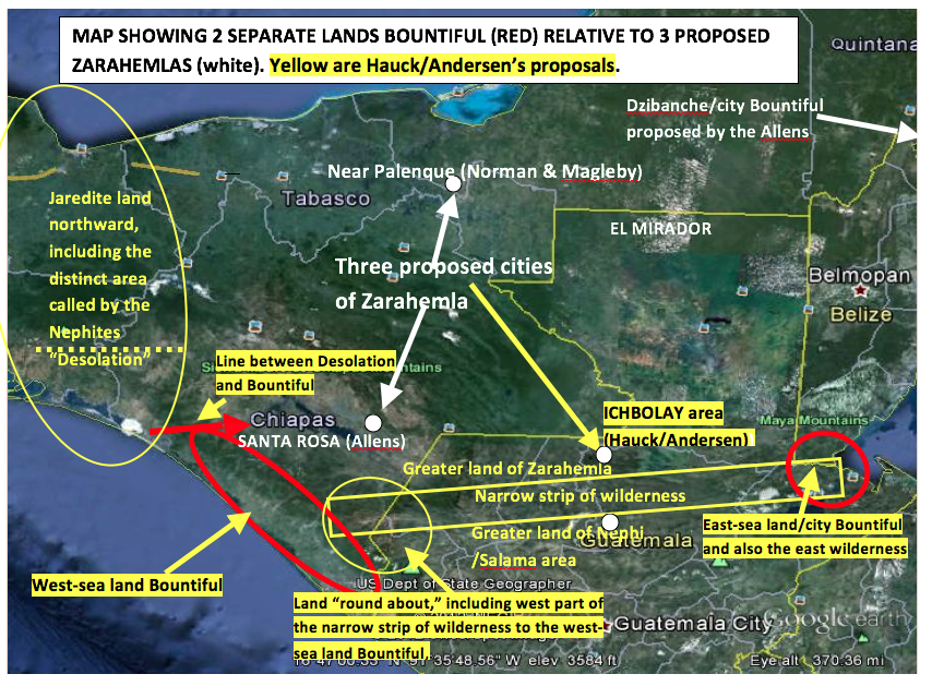
The assumption that there was only one land Bountiful in Book of Mormon geography has directly led to many diverse, confusing, illogical, strange, and unreasonable proposals for the location of Book of Mormon lands. For example, (1) Jonathan Neville[1] (Heartland Model) incredibly makes Lake Michigan the west sea; (2) John Sorenson[2] and Garth Norman[3] stretch the east sea 65 degrees from the east to the north, making the Gulf of Mexico the east sea; and (3) Kirk Magleby stretches the land Bountiful 670 miles from the east sea at Belize to the Gulf of Mexico, bypassing to the north the millions of lowland Maya then living in the El Mirador cradle of Maya existence, maintaining a slim area he still calls Bountiful along the Gulf coast to Coatzacoalcos, continuing south through the Isthmus of Tehuantepec to the Pacific Ocean, and then continuing southward along the Pacific to about Tonala so he can show one continuing land Bountiful on the east and west seas. What contrivances, contortions, and unnecessary manipulations when it is simply a matter of recognizing that Mormon clearly describes two separate lands Bountiful in the Americas.
This article will discuss the three separate lands Bountiful described in the Book of Mormon, including their similarities, their respective locations, and their relatively small sizes. It will also show that Christ initially came to the west-sea land Bountiful and not to the east-sea military outpost called city/land Bountiful. Book of Mormon quotations will be italicized, and all emphasis by bolding will be the author’s.
1. The Three Separate Lands Bountiful Described in the Book of Mormon
Briefly, the three separate lands Bountiful that are described in the Book of Mormon and that will be discussed in this article are the following:
A. The “Arabian Bountiful” where Nephi built his ship.
B. The “west-sea land Bountiful” on the Pacific coast between Izapa and about Tonala near where the “line” between Desolation and Bountiful was located.
C. The “east-sea land Bountiful,” located near the Gulf of Honduras where the city of Bountiful was located.
A. The Arabian Land Bountiful Where Nephi Built His Ship (about 590 BC)
The scriptures describing the land Bountiful on the Arabian coast are as follows:
And we did come to the land which we called Bountiful, because of its much fruit and also wild honey. . . . And we beheld the sea, which we called Irreantum, which, being interpreted, is many waters. . ..We did pitch our tents by the seashore; . . . and we called the place Bountiful, because of its much fruit. . . . I, Nephi, had been in the land of Bountiful for the space of many days. . . . I arose and went up into the mountain, and cried unto the Lord. . . . The Lord told me whither I should go to find ore, that I might make tools. . . . And we did work timbers of curious workmanship. . . . I, Nephi, did go into the mount oft. (1 Nephi 17:5–10; 18:1–3)
Obviously, this land Bountiful was not a large area, and it was bounded by a large sea (ocean) and a mountain nearby. In between was a productive land of fruit and honey and a land that had substantial rainfall. Large trees grew in the area, and iron ore could be found in the mountain. Could this description of the Arabian land Bountiful be a type and pattern for naming other limited lands Bountiful in the Americas? The answer is yes.
The Book of Mormon points out that in the promised land near where Lehi landed, there was a land Bountiful bordering on the west sea. The Book of Mormon also describes a different land Bountiful bordering on the east sea.
B. The West-Sea Land Bountiful (about 80 BC)
About 80 BC, Mormon first introduced a specific land Bountiful in the Americas, and it bordered on the west sea. In Alma 22, he gives an explanation of the lay of the land of the Nephites and Lamanites between the east and west seas and north and south of the narrow strip of mountainous wilderness. This was about the time when the sons of Mosiah were beginning to have success among the Lamanites in the land of Nephi, which was located just south of, and within eyesight of, the narrow strip of wilderness. The Nephites were inhabiting the land just north of the narrow strip of wilderness; however, the Lamanites were beginning to surround the Nephites on the east and west of the city/land of Zarahemla. The Nephites had been chasing the Lamanites out of the then-identified land of Zarahemla to the east wilderness located near the east sea. Then, in 72 BC, Moroni began chasing all the Lamanites out of all areas north of the narrow strip of wilderness.
According to Mormon, the occupation, geographic, and military situation about 80 BC was as follows:
The Nephites had taken possession of all the northern parts of the land bordering on the [narrow strip of mountainous] wilderness at [from] the head of the river Sidon, from the east to the west, round about on the wilderness side [western part of the narrow strip of wilderness]; on the north [from the western part of the narrow strip of wilderness], even until they came to the land which they called Bountiful. (Alma 22:29)
And it [the Bountiful that bordered the west sea] bordered upon the land which they called Desolation, it [the Desolation that also bordered on the west sea] being so far northward [from the narrow strip of wilderness] that it [Desolation] came into the land which had been peopled and been destroyed. (Alma 22:30)
The Nephites had inhabited the land Bountiful, even from the east unto the west sea. (Alma 22:33)
It was only the distance of a day and a half’s journey for a Nephite, on the line [between] Bountiful and the land Desolation, from the east to the west sea [the line was only about fifteen miles in length]. (Alma 22:32)
The land on the northward [of the line] was called Desolation, and the land on the southward [of the line] was called Bountiful, it [Bountiful located on the west sea] being the wilderness which is filled with all manner of wild animals of every kind, a part of which had come from the [Jaredite] land northward for food. (Alma 22:31)
Because Desolation “came into” the Jaredite land northward (see Alma 22:30 above), then Desolation was not synonymous with the land northward but was a subdivision thereof. Because the Nephites had taken possession of the land northward of the narrow strip of wilderness until they “came to the land which they called Bountiful” (see Alma 22:29 above), then this land Bountiful could not have been synonymous with the land southward but must have been a small subdivision thereof. Also it could not have included the city/land of Zarahemla.
It is irrefutable that there was a land Bountiful that bordered the west sea. This is made even more emphatic in the year 56 BC when Hagoth launched his ships into the west sea from the land Bountiful near the same “line.”
Hagoth . . . built him an exceedingly large ship, on [within] the borders of the land Bountiful by [near but not in] the land Desolation, and launched it forth into the west sea, by [near but not in] the narrow neck which led into the [Jaredite] land northward. (Alma 63:5)
There was a land Bountiful that was located on the west sea (the Pacific) and it bordered the land known by the Nephites as Desolation, which was also located on the west sea. There is only one west sea mentioned in the Book of Mormon. There is nothing in the Book of Mormon that justifies locating a second west sea anywhere let alone on the west side of the Yucatan Peninsula.[4] Hereafter, this Bountiful will be called the west-sea land Bountiful, referring to the Pacific Ocean as the west sea. This Bountiful was first identified by name about eight years before Moroni established the city Bountiful on the east-sea coast—ca. 72 BC. The description of the west-sea Bountiful is similar to the description given of the promised land where Lehi landed and lived for two or three years until he died and then the Nephites migrated inland.[5] It is also similar to the description given for the Arabian land Bountiful.
C. The East-Sea Land Bountiful (about 77 BC)
The Book of Mormon first identifies the east-sea land Bountiful about 77 BC. This was the time when the Ammonites were camped near Manti up in the narrow strip of mountainous wilderness awaiting the decision of the Nephites as to where to locate the Ammonites.
Behold, we will give up the land of Jershon, which is on the east [of Zarahemla] by the sea, which [Jershon] joins the land Bountiful, which [Jershon] is on the south of the land Bountiful; and this land Jershon is the land which we will give unto our brethren for an inheritance. . . . And they went down [from near Manti in the narrow strip of mountainous wilderness] into the land of Jershon [located near the east sea]. (Alma 27:22, 26)
Notice that the land of Jershon is identified as a land different than, and south of, the east-sea land Bountiful, begging the following questions: (1) How large an area was the land Jershon? (2) and How large an area was the separate east-sea land Bountiful? Notice also that the land of Jershon was located on the east-sea coast and that the east-sea land Bountiful was located north of Jershon and not west. Therefore, this land Bountiful must have also been located near the east-sea coast. In fact, this east-sea Bountiful was located within eyesight of the east seashore (see Alma 51:32 and 52:1). This land Bountiful is never described as being large; never as being the same as “the land southward”; and never as being the same as the land of Zarahemla (Helaman 1:28–30). Therefore, it must have been deemed by Mormon as a separate land.
Like Jershon and Mulek, this east-sea land Bountiful was also described as being located very close to the shore of the east sea. About the end of the year 67 BC, the Lamanites had captured all the east-sea coastal cities northward from the narrow strip of wilderness (aka “line of possessions of the Lamanites)” except the city Bountiful. Amalickiah was pushing northward along the east-sea coast attempting to conquer the east-sea city/land Bountiful and then desiring to push on to the east-sea land northward that was located northward from the east-sea city/land Bountiful. Teancum was trying to stop him. (Notice in the following scripture how the term “borders of” takes on the meaning of “very close to.”) Notice also that the distance between Bountiful and Mulek could not have been more than half a day’s march (five miles or so).[6]
They marched [northward from Mulek] to the borders of the land Bountiful, driving the Nephites before them and slaying many. . . . [Teancum] headed Amalickiah also, as he was marching forth with his numerous army that he might take possession of the land Bountiful, and also the land northward [of the land Bountiful because he was going in the wrong direction, north, to go to the Jaredite land northward]. . . . [Teancum gained advantage over Amalickiah and] they [the Nephites] did slay them [the Lamanites] even until it was dark. . . . Teancum and his men did pitch their tents in the borders of the [city/land Bountiful; see Alma 52:17] land Bountiful; and Amalickiah did pitch his tents in the borders [of the land Bountiful] on the beach by the [east] seashore. . . . Teancum stole privily into the tent of the king and put a javelin to his heart. . . . He returned again privily to his own camp. . . . He caused that his armies should stand in readiness, lest the Lamanites had awakened and should come upon them. (Alma 51:28–36)
On the first morning of the first month, behold, they found Amalickiah was dead in his own tent; and they also saw that Teancum was ready to give them battle. . . . They abandoned their design in marching into the land northward [from the east-sea Bountiful], and retreated [southward along the seashore] with all their army into the city of Mulek [located on the east-sea shore less than a half day’s march from land Bountiful]. (Alma 52:1)
The place where Teancum was camped in the east-sea land Bountiful refers to the city of Bountiful because in Alma 52:17, Mormon says that Teancum “returned again to the city Bountiful.” This is the first reference in the Book of Mormon to the city Bountiful. Why would Teancum have been stationed at any other location than the new military outpost at city Bountiful?
Clearly, this east-sea land Bountiful (which later became the “land or the city, Bountiful”; Alma 52:17; 53:3), was located very close to the east sea. The distance between the camp of Moroni near Bountiful and the camp of Amalickiah on the beach near Bountiful could not have been more than a mile or so away (because they could see each other), proving that the east-sea land Bountiful was located right by the east-sea coast, east of Zarahemla, and not inland some forty miles[7] (see also endnote 2).
From the above scriptures, it appears that about the end of 72 BC, the east-sea city/land Bountiful was located:
Because the east-sea land Bountiful was located to the east of Zarahemla, east of the Pacific Ocean and eastward and northward from the east end of the narrow strip of wilderness, then the east-sea land Bountiful must have been located near the Gulf of Honduras, and within not more than about thirty miles or so of where the city of Moroni was located, which will be shown hereafter.
Therefore, the Book of Mormon conclusively identifies an east-sea land/city Bountiful (on the Gulf of Honduras) and a west-sea land Bountiful (on the Pacific) at least 250 air miles apart.
2. Were the Lands Bountiful Connected or Were They Separate?
One of two theories must be true: Either there was one large land Bountiful that extended from the east sea 250 air miles to the west sea or there were two separate, and relatively small, lands Bountiful within the greater land southward (which encompassed everything south of the “line” between the west-sea land Bountiful and the west-sea land Desolation). The only scripture giving any possible implication that the two lands Bountiful might have been connected is in Alma 22:33, which states:
The Nephites had inhabited [not just controlled or possessed, but inhabited] the land Bountiful, even from the east unto the west sea.
It is important to determine the time frame of when this land bountiful was exclusively inhabited by the Nephites from the “east unto the west sea.” This can be determined by finding out the only time when the Lamanites were ever “hemmed in” on the south of the narrow strip of wilderness because that is the time period that Mormon is referencing in Alma 22:33–35. Prior to 72 BC, the Lamanites were not hemmed in but had nearly surrounded the Nephites. That is why Moroni had to establish the defensive line at the narrow strip of mountainous wilderness from the east sea to the west sea and to force “all” the Lamanites to live south of that line of possession.
The only time the greater land of Zarahemla was inhabited exclusively by the Nephites—the Lamanites having been “hemmed in” to the south of the narrow strip of wilderness from the “east unto the west sea”—had to have been between 72 and 67 BC (Alma 51 when Amalickiah conquered all east-sea cities except Bountiful). This was a period of only five years.
Some scholars claim that this scripture implies an east sea; however, this scripture does not say the “east sea.” The Allens and Hauck agree that the wording “from the east unto the west sea” does not mean from the east sea to the west sea. The same construction of the same wording in Alma 22:32 should prevail in this scripture. The Allens agree with this meaning of Alma 22:33 and Alma 22:32,[8] with the exception that they propose that the size of the land Bountiful was the same as the size of the whole of “the land southward”—including the land of Nephi as shown on the Allens’ map on page 307[9]—as a reflection of Alma 22:31: “The land on the southward was called Bountiful.” They expand on that thinking as follows: “This type of geography is consistent with several city and state names today in Mexico. For example, Oaxaca is a city in the state of Oaxaca, Puebla is a city in the state of Puebla, Veracruz is a city in the state of Veracruz, and Mexico City is a city in the state of Mexico. All these are also located within a larger land called the country of Mexico. This would have been justifiable statement had Moroni stated “the land southward was called Bountiful.” He did not say it and therefore did not meant it. The term “on the southward is directional, not a noun, and the referent is the line between Desolation and Bountiful.
The Allens further claim that because the greater land southward extended from the east sea to the west sea, then this single land Bountiful (their country Bountiful) must have included both seas. Both of these conclusions are inaccurate and not supported by the Book of Mormon.
Consider Alma 22:29–31, which, in fact, shows that the land Bountiful is not the same as the land southward; therefore, there must have been two separate lands Bountiful and not one country called Bountiful:
About 72 BC: And thus the Nephites were nearly surrounded by the Lamanites; nevertheless the Nephites had taken possession of all the northern parts of the land bordering on the wilderness, at the head of the river Sidon, from the east to the west, round about on the wilderness side; on the north, even until they came to the land which they called Bountiful. (Alma 22:29)
This is clearly not talking about the city/land Bountiful located on the east sea. If the land Bountiful were the same as the land southward, then how could they come to the land Bountiful if they were already in the land Bountiful? The very least this scripture holds is that the land Bountiful could not have included the land of Nephi, which was south of the narrow strip of wilderness. Therefore, “land Bountiful” was not synonymous with “land southward.”
The referent here for the term “on the north” in Alma 22:29 is the narrow strip of wilderness. Initially (prior to 72 BC), the Nephites did not control the areas east or west of the city/land of Zarahemla because the Lamanites nearly surrounded them. However, the Nephites had taken possession of all the land north of the narrow strip of wilderness from about the head of Sidon westward to the west sea. In Alma 52:11 (66 BC), Moroni states, “I would come unto you but behold, the Lamanites are upon us in the borders of the land by the west sea.” How far north from there we are not told except that from the western part of the narrow strip of wilderness (where Moroni was stationed at the time near the “west sea south”), possession by the Nephites did extend to the line between Bountiful and Desolation, which line also began on the west sea and extended “only the distance of a day and a half’s journey” (Alma 22:32).
Moroni was in a very precarious and “dangerous circumstance” in trying to control the mountainous line of defense that he had recently created from the east sea to the west sea. He was trying to protect all of the Nephites possessing the land north of the narrow strip of wilderness. This protection was especially important in the area northward from the western part of the narrow strip of wilderness, which Moroni was defending at that time. By 67 BC, the Lamanites had already “re-conquered” all the east-sea areas, including all the new Nephite cities to and including Mulek. The area where Moroni was stationed within the western part (“round about”) of the narrow strip of wilderness also bordered (but was a distinct land from) the west-sea area called Bountiful.
It appears that the wording “to the west, round about on the wilderness side” means that the Nephites were in possession not only of the land north of the narrow strip of wilderness but also within the mountainous area in the western part of the narrow strip of wilderness. They inhabited that area and also the whole of the west-sea land Bountiful, which land bordered along the Pacific until it came to the “line” between Bountiful and the land Desolation. This west-sea land Bountiful was in width about 12 to 20 miles “from the east to the west sea” (see Alma 22:33 below). If the length of the line (which extended a day and a half from the east to the west sea) between Bountiful and Desolation was about twelve miles, according to Exploring the Lands of the Book of Mormon[10] and if that line went from the “east to the west sea,” then the same meaning must be given to the width of the land Bountiful along the Pacific coast. The Nephites inhabited and controlled all of this land from the narrow strip of wilderness northward to the “line” between Bountiful and Desolation and from the Sierra Madre Mountains to the Pacific Ocean.
Thus the land on the northward [of the line between Desolation and Bountiful] was called Desolation, and the land on the southward [of the line] was called Bountiful, it [Bountiful] being the wilderness which is filled with all manner of wild animals of every kind, a part of which had come from the land northward for food. (Alma 22:31)
Notice that the first “northward” does not say “the land northward”; rather, it says “on the northward.” Therefore, the term “on the northward” is directional, and the referent is “the line.” The second time “northward” is mentioned, Mormon writes “the land northward,” meaning the Jaredite land northward. Mormon clearly knew the difference and is telling us that the Nephite-designated “Desolation” was but a small part of the greater Jaredite land northward.
Notice also that Bountiful is described as “the wilderness” where the animals came from the land northward (see Ether 10:19–20). Is the entire land southward, from the isthmus to Salvador and from the Pacific to the Yucatan, this “Jaredite-named wilderness” to where the animals fled? I believe not. This “Jaredite-named wilderness” is identified by Mormon as the Nephite land Bountiful that bordered the west sea. It was a subdivision of the land southward and was not synonymous with the greater land southward. Certainly the land Bountiful did not include all of the land of Nephi located south of the narrow strip of wilderness, whereas the land southward did include all of the land of Nephi.
It is incredible that one could reasonably claim that a single use of the directional term “on the southward” would mean that the entire area from the isthmus to Salvador and from the Pacific to the top of the Yucatan was a country called the land Bountiful. Which was it—the country called Bountiful or the country called “the land southward?” Did Mormon not know the difference? The referent for the phrase “on the southward” was the “line between Bountiful and Desolation” and that line was only about twelve to twenty miles in length. This west-sea land Bountiful was located southward of that twelve- to twenty-mile line.
And it came to pass that the Nephites [not Lamanites] had inhabited the land Bountiful, even from the east unto the west sea, and thus the Nephites in their wisdom, with their guards and their armies, had hemmed in the Lamanites on the south [of the narrow strip of wilderness], that thereby they should have no more possession on the north [of the narrow strip of wilderness], that they might not overrun the land northward. Therefore the Lamanites could have no more possessions only in the land of Nephi [and not in the land Bountiful or in the land of Zarahemla] and the wilderness round about. [The Lamanites were also inhabiting the western part of the narrow strip of wilderness (see verse 29), “round about” indicating that the western part of the narrow strip of wilderness was perhaps not as narrow as the eastern part of the wilderness. (Alma 22:33–34)
If the land Bountiful was the same as the land southward, then the land Bountiful would have to have included areas where the Lamanites inhabited because the land southward included the land of Nephi south of the narrow strip of wilderness. Was Mormon confused again as claimed by Magleby (see endnote 16)? Did Mormon not know the difference between “on the north” and “the land northward.” If he meant them to be the same, why did he use different terms?
The referent for the phrase “on the south” is again the narrow strip of wilderness. The only time and place where the Lamanites had been hemmed in by the Nephites occurred when Moroni, in the year 72 BC, established the defensive line along the narrow strip of wilderness from the east sea to the west sea. The phrase “no more possession on the north” clearly indicates that the Lamanites had possessed some of the Nephite land north of the narrow strip of wilderness until they were driven out and into the land south of the narrow strip of wilderness. The wording “no more possession on the north” could not have meant the Jaredite land northward because to this time, no Lamanites had inhabited any of the land of Desolation, let alone any of the rest of the Jaredite land northward.
The wording “that the Nephites had inhabited the land Bountiful, even from the east unto the west sea” does not mean from the east sea to the west sea. It means that the west-sea land Bountiful (which was exclusively inhabited by the Nephites at that time) was in width the distance of about twelve to twenty miles or so from some point or object just east of the west sea and from there westward to the west sea. This should have the same meaning as Alma 22:29.
At the minimum, the west-sea land Bountiful had an eastern boundary that was not the east sea. Therefore, there had to have been two separate lands Bountiful. If the land Bountiful on the Arabian Peninsula is any indication of the size and boundaries of the west-sea land Bountiful, then the eastern boundary should be a mountainous area. The eastern boundary of the west-sea land Bountiful was the Sierra Madre Mountains. This was the same boundary where the “line” between Bountiful and Desolation ended (the day and a half’s journey). It was the same line (a day in length) where Moronihah stationed his army to defend their “north country” in 35 BC (Helaman 4:6–7).
They [Lamanites] succeeded in obtaining possession of the land of Zarahemla; yea, and also all the lands, even unto the land which was near the land Bountiful. The Nephites and the armies of Moronihah were driven even into the land Bountiful. [clearly, the land Bountiful was a different land than the land of Zarahemla. How could they have been driven into the land Bountiful if they were already in the land Bountiful? Therefore, the east-sea land Bountiful and the west-sea land Bountiful were not connected.] (Helaman 4:5–6)
As shown on the map below, the size of the west-sea land Bountiful was limited to the area that extended from the narrow strip of wilderness on the south to the “line” between Bountiful and Desolation on the north and from the west sea to some barrier (the Sierra Madre Mountains) about twelve to twenty miles to the east of the west sea, a relatively small area compared to the whole of the land southward.
The conclusion seems apparent that the Book of Mormon does not describe one large land (country) Bountiful that was synonymous with the land southward; rather, there were two relatively small and separate lands Bountiful in the land southward.
Starting about 72 BC, the term “Bountiful,” referring to the east-sea land Bountiful, was used several times. It was not until about 65 BC that this east-sea land Bountiful was identified as a city. Moroni had fortified the west-sea area, and then, while he was marching from the west-sea cities to the east-sea land Bountiful, Teancum, (who was stationed at the land/city Bountiful), attempted to retake Mulek:
65 BC: But he saw that it was impossible that he could overpower them while they were in their fortifications; therefore he abandoned his designs and returned again to the city Bountiful to wait for the coming of Moroni that he might receive strength to his army. (Alma 52:17)
Teancum had been camping in the east-sea land Bountiful area (see Alma 51:32, 35 and 52:9), but now for the first time it is called “city Bountiful.” About a year after Moroni had left the west-sea area and joined Teancum at the east-sea land or city Bountiful, the Nephites recovered Mulek by stratagem and took many prisoners:
64 BC: After the Lamanites [prisoners] had finished burying their dead and also the dead of the Nephites, they were marched back into the land Bountiful; [Notice the battle at Mulek was not in the land Bountiful. They had marched out of the land Bountiful and then back into the land Bountiful]. Teancum, by the orders of Moroni, caused that they should commence laboring in digging a ditch round about the land, or the city, Bountiful. (Alma 53:3)
Because the city/land of Mulek was in a different land than the land Bountiful means that the city/land Bountiful must not have been a large area. The distance between the two cities could not have been more than a half day’s march (about five miles; see endnote 2). If half of the distance belonged to Mulek and the other half to Bountiful, then it would mean that the land supporting Bountiful was about three miles on each side of the city Bountiful. This gives more credibility to the statement that the prisoners had to dig a ditch around “the land, or the city, Bountiful.” Perhaps in digging the ditch around the “land, or the city, Bountiful” they defined the “city limits” of the new city Bountiful. They did not dig a ditch from the east sea to the west sea!
The wording “the land, or the city, Bountiful,” written by Mormon, was not a lapse of memory or confusion or error on Mormon’s part as suggested by Kirk Magleby (see endnote 16). Rather, this statement, or something similar, is repeated twenty-four times, clearly meaning the area immediately surrounding and supporting the named city. These twenty-four scriptures are quoted in endnote 16. Although it is also true that Mormon’s use of the words “land, or city” could be an emendation[11] because he could not have erased the word “land,” it seems more likely to this author that because he made the same “mistake” so many times, there must be a better meaning. Maybe the word “or” in their language meant the same thing as a “/” in English.
The foregoing corroborates that the east-sea land Bountiful and the city Bountiful were virtually the same area and not a large area. The east-sea land Bountiful bordered the east sea east of Zarahemla near the Gulf of Honduras. It was located north of Mulek about five miles. It was a land of plenty of rainfall and fruits just like the Arabian Bountiful. It did not extend across the Yucatan to the Gulf of Mexico. It was not located north of the lowland Maya heartland. It did not extend continuously (a most difficult seven-hundred-mile circuitous route; see endnote 12) from Belize to Campeche, to Tabasco, to the Isthmus of Tehuantepec, and then to Tonala, as claimed by Magleby.
There is no Book of Mormon support for such theories. I agree with Dr. Hauck’s conclusion, as stated in his book, Deciphering the Geography of the Book of Mormon, that the Book of Mormon “contains no support for the all-encompassing single land Bountiful theory.”[12]
Therefore, the relatively small size of the east-sea land Bountiful confirms that there was not just one large Bountiful but two separate, relatively small areas, each called Bountiful, and that each followed the pattern and description of the Arabian land Bountiful.
Superimposed on a Google map of the area are the following:
4. Christ First Appeared at West-Sea Land Bountiful
I propose that Christ did not initially come to the city Bountiful or the east-sea land Bountiful but to a temple located within the west-sea land Bountiful, probably Izapa, as proposed by Hauck (see endnote 14). This conclusion is based upon the following summary of evidences and rationale:
1. The Book of Mormon never mentions a temple in any east-sea location or in any area east of the river Sidon.
2. The Book of Mormon never states that Christ came to the city Bountiful.
3. City Bountiful and east-sea land Bountiful are never mentioned after 30 BC. (Helaman 5:14), although the east sea is implied in Helaman 11:20, about AD 34 when city Moroni was sunk into the depths of the sea.
4. From 30 BC forward, the term “Bountiful” always has reference to the west-sea land Bountiful.
5. City Bountiful was located at the extreme northeastern area of the Nephite occupation on the east-sea coastal area, and most of the Nephites were not living there. This was a military defensive outpost.
6. There is no evidence that any Nephite or Lamanite ever lived in, or traveled north of, the east-sea city Bountiful.
7. Lachoneus did not go to the east-sea Bountiful area for protection but to the west-sea Bountiful in the year 17 AD. He located on the line between Desolation and Bountiful.
8. West-sea Bountiful was located more near the heartland of the Nephites about the time of Christ’s appearance. They had spread from Zarahemla to the Pacific coastal area and northward, including into the Jaredite land northward (the entire Isthmus Tehuantepec).
9. The Maya had so heavily populated the areas of northern Peten and Belize from 1500 BC to the time of Christ’s resurrection that it would have been impossible for there to have been substantial numbers of faithful Nephites, including faithful Lamanites, in that area.
10. The areas of northern Peten, Yucatan, and Belize were too far from Zarahemla for the Nephites to have conquered and then effectively converted, protected, and governed. This would have been especially true if Santa Rosa—the Allens’ proposed city Zarahemla located three hundred air miles distant on the Grijalva River—was the city of Zarahemla.
11. There is no evidence that the Maya in Belize, Peten, and Yucatan ever practiced a Christian religion or lived the law of Moses.
12. The area of northern Belize—proposed by some scholars as the city of Bountiful—is not an area that would likely have suffered the extensive damages mentioned at the time of the Crucifixion, whereas the area of Izapa is located near the area of the most extensive volcanic activity in Central America.
13. The area of Izapa is located south of the narrow strip of wilderness within the original land of Nephi, and the area south of the narrow strip of wilderness suffered less damage than the area north of the narrow strip of wilderness (see 3 Nephi 8:11–12).
14. The Lord promised that the more righteous Lamanites would be more protected than the more wicked Nephites.
15. The church headquarters never left Zarahemla until about the time of Christ’s appearance but before the city was destroyed by fire (see endnote 2). All of the leaders of the church from Helaman; to his son Helaman; to Nephi, son of Helaman; to Nephi, son of Nephi (who was the leader of the church prior to the time Christ appeared to the people at Bountiful) resided in the city of Zarahemla, and they had the records there with them. They never lived in the city Bountiful.
There must have been good reasons for Lachoneus (in the year AD 17) to have relocated his “tens of thousands” of Nephites (including righteous Lamanites and their armies) after abandoning Zarahemla and other cities to the robbers (led by Giddianhi; 3 Nephi 3–4) to an area near the west-sea coast and adjacent to the “line between Desolation and Bountiful” (see verse 23). The Nephites were already familiar with the west-sea area. It would have been near where they had support from those Nephites who had relocated there. This was also close to the same area where Hagoth had built and launched his ships some sixty years or so previously. Surely there were friendly Nephites in this appointed area. This proposed area, located near Horcones, Mexico, was also very defensible. It also seems reasonable that they would have traveled along a major route (see Stoddard’s comments at endnote 15) and not a footpath in the wilderness somewhere because Mormon tells us the following:
[They took their] horses, and their chariots, and their cattle, and all their flocks, and their herds, and their grain, and all their substance and did march forth by the thousands and by tens of thousands, until they had all gone forth to the place which had been appointed. . . . And the land which was appointed was the [greater] land of Zarahemla [as opposed to the Jaredite land northward], and the land which was between the land Zarahemla and the [west-sea] land Bountiful, [therefore, the land Bountiful could not have included the land of Zarahemla; both of these separate lands were located in the land southward] yea, to [not beyond] the line which was between the land Bountiful and the land Desolation. . . . Lachoneus did cause that they should gather themselves together in the land southward, [south of the “line”] because of the great curse which was upon the land northward [north of the “line”]. (3 Nephi 3:22–24)
In the Book of Mormon, there is no reference to any line near or between a Desolation and a Bountiful near the east sea. Clearly, they settled in that part of the land southward that was called Bountiful, from the “line” (starting on the west sea) and southward as needed because they settled in “one place,” near but not in the Jaredite land northward. The Book of Mormon speaks about “the line Desolation and the land Bountiful” in Alma 22:32, and it bordered the west sea. In verse 23 above, Mormon speaks of the same line only he clarifies that the line was “between” Desolation and Bountiful. This must be the same line, the length of which was twelve to twenty miles as noted above. Therefore, because they settled on the “line” between land Bountiful and Desolation, then the location—of this land where Lachoneus settled—had to have been near or in the mountains just east of the Pacific. An excellent candidate for this location is a once heavily populated area called La Perseverancia located just southward from the “line.” It is also up in the foothills of the Sierra Madre Mountains.[13] Had there not been a curse on the land northward, Lachoneus would have located in the Jaredite land northward, as indicated in verse 24 above.
The proposed land Bountiful ca. 72 BC on the west-sea coast is an area that includes the western foothills of the Sierra Madre Mountains and southward from about Tonala, Mexico, to about the border of Guatemala. This is an area with an annual rainfall of over 150 inches and, unlike other areas in Mesoamerica, rarely goes without some rain or moisture, even in the dry season. The southern part of this west-sea land Bountiful would have been located near the Book of Mormon area of Joshua. Joshua was clearly located near the west sea (Mormon 2:6). Hauck believes that Joshua was located near the archaeological site of Izapa, Mexico. I agree.
Hauck shows many good reasons to believe that when Christ first appeared to the Nephites at the temple in the land Bountiful, He must have come to a temple in the west-sea land Bountiful, probably at Izapa where the “Tree-of-Life Stone” is located.[14] Certainly the headquarters of the church were never moved to the east-sea city Bountiful. Christ would have come to where the headquarters of the church were located (see endnote 2). I propose that before Zarahemla was destroyed by fire, Nephi and the righteous Nephites and Lamanites moved to the west-sea land Bountiful to await instructions from the Savior, which, in fact, happened about the end of AD 34.
Conclusions
The conclusions seem obvious. There was not one land Bountiful that was the same size as the land southward. There were two separate, relatively small, lands Bountiful. The west-sea land Bountiful and the east-sea land Bountiful were each of a similar nature and description as the Arabian land Bountiful but were separated by many other lands, cities, rivers, mountainous terrains, and uninhabited wilderness. Following is a summary of the support for these conclusions:
1. Both lands Bountiful were located near a sea where abundant rainfall occurred.
2. Both were located near mountains with very productive agriculture between the sea and the mountains.
3. The west-sea land Bountiful had a mountainous eastern boundary separating it from the land of Zarahemla and from the east-sea land Bountiful.
4. The term “land or city of” denotes the supporting area surrounding the named city of Bountiful. The east-sea land or city Bountiful was a relatively small area that did not include city of Mulek or any of the other east-sea cities.
5. The Book of Mormon never joins the two lands Bountiful.
6. The term “land or city Desolation” was never associated with the east-sea land Bountiful. It was always associated only with the west sea and the west-sea land Bountiful.
7. Until about AD 345, all of the Nephite and Lamanite cities named in the Book of Mormon were included in the area of “the land southward.” This included north and south of the narrow strip of wilderness and south from the “small neck of land” and also included everything south of the line between west-sea Bountiful and west-sea Desolation. The term “Bountiful” never fit the description of the “land southward” and never had reference to the land of Nephi south of the narrow strip of wilderness.
8. The Book of Mormon never indicates that the Lamanites ever occupied the west-sea land Bountiful (prior to ca. AD 345), with the one exception being when Lachoneus located both the Nephite and Lamanite armies and Lamanite people, who had joined them, to the “line” between Bountiful and Desolation. However, those Lamanites would not have been considered “Lamanites” because they were righteous and were living a Nephite lifestyle and were obedient to the prophet/leader Lachoneus (see3 Nephi 2:14–16).
9. Therefore, the term “land Bountiful” cannot be synonymous, or equate, with the term “land southward.”
10. Therefore, the Book of Mormon confirms that there were two separate, relatively small, areas, each called land Bountiful. As Hauck states, the Book of Mormon “contains no support for the all-encompassing single land Bountiful theory” (see endnote 12).
The east-sea land Bountiful was in “useful defensive existence” only from about 74 BC to just after 35 BC, a period of just over thirty-nine years. These defensive cities became completely meaningless as defensive cities after about 29 BC when the Lamanites became more righteous than the Nephites and had “free intercourse one with another, to buy and sell and get gain” (Helaman 6:8).
Christ did not first appear at the east-sea Bountiful, which was diminishing in importance. The east-sea city Moroni, and who knows how many other east-sea cities, disappeared into the Gulf of Honduras when Christ was crucified. Christ first appeared at the west-sea land Bountiful within the Pacific corridor, which was gaining in strategic importance and was, and always had been, the major transportation corridor from the land southward to the Jaredite land northward.[15], [16]
Notes
[1]. Jonathan Neville, The Lost City of Zarahemla (Cottonwood Heights, Utah: Legends Library Publishing, 2015).
[2]. See John L. Sorenson, An Ancient American Setting for the Book of Mormon (Salt Lake City and Provo, UT: Deseret Book and Foundation for Ancient Research and Mormon Studies, 1996).
[3]. V. Garth Norman, Book of Mormon—Mesoamerican Geography: History Study Map, 3rd ed. (American Fork, UT: ARCON with Ancient American Foundation, 2008).
[4]. See Joseph Lovell Allen and Blake Joseph Allen, Exploring the Lands of the Book of Mormon, 2nd ed. Rev. (American Fork, UT: Covenant Communications. 2008 2nd edition, see map at page 552.
[5]. The description of the promised land where they landed about 588 BC is similar to that of the land Bountiful:
“We did put all our seeds into the earth, which we had brought from the land of Jerusalem. And . . . they did grow exceedingly; wherefore, we were blessed in abundance. . . . There were beasts in the forests of every kind, both the cow and the ox, and the ass and the horse, and the goat and the wild goat, and all manner of wild animals. . . . And we did find all manner of ore, both of gold, and of silver, and of copper.” (1 Nephi 18:24–25)
“And it came to pass that we did pitch our tents by the seashore; and notwithstanding we had suffered many afflictions and much difficulty, yea, even so much that we cannot write them all, we were exceedingly rejoiced when we came to the seashore.” (1 Nephi 17:6)
[6]. See my article, “Why City Bountiful Was Not Located in the Yucatan, the Peten, or Northern Belize,” (http://www.bmaf.org/bountiful_not_Yucatan__andersen). The Lamanite army left Mulek in the morning and went to the edge of Bountiful. They had a battle, and Lehi chased them back toward Mulek. Because they could have gone from Mulek to Bountiful and back in the same day means that the distance between Bountiful and Mulek was less than a half-day march—or about five miles.
[7]. See Allen and Allen, Exploring the Lands of the Book of Mormon, 95, 470, 605–10.
[8]. See Allen and Allen, Exploring the Lands of the Book of Mormon, 628–30.
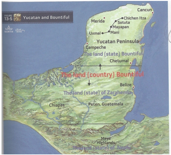
[9]. See Allen and Allen, Exploring the Lands of the Book of Mormon, 467, 307, 409, 476–77, and 615 where Joseph and Blake Allen explain that the three lands Bountiful are the country of Bountiful (the same as the greater land southward, including everything south of the Isthmus of Tehuantepec and including all the Nephite land southward of the narrow strip of wilderness); the state of Bountiful (a subdivision of the country of Bountiful like the state of the land of Zarahemla, the state of the land of Nephi, and the state of the land Bountiful being synonymous with the state of the east wilderness); and the city/land of Bountiful (a smaller subdivision of the state of Bountiful located on the east sea).The following map is located on page 307. Why is the west-sea land Bountiful missing? (Map used with the permission of Joseph Allen)
[10]. See Allen and Allen, Exploring the Lands of the Book of Mormon, 412.
[11]. See Ted Dee Stoddard, “‘If There Are Faults They are the Mistakes of Men’: The Nature of Mormon’s Word Processor,” http://www.bmaf.org/articles/mormons_word_processor__stoddard.
[12]. Richard F. Hauck, Deciphering the Geography of the Book of Mormon (Salt Lake City: Deseret Book Company, 1988), 32: “The text contains no reference to an intermediate Bountiful somehow linking the east sea and the west sea Bountifuls. These two coastal zones are separate and quite distinct from one another. Thus, the common notion that a single, all-encompassing Bountiful existed spanning the distance between the two seashores is not acceptable, for there are no supporting data for such an assumption.”
[13]. The description of this site and its population is according to Gareth Lowe, Thomas E. Lee, and E. Martinez Espinosa, Izapa: An introduction to the Ruins and Monuments (Provo, UT: Brigham Young University, 1982).
[14]. Richard Hauck states the following in an email to me dated April 29, 2012: “I think that Izapa was a place of refuge to them because of its historic significance and therefore, a year after the destructions associated with the Crucifixion, the remaining righteous Nephites returned to that place knowing that is where the Savior would come. An architectural analysis of Izapa demonstrates that site’s planning and construction as a sacred location in exact similitude of the temple site in Jerusalem only on a scale 15 times larger than was Solomon’s temple, Izapa’s prototype.”
[15]. Ted Stoddard explained this so very well in an email he sent me August 2, 2010:
For centuries, the most reasonable way to get from Chiapas or Guatemala to Veracruz, Oaxaca, or the Mexico valley was to end up on the Pacific coast and go north through the Isthmus of Tehuantepec. About fifty miles into the isthmus, the topography opens up, permitting travelers to continue to Veracruz or to follow trails into the mountains and thence to the Oaxaca or Mexico areas.
In a similar vein, travelers from the east wilderness (lowland jungle area of the Peten and Belize) or from the east sea (Caribbean off the coast of Belize) typically had a difficult time traveling due west to go through the top of the isthmus because of (1) the mountainous terrain, especially in the Hermounts region at the top of and east of the isthmus, or (2) the marshy lagoons and rivers of Tabasco that made east-west travel almost impossible until the arrival of modern highways.
[16]. I propose a serious look at the expression “land, or city Bountiful.” Is this a scrivener’s error as claimed by Magleby? Did Mormon make an incorrect engraving that he then had to correct? Or does the expression have a specific meaning of being the supporting area surrounding the named city?
These are very important questions, the answers to which will help in the determination of the size of the east-sea land Bountiful. I will explore these questions in depth.
On May 2, 2012, Kirk Magleby published an article on the Book of Mormon Archaeological Forum website about the great work of Royal Skousen regarding possible errors in the Book of Mormon, whether by transcription, translation, printing, or even in the original writing by the authors of the Book of Mormon. In most of his article, Magleby credits Royal Skousen’s critical text in support of the errors cited in Magleby’s article. However, in his following comment, he does not cite Skousen. Nonetheless, readers are given the impression that Skousen identified or supported a statement to the effect that Moroni was confused.
Magleby writes the following: “Even Mormon had trouble keeping everything straight in his mind all the time. In Alma 53:3 he engraved ‘the land,’ then corrected himself and because one can’t erase engravings on metal plates, said ‘or, the city, Bountiful.’ As verse 4 makes explicit, it was the city and not the entire land that was fortified. Mormon had previously temporarily confused the lands of Bountiful and Moroni (see Alma 50:32). The same thing happened in Alma 56:14 where Mormon engraved ‘the land of Manti,’ then corrected himself and said ‘or the city of Manti.’”
Perhaps in some cases there was an emendation, as Ted Stoddard proposes (see endnote 11). However, I personally believe that in most cases, the meaning of “land, or city” in the Book of Mormon was not a lapse of memory or confusion on Mormon’s part. The statement “land, or city of,” or similar language, was used by Mormon over twenty times. As will be shown hereafter, all of the following phrases clearly show that the authors’ intent was to include the supporting areas surrounding each city as part of the city area. Perhaps it is like one might have said, 150 years ago, “the city of Lehi including the farm lands around it,” or “the lands around American Fork,” or “the Alpine area” where initially there were no defined boundaries of a town or city. Remember that during the early years of Moroni’s command, they were just beginning to establish the east-sea coastal cities and their boundaries. Remember also the boundary dispute between Morianton and Lehi as an example.
The following twenty-four scriptures support the above understanding. See if you the reader think Mormon was confused or mistaken as to any of them:
Alma 56:14: The land of Manti, or the city of Manti, and the city of Zeezrom, and the city of Cumeni, and the city of Antiparah.
Alma 50:14: And they also began a foundation for a city between the city of Moroni and the city of Aaron, joining the borders of Aaron and Moroni; and they called the name of the city, or the land, Nephihah.
Alma 61:8: They [rebellious Nephites ca 62 BC] have got possession of the land, or the city, of Zarahemla; they have appointed a king over them, and he hath written unto the king of the Lamanites, in the which he hath joined an alliance with him; in the which alliance he hath agreed to maintain the city of Zarahemla, which maintenance he supposeth will enable the Lamanites to conquer the remainder of the land, and he shall be placed king over this people when they shall be conquered under the Lamanites.
Mosiah 7:1: And now, it came to pass that after king Mosiah had had continual peace for the space of three years, he was desirous to know concerning the people who went up to dwell in the land of Lehi-Nephi, or in the city of Lehi-Nephi; for his people had heard nothing from them from the time they left the land of Zarahemla; therefore, they wearied him with their teasings.
Alma 53:3: And it came to pass that after the Lamanites had finished burying their dead and also the dead of the Nephites, they were marched back into the land Bountiful; and Teancum, by the orders of Moroni, caused that they should commence laboring in digging a ditch round about the land, or the city, Bountiful.
Mosiah 7:21: And ye all are witnesses this day, that Zeniff, who was made king over this people, he being over-zealous to inherit the land of his fathers, therefore being deceived by the cunning and craftiness of king Laman, who having entered into a treaty with king Zeniff, and having yielded up into his hands the possessions of a part of the land, or even the city of Lehi-Nephi, and the city of Shilom; and the land round about—
All of the following scriptures clearly show that the term “land of” is intended to mean the supporting lands immediately surrounding the designated city and not a large chunk of real estate.
Mosiah 23:25: For behold, it came to pass that while they were in the land of Helam, yea, in the city of Helam, while tilling the land round about, behold an army of the Lamanites was in the borders of the land [this was a new small city with a population of about 450 souls].
Alma 16:2: For behold, the armies of the Lamanites had come in upon the wilderness side, into the borders of the land, even into the city of Ammonihah, and began to slay the people and destroy the city.
Alma 47:20: And it came to pass that Amalickiah marched with his armies (for he had gained his desires) to the land of Nephi, to the city of Nephi, which was the chief city.
Alma 49:13: For they knew not that Moroni had fortified, or had built forts of security, for every city in all the land round about; therefore, they marched forward to the land of Noah with a firm determination; yea, their chief captains came forward and took an oath that they would destroy the people of that city.
Mosiah 23:20: And it came to pass that they didmultiply and prosper exceedingly in the land of Helam; and they built a city, which they called the city of Helam.
Alma 58:33: But behold, we trust in our God who has given us victory over those lands, insomuch that we have obtained those cities and those lands, which were our own.
3 Nephi 3:6: Therefore I write unto you, desiring that ye would yield up unto this my people, your cities, your lands, and your possessions, rather than that they should visit you with the sword and that destruction should come upon you.
Alma 8:7: Now it was the custom of the people of Nephi to call their lands, and their cities, and their villages, yea, even all their small villages, after the name of him who first possessed them; and thus it was with the land of Ammonihah.
Alma 62:7: And it came to pass that Moroni and Pahoran went down with their armies into the land of Zarahemla, and went forth against the city, and did meet the men of Pachus, insomuch that they did come to battle.
Mormon 3:5: And it came to pass that I did cause my people that they should gather themselves together at the land Desolation, to a city which was in the borders, by the narrow pass which led into the land southward.
Alma 43:25: Now Moroni, leaving a part of his army in the land of Jershon, lest by any means a part of the Lamanites should come into that land and take possession of the city, took the remaining part of his army and marched over into the land of Manti.
Alma 8:18: Now it came to pass that after Alma had received his message from the angel of the Lord he returned speedily to the land of Ammonihah. And he entered the city by another way, yea, by the way which is on the south of the city of Ammonihah.
Mormon 4:19: And it came to pass that the Lamanites did come down against the city Desolation; and there was an exceedingly sore battle fought in the land Desolation, in the which they did beat the Nephites.
Alma 62:18: And it came to pass that when they had sent them away they pursued their march towards the land of Nephihah. And it came to pass that when they had come to the city of Nephihah, they did pitch their tents in the plains of Nephihah, which is near the city of Nephihah.
Alma 62:14: And it came to pass that Moroni and Pahoran, leaving a large body of men in the land of Zarahemla, took their march with a large body of men towards the land of Nephihah, being determined to overthrow the Lamanites in that city.
Alma 62:30: Now it came to pass that Moroni, after he had obtained possession of the city of Nephihah, having taken many prisoners, which did reduce the armies of the Lamanites exceedingly, and having regained many of the Nephites who had been taken prisoners, which did strengthen the army of Moroni exceedingly; therefore Moroni went forth from the land of Nephihah to the land of Lehi.
Mormon 4:2: And it came to pass that the armies of the Nephites were driven back again to the land of Desolation. And while they were yet weary, a fresh army of the Lamanites did come upon them; and they had a sore battle, insomuch that the Lamanites did take possession of the city Desolation, and did slay many of the Nephites, and did take many prisoners.
In most of these cases, the terms “city” alone refers to that specific city but when the term “land of” is used it gives rise to the concepts that (1) each city/land was not a huge area and (2) it did not overlap another adjoining “city or land of.” Therefore, the city/land of Bountiful was not a large area, and it did not overlap the city/land of Mulek some five miles or so distant.
Magleby also misunderstands Alma 50:32: “Mormon had previously temporarily confused the lands of Bountiful and Moroni [as shown in] Alma 50:32.” I submit that it is Magleby who is confused. As my daughter said, “A general does not confuse the lands he is protecting.” If Mormon was only temporarily confused, then he would have corrected it. Because he did not make the correction, was he then permanently confused? Impossible! This scripture is not talking about the land of Moroni. If it would have been, then surely Mormon would have said “land of Moroni.”
Now behold, the people who were in the land Bountiful, or rather Moroni, feared that they [the people who were in the land Bountiful] would hearken to the words of Morianton and unite with his people and thus he would obtain possession of those parts of the land, which would lay a foundation for serious consequences among the people of Nephi (Alma 50:32)
Think about it and apply what Magleby describes as “temporary confusion” on the part of Mormon and insert “land of Moroni” in the place of “land Bountiful” and what do you have?
The people who were in the land of Moroni feared that they (themselves?) would hearken to the words of Morianton and unite with his people.
What sense does that make? It is total confusion on Magelby’s part and not of Mormon. The people of Morianton were not going to the land of Moroni (which was located on the east-sea coast south next to the line of possessions of the Lamanites near the narrow strip of wilderness). They were bound for the Jaredite land northward (see Alma 50:34) to where many of the Nephites were beginning to migrate. To get to the Jaredite land northward, Morianton had to go through the west-sea land Bountiful. He certainly would not have traveled through the territory of the millions of Maya in Tikal, El Mirador, etc. Moroni was desperately trying to confine the Lamanites to the south of the narrow strip of wilderness and could not afford to have a dissident group of Nephites poison the minds and hearts of his Nephite people living in the west-sea land Bountiful. Thus, Morianton traveled toward—not in because they were stopped before they crossed the “line” between Desolation and Bountiful—the Jaredite land northward via the west-sea land Bountiful route. Mormon said what he meant without confusing the land Bountiful and the land of Moroni. Today, we might state the scripture as follows:
Moroni feared that the people who were in the land Bountiful would hearken to the words of Morianton and unite with his people and thus he [Morianton] would obtain possession of those parts of the land [being west-sea land Bountiful and/or the Jaredite land northward].
Mormon was not confused even temporarily. He did not have trouble keeping the geography straight. That he might have made an occasional error he admitted. This was not one of them. I submit that if he had made a “whoops,” as Joseph Allen and Ted Stoddard facetiously call it, then he corrected it—a process known as an emendation. Therefore, it would no longer have been a mistake. We must give it the meaning he intended and be sure that it is also consistent with all of the relevant scriptures.