


Response to Jonathan Neville’s The Lost City of Zarahemla
Response to Jonathan Neville’s The Lost City of Zarahemla
Jonathan Neville proposes[1] that the once-faithful, dynamic missionary and friend of Joseph Smith, Benjamin Winchester, was the author of the nine hundred editorial words contained in three articles in the September 15 and October 1, 1842, issues of Times and Seasons. These nine hundred editorial words identify Central America and Guatemala as the geographic area where the Book of Mormon took place. Even though he admits that this conclusion is based almost exclusively on circumstantial evidence, I found that the evidence was very informative, nicely presented, and plausibly accurate. Neville’s presentation met the prima facia threshold by a preponderance of the evidence. Perhaps there is another side of the story; however, for purposes of this article, I am willing to admit to the possibility that Benjamin Winchester probably wrote, or at least initiated and promulgated, the said nine hundred editorial words.
Having said that, I think that all three Prophets and Presidents of The Church of Jesus Christ of Latter-day Saints (Joseph Smith, John Taylor, and Wilford Woodruff) who had knowledge of and participated in the publishing of the Times and Seasons clearly never officially recanted, rejected, modified, or disputed those nine hundred editorial words.
Neville’s book reaffirms the conclusion—and all scholars and authors of Book of Mormon geography should now be in agreement with the fact—that neither Joseph Smith nor any other prophet has ever claimed to have received definitive revelation as to where the geography of the Book of Mormon took place. Had he done so, there would be no discussion today by those faithful in the Church. There would be no Lost City of Zarahemla. There would be no need to “decipher the geography of the Book of Mormon.[2] He did not know where it took place. Neville points out that “Joseph Smith never expressly embraced the hemispheric, Mesoamerican, or any other model.” However, as Neville also points out, “[Joseph] did occasionally comment about particular locations as being related to the Nephites and on several occasions he referred to North American Indian tribes as ‘Lamanites.’”[3]
I agree with the following facts and conclusions in Neville’s book:
-
That the lands of Desolation and Bountiful are not synonymous with the greater lands northward and southward, respectively, (see maps on pages 304, 332, and 333) but were relatively small subdivisions thereof.
-
That if the “head of river Sidon means the source of the river, then the river would have to flow north; i.e., from Manti north past Zarahemla” and could not flow south past the city/land of Nephi (page 314).
-
That the land of Zarahemla was located directly north of the land of Nephi and that both lands were divided by a narrow strip of wilderness (page 332).
-
That Manti was located south of Zarahemla between Nephi and Zarahemla (pages 313–314).
-
That the east sea was an ocean that was located to the east of the land of Zarahemla, east of the land of Nephi, and east of the narrow strip of wilderness (page 297).
-
That even though his map does not show it, Neville describes Desolation and Bountiful as “northward/southward of each other.” He says at page 304, “They are not due north or south of whatever Mormon is using as a reference point.”
-
That the “terms ‘up,’ ‘down,’ and’ ‘over’ in a geographical context refer to elevation” (page 311).
-
That the Book of Mormon uses cardinal directions: “What the Nephites called ‘east’ is what most human societies have always called ‘east;’ i.e., the direction in which the sun rises. The other cardinal directions, as used in the Book of Mormon, are the same as those in use today” (page 321).
However, many of the geographic conclusions proposed by Neville are not supported by Book of Mormon evidence, as will be discussed hereafter. And there can be no argument that all facts contained in the most correct book, the Book of Mormon, trump all other evidence, statements, and conclusions, including those of the Prophet Joseph Smith. Neville correctly states the following:
People respond to the truth. The more we learn about The Book of Mormon, the more the truth becomes apparent. A correct understanding of Book of Mormon geography and anthropology will facilitate acceptance of the book on a broader scale than ever before.[4]
However, Neville incorrectly states that “The ‘Mesoamericans’ rely initially on the 1842 Times and Seasons articles.”[5] The truth is that the Mesoamericans rely initially and primarily upon the evidence contained within the covers of the Book of Mormon. I will show evidence and truth from the Book of Mormon that will prove, not just by a preponderance of evidence but beyond any reasonable doubt, that the Book of Mormon does not support the proposition described in Neville’s book that all the events and geographic locations described in the Book of Mormon took place exclusively in the United States and Canada.
The geography of the Book of Mormon must be determined from within the pages of the Book of Mormon. Every relevant scripture must be studied with all other Book of Mormon scriptures as to where specific events took place and as to the spatial interrelationship of these events. Authors should not pick and choose which scripture supports their conclusions and leave out those that do not support it—such as Rod Meldrum does in refusing to identify and discuss the prophecy and promise of 1 Nephi 13:12, which clearly identifies “Columbus” and relates to the southern European Gentiles and their role in purging the “seed of thy brethren”—the Lamanites—in the areas of Central and South America.[6]
This article will discuss many foundational scriptures that have been excluded from consideration, or misstated, resulting in a wrong conclusion being drawn about where the narrow strip of wilderness must have been located and the nature of it. It will further prove that the river Sidon must flow north. Other omissions will also be cited and discussed. For convenience and accessibility, all Book of Mormon scriptures will be italicized, and other emphasis will be via bolding by the author.
It seems apparent that the foundational geographic differences between the Mesoamericanists and the North Americanists are twofold: (1) the nature and location of the narrow strip of wilderness and (2) the direction of flow of the river Sidon.
Therefore, according to the Book of Mormon, if the narrow strip of wilderness was mountainous and ran from a west sea to an east sea and if the river Sidon flowed north, then the Heartland Model is false. Conversely, if the narrow strip of wilderness was not mountainous and if the Sidon flowed south, then the Mesoamerican Model is false. It is that simple, and Neville agrees with this premise (page 314 and by personal conversation).
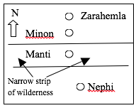
As readers consider the following Book of Mormon criteria, they should keep in mind the following directional orientation from Zarahemla on the north to Nephi on the south:
- Zarahemla on the north of the narrow strip of wilderness
- Minon south of Zarahemla
- Manti south of Minon and within the narrow strip of wilderness
- Nephi south of Manti and south of the narrow strip of wilderness
The Nature of the Narrow Strip of Wilderness
All the relevant facts pertaining to the narrow strip of wilderness must be disclosed if analysts are to understand its nature, where it was located, and, for purposes of this response, where it could not have been located. The Book of Mormon requires that the narrow strip of wilderness meet all the following criteria:
- It ran from “the sea east even to the sea west,” the referent being the city/land of Nephi where the Lamanite king lived and sent out his proclamation (Alma 22:27–28).
o A sea in the Book of Mormon is always used in its literal sense as defined in the 1828 Webster’s dictionary as a large body of water connected to an ocean and of the same level.[7]
o The west sea was located west of the land of Nephi, west of the land of Zarahemla, and west of the west end of the narrow strip of wilderness. (Alma 22:28)
o The east sea was located east of the land of Nephi, east of the land of Zarahemla, and east of the east end of the narrow strip of wilderness.[8]
-
It divided the land of Nephi from the land of Zarahemla (Alma 22:27).
-
It ran “in a straight course from the east sea to the west [sea]” (Alma 50:8–11). If the land of Nephi ran in a straight course from the east sea to the west sea, then the narrow strip of wilderness did not curve in a circle but continued from the same sea east to the same sea west that defined the land of Nephi, in a straight or perhaps “direct” course.
-
It was within which Moroni established the military defensive “line” [ca. 72 BC]: “And thus he cut off all the strongholds of the Lamanites in the east wilderness, yea, and also on the west, fortifying the line between the Nephites and the Lamanites, between the land of Zarahemla and the land of Nephi, [the line going] from the west sea running by the head of the river Sidon—the Nephites possessing all the land northward [of the line] yea, even [possessing] all the land which was northward of the land Bountiful [being Desolation and the Jaredite land northward], according to their pleasure.” (Alma 50:11; emphasis added)
-
It supported a military defensive line dividing the Nephites on the north from the Lamanites on the south (Alma 22:33–34, Helaman 4:7–8). This line of defense was effective only from 72 BC to 35 BC, a period of less than thirty-seven years when the Lamanite and Nephite dissenters joined forces and conquered all the land of Zarahemla, thus destroying the effectiveness of the defensive narrow strip of wilderness. (Helaman 4:8)
-
It must be surrounded by evidence of “many cities” that existed between about 200 BC and AD 400 and in which a written language was used as documented in the books of Omni to Mormon: Zarahemla, Gideon, Melek and Ammonihah on the north; Nephi, Shilom, Shemlon, Ishmael, etc. on the south; Nephihah, Moroni, Jershon, etc. on the east; and Cumeni, Antiparah, Judea, etc. on the west. Manti was located right in the middle, up in elevation and southerly from Gideon and Minon and up farther southward near but northward from the head of the river Sidon. (Alma 22:27).
-
It was mountainous; therefore, the river Sidon flowed north. The following is a sampling, in chronological order, of the many scriptures indicating that the narrow strip of wilderness was mountainous, meaning that Gideon, Minon, Manti, the head of river Sidon, city/land of Nephi, and the entire narrow strip of wilderness were all higher in elevation than Zarahemla—conclusively proving that the river Sidon had to have flowed north and not south. These scriptures also prove that the areas where the majority of the Lamanites and Nephites resided were located very near—if not within—mountains:
o Ca. 200 BC, Omni and Mosiah state: “He [Mosiah] did according as the Lord had commanded him. And they departed out of the land [of Nephi] into the [narrow strip of] wilderness (Omni 1:13) [and thence up to] the hill north of the land of Shilom, which had been a place of resort for the children of Nephi at the time they fled out of the land” (Mosiah 11:13). [Then Omni 1:13 continues] “through the [narrow strip of] wilderness until they came down into the land which is called the land [or city] of Zarahemla.” [The area south of Zarahemla was higher in elevation than Zarahemla. Until about 124 BC, the city and the land of Zarahemla—to which Mosiah came down—could not have encompassed an area greater than about the size of the Salt Lake Valley; therefore, the narrow strip of wilderness was very visible from Zarahemla.][9]
o Ca. 200 BC: King Noah “caused a great tower to be built on the hill north of the land Shilom, which had been a place of resort [gathering place] for the children of Nephi at the time they fled out of the land [of Nephi]” (Mosiah 11:13; emphasis added). [The area north of the land of Nephi was higher in elevation than Nephi.]
o 87 BC: The spies of Alma said that “we followed the camp of the Lamanites and to our great astonishment, in the land of Minon, above the land of Zarahemla, in the course of [southerly toward] the land of Nephi . . . the Amlicites have joined them [Lamanites]” (Alma 2:24; emphasis added). [Therefore, because Nephi was higher in elevation[10] than Zarahemla; Minon was also higher than Zarahemla; Minon was in the pathway to Nephi; and because Manti was also in that pathway and was located south of Minon and within the narrow strip of wilderness, then Manti also must have been higher in elevation than Zarahemla.]
o About 85 BC: The borders of (or the defensive line) went “through the borders of Manti by the head [beginning] of the river Sidon” (Alma 22:27; emphasis added). [Webster’s 1828 dictionary defines head as “The principal source of a stream; as the head of the Nile.”]
o 81 BC: Alma told Captain Zoram where to find the Nephite captives taken from the city of Noah: “Alma returned and said unto them: Behold the Lamanites will cross the river Sidon in the south wilderness [southern part of the narrow strip of wilderness], away up beyond the borders of the land of Manti. And behold there shall ye meet them, on the east of the river Sidon.” (Alma 16:6; emphasis added) [Therefore, the place where they crossed the Sidon was south of Manti, and it was higher than Manti. The river Sidon must have been shallow enough for the Lamanites to have crossed on foot. The river Sidon must flow north.]
o About 77 BC: The Ammonites, camping near Manti, received word they would be going eastward down to Jershon: “Behold, we will give up the land of Jershon, which is on the east by the sea. . . . And it came to pass that it did cause great joy among them. And they went down into the land of Jershon.” (Alma 27: 22, 26; emphasis added) [Thus, the eastern part of the narrow strip of wilderness was higher than the land of Jershon.]
o 74 BC: “[Moroni] concealed [the rest of his army] in the west valley, on the west of the river Sidon, and so down into the borders of the land Manti.” (Alma 43:32; emphasis added) [This was the second battle within the narrow strip of wilderness south of Manti near the head of Sidon (Alma 16:6). Therefore, the valley of Manti was lower in elevation than the head of the river Sidon.[11] Thus, the river Sidon must flow north.]
o 72 BC: “Now we will return in our record to Amalickiah and those who fled with him into the [narrow strip of] wilderness; for, behold, he had taken those who went with him, and went up [south from Zarahemla] in the land of Nephi among the Lamanites.” (Alma 47:1; emphasis added) [The area south of Zarahemla, including Minon, Manti, and the land of Nephi, were all higher in elevation than Zarahemla.]
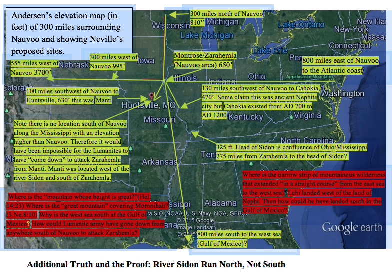
o 64 BC: “[The Lamanites had captured Manti and considered their next city to conquer from Manti; however,] neither durst they march down [north] against the city of Zarahemla; neither durst they cross the head of Sidon [which also must have been up in elevation from Zarahemla], over [east] to the city of Nephihah (Alma 56:25; emphasis added), [which was located eastward near the city of Moroni, which was located near the east sea. This would have been the same crossing referenced in Alma 16:6 and Alma 43:32.”] [As a geographic side note at this point, I invite readers to think about the following: If the Heartland Model is correct, then the Lamanites would have to have gone from Huntsville, Missouri, (Meldrum’s Manti) and then cross the Mississippi south of Nauvoo (Meldrum’s “head of Sidon”), and then over eight hundred miles to near the Atlantic coast (Neville’s east coast) to attack Nephihah? I don’t think so!] [This scripture further proves that Manti was located higher in elevation than Zarahemla.]
o 63 BC: Helaman and his sons had taken many prisoners from near the west sea and from the city of Cumeni—located within the narrow strip of wilderness—and had decided to “guard them, sword in hand, down to the land of Zarahemla. . . . We did resolve to send them down to the land of Zarahemla . . . and gave them charge over our prisoners to go down to the land of Zarahemla.” (Alma 57:15–16; emphasis added) [The area of the narrow strip of wilderness near the west sea was also higher in elevation than Zarahemla.]
o 61 BC: “Moroni and Pahoran went down with their armies [from Gideon] into the land of Zarahemla.” (Alma 62:7; emphasis added) [Because both Minon and Gideon were higher in elevation than Zarahemla, because they were only about five miles apart, and because the river Sidon ran between them, then it must have flowed from there as it went down in elevation and north past Zarahemla.] [12]
o 12 BC: Nephite and Lamanite dissenters converted to become Gadianton robbers: “And they did commit murder and plunder; and then they would retreat back into the mountains, and into the wilderness and secret places, hiding themselves that they could not be discovered, receiving daily an addition to their numbers, inasmuch as there were dissenters that went forth unto them.” (Helaman 11:25; emphasis added; see also 3 Nephi 1:27) [Therefore, the mountains were located in close proximity to the population areas of both the Nephites and the Lamanites, and thus the narrow strip of wilderness between the land of Nephi and the land of Zarahemla was mountainous and was the area where the Gadianton robbers secreted themselves.]
o 12 BC: “And the robbers did still increase and wax strong, insomuch that they did defy the whole armies of the Nephites and also [the armies] of the Lamanites, and they did cause great fear to come unto the people upon all the face of the land.” (Helaman 11:32) [The dissident Nephite and Lamanite robbers were hiding within the narrow strip of wilderness because they were affecting the people and proselytizing among both the Lamanites and the Nephites.]
o 11 BC: “[The] robbers did make great havoc, yea, even great destruction among the people of Nephi and also among the people of the Lamanites. . . . Therefore they sent an army . . . into the wilderness and upon the mountains to search out this band of robbers. . . . [The Nephites and Lamanites were] obliged to return out of the wilderness and out of the mountains unto their own lands, because of the exceeding greatness of the numbers of those robbers who infested the mountains and the wilderness.” (Helaman 11:28, 31; emphasis added) [Because the robbers were bothering both the Lamanites and the Nephites and because the closest mountains to both of these lands were located within the narrow strip of wilderness between these two lands, then the narrow strip of wilderness must have been mountainous.]
o AD 3: “And it came to pass that the ninety and third year did also pass away in peace, save it were for the Gadianton robbers, who dwelt upon the mountains, who did infest the land; for so strong were their holds and their secret places that the people could not overpower them; therefore they did commit many murders, and did do much slaughter among the people.” (3 Nephi 1:27) [The Gadianton robbers must have lived in the vicinity of both the Nephites and Lamanites; therefore, the mountains must have been located between the land of Nephi and the land of Zarahemla, which by definition was the narrow strip of wilderness. There are no mountains within three hundred miles of both Huntsville, Missouri, and Nauvoo.]
o AD 13: “And it came to pass in the thirteenth year there began to be wars and contentions throughout all the land [of the Nephites and the Lamanites]; for the Gadianton robbers had become so numerous, and did slay so many of the people, and did lay waste so many cities, and did spread so much death and carnage throughout the land, that it became expedient that all the people, both the Nephites and the Lamanites, should take up arms against them.” (3 Nephi 2:11; emphasis added) [Clearly, the area where these robbers lived was within the narrow strip of wilderness between Nephi and Zarahemla.]
o AD 14: “And it came to pass in the commencement of the fourteenth year, the war between the robbers and the people of Nephi did continue and did become exceedingly sore; nevertheless, the people of Nephi did gain some advantage of the robbers, insomuch that they did drive them back out of their lands into the mountains [in the narrow strip of wilderness between the lands of Nephi and Zarahemla] and into their secret places.” (3 Nephi 2:17; emphasis added)
o AD 17: Lachoneus prepared against the time when the “robbers should come down out of the [narrow strip of] wilderness against them.” (3 Nephi 3:17; emphasis added).
o AD 17: The people requested, “Let us go up upon the mountains and into the wilderness that we might fall upon the robbers and destroy them.” (3 Nephi 3:20; emphasis added) [Lachoneus advised against the people’s request that they go on the offensive against the robbers in the mountains up in their own lands instead of down in the city/land of Zarahemla]. [Book of Mormon analysts should have no doubt that the narrow strip of wilderness was mountainous.]
o AD 18: “[The] robbers had prepared for battle, and began to come down and sally forth, from the hills, and out of the mountains . . . and began to take possession of the lands, both which were in the land south [of the narrow strip of wilderness] and which were in the land north[13] [of the narrow strip of wilderness], and began to take possession of all the lands which had been deserted by the Nephites [including the Lamanites], and the cities which had been left desolate.” (3 Nephi 4:1; emphasis added) [This is more clear evidence that the narrow strip of wilderness was mountainous.]
o Clearly, the Gadianton robbers were infesting the mountains between the land of Nephi and the land of Zarahemla within the narrow strip of wilderness. (3 Nephi 2:11–17; 4:1; 3:17–20)
Look at the following map showing the elevations and distances of pertinent locations proposed along the Mississippi River. There is no place within three hundred miles on either side of the Mississippi River where all these events could have taken place. Clearly, the term “head of river Sidon” is referring to the beginning or source of the river Sidon; therefore, as stated by Neville, the Mississippi River could not have been the river Sidon.
For purposes of this map, the area of Zarahemla across from Nauvoo will be referred to as Nauvoo for ease of reference and recognition for the reader.
Jonathan Neville correctly states the following:
The disagreement between the Mesoamerican and Heartland advocates revolves largely around the meaning of the phrase “head of the Sidon,” which is mentioned in connection with both Manti and Nephihah. If “head of the river Sidon” means the source of the river, then the river would have to flow north: i.e., from Manti north past Zarahemla. This interpretation also means the river could not flow through the land of Nephi.[14]
In addition to the fact that the narrow strip of wilderness was mountainous and that the “head of river Sidon” is described in the Book of Mormon as the beginning of the Sidon up in the narrow strip of wilderness—rather than the confluence of major rivers as suggested by Rod Meldrum and Jonathan Neville—the following scenario from the Book of Mormon further forecloses any possibility that the Mississippi River could have been the river Sidon.
In 74 BC, Moroni was appointed chief captain of the Nephite armies. He was stationed on the east seacoast preparing for war with the Nephite dissenters and the Lamanites—including the Zoramites at Antionum, who had become Lamanites—in the east-sea area. Because the mostly naked Lamanites feared the armaments, breastplates, etc. of the Nephites, the Lamanites feared to go against them in the land of Antionum, and their leader Zerahemnah decided to go into the narrow strip of wilderness and “up” (see Alma 43:34) to the area of the head of river Sidon and then to proceed down northward to the land of Manti to attack the weaker Nephites in that area.
Moroni, with the help of spies and prophetic advice from Alma, arrived in the area first and secreted his armies in a valley in which the river Sidon flowed. Readers should remember, and Neville admits on his maps, that the directional relationship was from Zarahemla south to Minon, then south to Manti, then south to the head of Sidon, and then south to the land of Nephi. It is the elevation relationship that must be deciphered from the Book of Mormon. Readers should also ponder and ask how the following events could have occurred along the Mississippi in the area Neville and Meldrum propose as the “head of Sidon”—the confluence of the Ohio and Mississippi Rivers:
22. Behold, now it came to pass that they durst not come against the Nephites in the borders of Jershon; therefore they departed out of the land of Antionum into the [narrow strip of] wilderness, and took their journey round about in the [narrow strip of] wilderness, away by the head of the river Sidon, that they might come into the land of Manti and take possession of the land; for they did not suppose that the armies of Moroni would know whither they had gone. . . .
24. And it came to pass that the word of the Lord came unto Alma, and Alma informed the messengers of Moroni, that the armies of the Lamanites were marching round about in the wilderness, that they might come over [the head of river Sidon (see Alma 56:25)] into the land of Manti, that they might commence an attack upon the weaker part of the people. . . .
27. And it came to pass that Moroni caused that his army should be secreted in the valley which was near the bank of the river Sidon, which was on the west of the river Sidon in the wilderness.
28 And Moroni placed spies round about, that he might know when the camp of the Lamanites should come. . . .
31. Therefore, he divided his army and brought a part over [east of river Sidon] into the valley, and concealed them on the east [of Sidon], and on the south of the hill Riplah; [the valley of Manti was located in the narrow strip of wilderness and north of the head of Sidon]. [Hill Riplah was located near the east bank of Sidon.]
32. And the remainder he concealed in the west valley, on the west of the river Sidon, and so down into the borders of the land Manti [therefore, not only was Manti located on the west of Sidon but also it was lower in elevation than the head of Sidon]. [This scripture requires that the river Sidon flowed northward from its head down to the land Manti.] . . .
34. And it came to pass that the Lamanites came up on the north of the hill, where a part of the army of Moroni was concealed.
35. And as the Lamanites had passed the hill Riplah, and came [down] into the valley, and began to cross the river Sidon, [near its head as prophesied by Alma] the army which was concealed on the south of the hill, which was led by a man whose name was Lehi, and he led his army forth and encircled the Lamanites about on the east in their rear.
36. And it came to pass that the Lamanites, when they saw the Nephites coming upon them in their rear, turned them about and began to contend with the army of Lehi.
37. And the work of death commenced on both sides, but it was more dreadful on the part of the Lamanites, for their nakedness was exposed to the heavy blows of the Nephites with their swords and their cimeters, which brought death almost at every stroke. . . .
39. And it came to pass that the Lamanites became frightened, because of the great destruction among them, even until they began to flee [west] towards the river Sidon.
40. And they were pursued by Lehi and his men; and they were driven by Lehi into the waters of Sidon, and they crossed the waters of Sidon. And Lehi retained his armies upon the [east] bank of the river Sidon that they should not cross.
41 And it came to pass that Moroni and his army met the Lamanites in the valley, on the other side [west] of the river Sidon, and began to fall upon them and to slay them.
42. And the Lamanites did flee again before them, [down, see verse 32] towards the land of Manti; and they were met again by the armies of Moroni. [Manti was clearly lower than where they crossed near the head of Sidon.] . . .
50 And they began to stand against the Lamanites with power; and in that selfsame hour that they cried unto the Lord for their freedom, the Lamanites began to flee before them; and they fled [east] even to [not in] the waters of Sidon.
51 Now, the Lamanites were more numerous, yea, by more than double the number of the Nephites; nevertheless, they were driven insomuch that they were gathered together in one body in the valley, upon the [west] bank by the river Sidon.
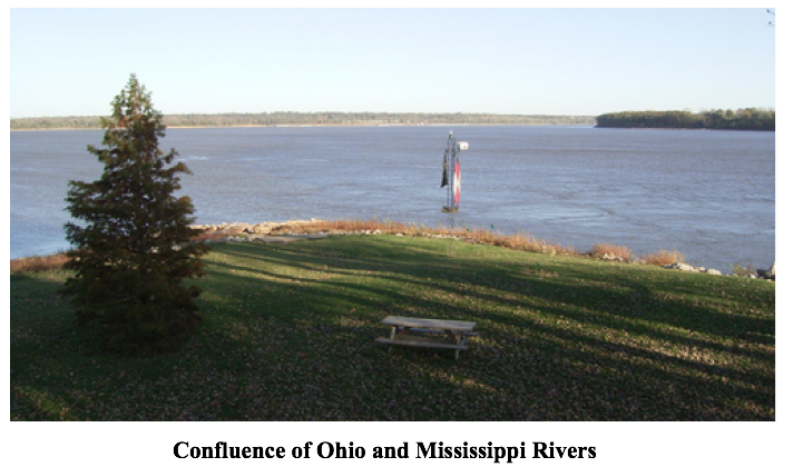
52 Therefore the armies of Moroni encircled them about, yea, even on both sides of the river, for behold, on the east were the men of Lehi. [The river Sidon must have been very narrow and shallow at that point near the head of Sidon for the Lamanites to have felt like they were “encircled about” and to so easily have crossed on foot with their entire army.] [This could not have happened anywhere near the confluence of the Ohio and the Mississippi Rivers (see photo below).]
53 Therefore when Zerahemnah saw the men of Lehi on the east of the river Sidon, and the armies of Moroni on the west of the river Sidon, that they were encircled about by the Nephites, they were struck with terror.
54 Now Moroni, when he saw their terror, commanded his men that they should stop shedding their blood. (Alma 43:20–54; emphasis added)
The truth as contained in the Book of Mormon is that the river Sidon in the area of this battle in the year 74 BC was a relatively small river that the armies could cross easily and quickly on foot. Zerahemnah and his army would have crossed it twice in one day but for the fact that he saw Lehi and his army standing on the east bank of Sidon.
In one day, Zerahemnah had come down with his army from the head of Sidon into the valley, fought Lehi on the east bank of Sidon, crossed the river, fought Moroni on the west bank of Sidon, fled down north toward Manti in the valley of Manti, and engaged in battle the third time—where he was “met again by the armies of Moroni.” The fighting stopped for a while, and Moroni tried to negotiate a peace with Zerahemnah. This failed, and the battle continued until Zerahemnah finally gave up.
How could all of these events have happened anywhere near the Mississippi—especially at or near the confluence of the Ohio and/or Missouri and Mississippi Rivers? How could the events have happened in one day unless the river Sidon was very small and shallow as it was near its beginning?
The following comments seem repetitious but necessary and are specifically what is required by the Book of Mormon. One route between Zarahemla and Nephi went northerly from Nephi up to the hill north of Shilom, then through the narrow strip of wilderness to the head of Sidon, then down northward to the valley of Manti, then northward down to Minon and then northward down to Zarahemla. The other route went from Zarahemla east across the river Sidon, then southerly up to Gideon, then southerly up to Manti, and then southerly up to the head of river Sidon,[15] then through the narrow strip of wilderness to the hill north of Shilom, and then southerly down to Nephi.
The distance between Gideon and Minon was less than a half night’s march at night—four or five miles—and the river Sidon ran right between them. The tired Amlicite remnant-army crossed the Sidon from Gideon to Minon at night, joining the Lamanites about midnight at Minon. Moroni’s scouts, following the Amlicites, crossed the river Sidon twice at night within twelve hours in that same area between Gideon and Minon (Alma 2:22–27). The river Sidon was still relatively small and shallow at that area; therefore, it could not have been at the confluence of the Ohio and Mississippi Rivers. There is no possible way that the Amlicite army and Moroni’s scouts could have crossed the Mississippi River south of Zarahemla—Montrose/Nauvoo area—let alone that Moroni’s scouts could have crossed it twice in one night!
There is not one piece of information in the Book of Mormon to indicate that the river Sidon flowed south from Zarahemla or that Manti was located lower in elevation than Zarahemla. Rod Meldrum disagrees, without citing a single scripture in support, saying:
To recap: The Sidon River in the Book of Mormon flowed past Zarahemla southward and “down” toward Manti which was at the head or confluence. . . . The “headwaters” could refer to the confluence of present day Missouri [Ohio] and Mississippi rivers.[16]
To come to this flawed conclusion, Meldrum must misconstrue or misstate what the Book of Mormon actually says and means as stated above. Neither Meldrum nor Neville cite any scriptures supporting their erroneous conclusions that Sidon flowed south or that it flowed down from Zarahemla toward Manti.
In a vain attempt to support Meldrum’s unsupportable conclusion that Mormon meant that the “head of Sidon” referred to the confluence of the Missouri or Ohio rivers with the Mississippi Rivers, Neville makes the following incredibly erroneous statement:
However, Alma 56:25 refers to a problem [false] crossing the head of Sidon. “Neither durst they march down against the city of Zarahemla neither durst they cross the head of Sidon over to the city of Nephihah.” Consequently, the “head of Sidon” must have been a significant feature. We can’t tell whether the Lamanites avoided [false] crossing the head of Sidon because of an inherent difficulty [false] or because of strategic fears [false], but the many other references to crossing don’t mention the head of Sidon [false]. A reasonable inference is that the “head of Sidon” was either fortified [false] as part of the border [false] or was an especially impassable section of the river border [false].[17]
As shown in the scriptures cited above, the head of river Sidon was very easy to cross; Moroni and his army crossed it twice in one day; Zerahemnah and his huge army—without any fear at all—would have crossed it twice that same day but for the fact that he saw Lehi standing on the east bank of the river, and he also saw that he was “encircled about by Nephites.” There is no evidence that this area was fortified at that time or that it was a border. The narrow strip of wilderness, running in an east-to-west direction, was the defensive “line,” not the river Sidon. Pray tell where is the “inherent difficulty” or the “especially impassable section” in crossing the head of river Sidon? Neville is trying to make his readers believe that that “inherent difficulty” and the “especially impassable section” was the confluence of the Ohio River with the Mississippi River. That dog won’t fly.
In fact, nowhere in the United States area can all the Book of Mormon requirements as cited above be met. The head or beginning of Sidon was located above Manti. It was so shallow and narrow that both armies could cross it twice in the same day on foot. The River Sidon ran north, not south.
The truth and the proof, from the Book of Mormon, are that the Mississippi is not, was not, and could not have been the river Sidon. Therefore, the Heartland Model is fatally flawed!
Can anyone legitimately believe the following as stated in The Lost City of Zarahemla:
-
That the narrow strip of mountainous wilderness from the east sea to the west sea (1) could have been over eight hundred miles long, extending from the Atlantic to beyond Nauvoo? or (2) could have extended from the New York City area south to Neville’s “west sea” at the Gulf of Mexico?
-
That if the Gulf of Mexico were the west sea and the Atlantic were the east sea, then the city Bountiful was located on the east sea—perhaps in the New York area—and could have been located more than eight hundred miles from the city/land Zarahemla?
-
That the Lamanite land of Nephi could have extended from about New York to New Orleans (from the east sea to the west sea as required by the Book of Mormon)?
-
That Hagoth built his ships on the shores of the Gulf of Mexico and then sailed them from there in a “course northward?”
-
That Moroni could have created a defensible military division line (from the east sea to the west sea) from New York to New Orleans?
-
That Moroni could have sent all the Lamanites (Mounds people?) living north of that military line to the south of that line?
Where within three hundred miles of the Mississippi River is there a “Mountain whose height is great”? (Helaman 14:23). Or where is there the “great mountain” that replaced the city of Moronihah? (3 Nephi 8:10).
If the west sea were the Gulf of Mexico, how could Hagoth have sailed from the Gulf of Mexico and taken his course “northward” as required by the Book of Mormon?
Hagoth built his ships on the shores of the west sea within the land Bountiful. How is that possible if Bountiful were located north of Nauvoo?
And it came to pass that Hagoth, he being an exceedingly curious man, therefore he went forth and built him an exceedingly large ship, on the borders of the land Bountiful, by the land Desolation, and launched it forth into the west sea, by the narrow neck which led into the land northward.
And behold, there were many of the Nephites who did enter therein and did sail forth with much provisions, and also many women and children; and they took their course northward. And thus ended the thirty and seventh year.
And in the thirty and eighth year, this man built other ships. And the first ship did also return, and many more people did enter into it; and they also took much provisions, and set out again to the land northward. (Alma 63:5–7; emphasis added)
Where is the west sea that borders Desolation and Bountiful? Where is the “narrow neck” or “narrow pass” that led by the west sea into the land northward? How could they have taken their course northward from the Gulf of Mexico? And, according to Neville’s maps, why is there no sea available northward from the land Bountiful? Readers should remember that Desolation was adjacent to, and northward, not north, from Bountiful. And readers should also remember that the definition of “sea” requires it to be the same level as the ocean.
Because the Book of Mormon describes the land Desolation as “being so far northward that it came into the land which had been peopled and been destroyed” (the Jaredite land northward), then, according to Neville’s maps, the land northward must have been north of Lake Michigan and north of Lake Huron. Because Cumorah was the same place where the Jaredites were destroyed, then Cumorah must have been located in Canada instead of near Palmyra.
Where in Neville’s map or geography is the required “line,” aka treaty line, between Desolation and Bountiful, which line began on the west sea and extended about fifteen miles eastward, as mandated by the Book of Mormon? There is only one “west sea” identified in the Book of Mormon. In the Heartland Model, therefore, either the west sea is the Gulf of Mexico as claimed by Neville or it is Lake Michigan as claimed by Meldrum. It cannot be both. And both are impossible according to the Book of Mormon.
Where is the “small neck of land” between the land northward and the land southward within which must be located the “line” between Desolation and Bountiful?
Readers should look at all the events that had to have taken place near this “line” that started on the west sea and extended “only the distance of a day and a half’s journey for a Nephite” as required by the Book of Mormon. Readers should ask for each of the following, Where could these events possibly have happened in the United States, let alone in the northern United States?
The “Line”/Treaty Line of AD 350: Its Nature and Paramount Geographic Importance
Understanding the nature of the “line” between Desolation and Bountiful is central and controlling for Book of Mormon readers who are trying to comprehend the geography of the Book of Mormon—especially as they attempt to locate the “small neck of land.” Following are all the Book of Mormon references and associated events that geographically relate to that “line:”
-
It began on the west sea and ran eastward a distance of “only the distance of a day and a half’s journey”—about fifteen miles or so (Alma 22:31–33; emphasis added).
-
It never bordered any other sea.
-
It was located northward from Joshua, which was also located near the west sea (Mormon 2:6).
-
It divided Desolation from Bountiful, both of which also began on the west sea (Alma 22:31–33).
-
The “line” was not the same thing as the “narrow neck of land” or “small neck of land.” or the pass, passage, or narrow neck as discussed above because the line led only eastward from the west sea fifteen miles or so to an undisclosed, identifiable geographical feature.
-
It was not the same as the two passes, the passage, or the narrow neck, all of which did not divide anything but each of which led into the lands northward/southward:
o “the narrow pass which led by the [west] sea into the land northward” (Alma 50:34).
o “the narrow pass which led into the land southward” (Mormon 3:5).
o “the narrow passage which led into the land southward” (Mormon 2:29.
o “the narrow neck which led into [did not divide] the land northward” (Alma 63:5).
-
It did not lead into Desolation or Bountiful because the “line” went from the west sea eastward “only the distance of a day and a half’s journey” to some identifiable landmark—not a sea but probably the Sierra Madre Mountains. Desolation was located, not north or east, but northward from that line. Bountiful was located, not south or west, but southward from that line (Helaman 4:6–7).
-
Desolation was part of the Jaredite land northward beginning at the “line” (Alma 22:32).
-
Bountiful was a part of the Nephite land southward, and it began at the same “line” (Alma 22:32).
-
It was the Jaredite entrance or gate into the land southward. “And they did preserve the land southward for a wilderness, to get game. And the whole face of the land northward [from the line] was covered with inhabitants.” Lib built his city by the entrance [“line”] into the land southward to preserve the land Bountiful (Alma 22:31) “to hunt food for the people of the land” (see Ether 10:19–22). The dividing “line”—as opposed to a pass or passage leading into something—between the land northward/southward was always the same “line” that separated Desolation from Bountiful because the line was located within the “small neck of land” that was located between the lands northward/southward.
-
It was the area where Morianton was stopped and killed by Teancum ca. 67 BC “by the borders of the land Desolation . . . by the sea on the west” (Alma 50:33–36).
-
It was the area where Moronihah, son of Captain Moroni, took refuge with his armies for two years, ca. 35 BC, while the Lamanites controlled all the land southward, including Zarahemla and all the east-sea locations. “The armies of Moronihah were driven even into the land of Bountiful” (Helaman 4:5–10).
-
It was the defensive line or a strategic feature that Moronihah “did fortify against the Lamanites from the west sea even unto the east: it being a day’s journey for a Nephite, on the line which they had fortified and stationed their armies to defend their north countries” (Helaman 4:7; emphasis added). [This “line” clearly ran almost perpendicular to the west sea and surely not parallel to the west sea because Moronihah used the “line” to block the transportation corridor.]
-
It was near where Lachoneus and his people (together with the Lamanite and Nephite armies (3 Nephi 3:14) took refuge for eight years (3 Nephi 6:1) while the Gadianton robbers controlled all of the land southward, ca. AD 17–26 “yea, to the line which was between the land Bountiful and the land Desolation” (3 Nephi 3:22–26, 4:1–5).
-
It was near where Hagoth built and sailed his ships in the years ca. 55–54 BC “on [within] the borders of the land Bountiful by [but not in] the land Desolation, and launched it forth into the west sea” (Alma 63:4–10).
-
It was the treaty “line” of AD 350, which treaty gave the Lamanites/robbers all the land southward, including the passage that led into the land southward (Mormon 2:29).
-
It was the same “line” from which the treaty gave the Nephites all the land northward, from the “line” where “the narrow passage which led into the land southward” began (Mormon 2:28–29).
-
It was near and to the south of the place where the “sea divides the land” (Ether 10:19–21) because it was located near the entryway into the land southward, which entryway was always located at the “line.”
-
The length of the line—“from the east to the west sea” in Alma 22:32—was “only” about fifteen miles or so. This was also the approximate width of the small or perhaps the narrow neck of land. This was also the approximate distance as the width of the west-sea land Bountiful, which was “inhabited,” according to Alma 22:33, “even from the east to the west sea.” Readers should notice that it does not say that the land Bountiful was inhabited from the east sea to the west sea—a distance of about 250 air miles. And readers should notice also that this inhabitation was exclusively by the Nephites because after 72 BC, to which this event is referencing, “all” of the Lamanites had been chased to the south of the narrow strip of wilderness (Alma 22:34).
-
It was the defensive area near, and to the south of, where the city Desolation was located, where the Lamanites, between AD 360 to AD 375, took fifteen years and five major assaults to permanently force Mormon and the Nephites out of Desolation northward to Jashon/Jordan (the Chivela Pass area) in the year AD 375 (Mormon 3–4).
-
It was also near the place where the Nephites beat the Lamanites in AD 362 and dumped their dead bodies into the west sea (Mormon 3:8).
These events were not happening within the confines of the United States of America. They also were not happening within the Isthmus of Tehuantepec but adjacent to it within the west-sea Bountiful area, and within the city Desolation area located within the southwest border area of Desolation. None of these events and locations could possibly have been associated with the Gulf of Mexico area either.
The Book of Mormon requires that the narrow strip of wilderness was mountainous; that Manti, Gideon, Minon, and the head of Sidon were higher in elevation than Zarahemla; and that the head of Sidon was the source of the river and not the confluence of the Ohio River with the Mississippi River. Thus, beyond any reasonable doubt, the river Sidon must flow north. Therefore, the Heartland Theory is fatally flawed.
Notes
[1]. Jonathan Neville, The Lost City of Zarahemla: From Iowa to Guatemala—and Back Again (Rochester, NY and Cottonwood Heights, UT: Legends Library Publishing, 2015).
[2]. See Richard Hauck, Deciphering the Geography of the Book of Mormon (Salt Lake City: Deseret Book, 1988).
[3]. Neville, The Lost City of Zarahemla, 266 and 265.
[4]. Neville, The Lost City of Zarahemla, 357.
[5]. Neville, The Lost City of Zarahemla, 267.
[6]. See Joe V. Andersen, “The ‘Heartland Model’: The Rest of the Story,” (http://www.bmaf.org/articles/heartland_model_rest_story—andersen).
[7]. Noah Webster, American Dictionary of the English Language (New York: S. Converse, 1828), s.v. “sea”: “A large body of water, nearly inclosed by land, as the Baltic or the Mediterranean; as the sea of Azof. Seas are properly branches of the ocean, and upon the same level. Large bodies of water inland, and situated above the level of the ocean, are lakes. The appellation of sea, given to the Caspian lake, is an exception, and not very correct. So the lake of Galilee is called a sea, from the Greek.”
[8]. Alma 2:27–29 (formatted according to sense-lines):
27. And it came to pass [about 85 BC] that the king [of the Lamanites] sent a proclamation throughout all the land [the territory of the land of Nephi over which he was king],
Amongst all his people who were in all his land,
Who were in all the regions round about,
Which [the king’s territory in the land of Nephi] was bordering even to the sea on the east [of the land of Nephi from where the king dwelt] and on the west [of the land of Nephi from where the king dwelt],
And which [land of Nephi] was divided from the land of Zarahemla
By a narrow strip of wilderness, which [narrow strip of wilderness] ran from the sea east [of the land of Nephi] even to the sea west [of the land of Nephi],
And [the narrow strip of wilderness continued] round about on the borders of the [west] seashore, and the borders [of that part] of the [narrow strip of] wilderness
Which was [located] on the north [of the narrow strip of wilderness] by [near] the [city/]land of Zarahemla, [and continued] through the borders of [the city/land of] Manti,
By [near] the head of the river Sidon, [the borders of the narrow strip of wilderness continued] running from the east towards the west—
And thus were the Lamanites and the Nephites divided. [The narrow strip of wilderness divided them—not the river Sidon, which ran north. Therefore, the narrow strip of wilderness—not the river Sidon—ran from the east to the west.]
28. Now, the more idle part [distinguishing from the more industrious part who lived in the city/land of Nephi, which was located south of the narrow strip of wilderness] of the Lamanites lived in the [narrow strip of mountainous] wilderness, and dwelt in tents;
And they [the idle Lamanites] were spread through the wilderness on the west [the western and southern part of the narrow strip of wilderness, and therefore], in the land of Nephi;
Yea, and also [the idle Lamanites were spread] on the west of the land of Zarahemla, in the borders by the seashore [because these idle Lamanites were spreading west of the city/land of Zarahemla, they were then beginning to surround the Nephites on their western side],
And on the west in the land of Nephi, [therefore south of the narrow strip of wilderness] in the place of their [the Lamanite] fathers’ first inheritance [Lehi’s landing place],
And thus bordering along by the seashore [the west seashore south of the narrow strip of wilderness (see Helaman 6:10 where “the Lord did bring Mulek into the land north and Lehi into the land south” of the narrow strip of wilderness)].
29. And also there were many Lamanites on the east [from the city/land Zarahemla] by the seashore,
Whither the Nephites had driven them. [The east-sea Bountiful area was not yet part of the Nephites’ territory, and none of the east-sea cities had been built at this time prior to ca. 72 BC.]
And thus the Nephites were nearly [on three sides, east, south, and west] surrounded by the Lamanites.
[9]. See my article, “Zarahemla: Its Size and Its Rise and Fall,” http://www.bmaf.org/zarahemla_rise_fall—andersen.
[10]. Many other scriptures clearly show that the city of Nephi was higher in elevation than the city of Zarahemla. Here are a few of them: Mosiah 28:5—And it came to pass that they did plead with their father many days that they might go up to the land of Nephi. Alma 29:14—But I do not joy in my own success alone, but my joy is more full because of the success of my brethren, who have been up to the land of Nephi. Mosiah 7:2—And it came to pass that king Mosiah granted that sixteen of their strong men might go up to the land of Lehi-Nephi, to inquire concerning their brethren. Mosiah 7:4—And now, they knew not the course they should travel in the wilderness to go up to the land of Lehi-Nephi; therefore they wandered many days in the wilderness, even forty days did they wander.
[11]. Alma 43:20–54 (emphasis added):
20 Now the army of Zerahemnah was not prepared with any such thing; they had only their swords and their cimeters, their bows and their arrows, their stones and their slings; and they were naked, save it were a skin which was girded about their loins; yea, all were naked, save it were the Zoramites and the Amalekites;
21 But they were not armed with breastplates, nor shields—therefore, they were exceedingly afraid of the armies of the Nephites because of their armor, notwithstanding their number being so much greater than the Nephites.
22 Behold, now it came to pass that they durst not come against the Nephites in the borders of Jershon; therefore they departed out of the land of Antionum into the [narrow strip of] wilderness, and took their journey round about in the [narrow strip of] wilderness, away by the head of the river Sidon, that they might come into the land of Manti and take possession of the land; for they did not suppose that the armies of Moroni would know whither they had gone.
23 But it came to pass, as soon as they had departed into the wilderness Moroni sent spies into the wilderness to watch their camp; and Moroni, also, knowing of the prophecies of Alma, sent certain men unto him, desiring him that he should inquire of the Lord whither the armies of the Nephites should go to defend themselves against the Lamanites.
24 And it came to pass that the word of the Lord came unto Alma, and Alma informed the messengers of Moroni, that the armies of the Lamanites were marching round about in the wilderness, that they might come over [the head of river Sidon (see Alma 56:25)]into the land of Manti, that they might commence an attack upon the weaker part of the people. And those messengers went and delivered the message unto Moroni.
25 Now Moroni, leaving a part of his army in the land of Jershon, lest by any means a part of the Lamanites should come into that land and take possession of the city, took the remaining part of his army and marched over into the land of Manti.
26 And he caused that all the people in that quarter of the land should gather themselves together to battle against the Lamanites, to defend their lands and their country, their rights and their liberties; therefore they were prepared against the time of the coming of the Lamanites.
27 And it came to pass that Moroni caused that his army should be secreted in the valley which was near the bank of the river Sidon, which was on the west of the river Sidon in the wilderness.
28 And Moroni placed spies round about, that he might know when the camp of the Lamanites should come.
29 And now, as Moroni knew the intention of the Lamanites, that it was their intention to destroy their brethren, or to subject them and bring them into bondage that they might establish a kingdom unto themselves over all the land;
30 And he also knowing that it was the only desire of the Nephites to preserve their lands, and their liberty, and their church, therefore he thought it no sin that he should defend them by stratagem; therefore, he found by his spies which course the Lamanites were to take.
31 Therefore, he divided his army and brought a part over [river Sidon] into the valley, and a concealed them on the east, and on the south of the hill Riplah;
32 And the remainder he concealed in the west a valley, on the west of the river Sidon, and so down into the borders of the land Manti [Therefore not only was Manti located on the west of Sidon but it was lower than the head of Sidon]. [Valley of Manti was located in the narrow strip of wilderness and near the hill Riplah] .
33 And thus having placed his army according to his desire, he was prepared to meet them.
34 And it came to pass that the Lamanites came up on the north of the hill, where a part of the army of Moroni was concealed.
35 And as the Lamanites had passed the hill Riplah, and came [down] into the valley, and began to cross the river Sidon, the army which was concealed on the south of the hill, which was led by a man whose name was Lehi, and he led his army forth and encircled the Lamanites about on the east in their rear.
36 And it came to pass that the Lamanites, when they saw the Nephites coming upon them in their rear, turned them about and began to contend with the army of Lehi.
37 And the work of death commenced on both sides, but it was more dreadful on the part of the Lamanites, for their nakedness was exposed to the heavy blows of the Nephites with their swords and their cimeters, which brought death almost at every stroke.
38 While on the other hand, there was now and then a man fell among the Nephites, by their swords and the loss of blood, they being shielded from the more vital parts of the body, or the more vital parts of the body being shielded from the strokes of the Lamanites, by their breast plates, and their arm shields, and their head-plates; and thus the Nephites did carry on the work of death among the Lamanites.
39 And it came to pass that the Lamanites became frightened, because of the great destruction among them, even until they began to flee towards the river Sidon.
40 And they were pursued by Lehi and his men; and they were driven by Lehi into the waters of Sidon, and they crossed the waters of Sidon. And Lehi retained his armies upon the bank of the river Sidon that they should not cross.
41 And it came to pass that Moroni and his army met the Lamanites in the valley, on the other side of the river Sidon, and began to fall upon them and to slay them.
42. And the Lamanites did flee again before them, [down] towards the land of Manti; and they were met again by the armies of Moroni.
43 Now in this case the Lamanites did fight exceedingly; yea, never had the Lamanites been known to fight with such exceedingly great strength and courage, no, not even from the beginning.
44 And they were inspired by the Zoramites and the Amalekites, who were their chief captains and leaders, and by Zerahemnah, who was their chief captain, or their chief leader and commander; yea, they did fight like dragons, and many of the Nephites were slain by their hands, yea, for they did smite in two many of their head-plates, and they did pierce many of their breastplates, and they did smite off many of their arms; and thus the Lamanites did smite in their fierce anger.
45 Nevertheless, the Nephites were inspired by a better cause, for they were not fighting for monarchy nor power but they were fighting for their homes and their liberties, their wives and their children, and their all, yea, for their rites of worship and their church.
46 And they were doing that which they felt was the duty which they owed to their God; for the Lord had said unto them, and also unto their fathers, that: inasmuch as ye are not guilty of the first offense, neither the second, ye shall not suffer yourselves to be slain by the hands of your enemies.
47 And again, the Lord has said that: Ye shall defend your families even unto bloodshed. Therefore for this cause were the Nephites contending with the Lamanites, to defend themselves, and their families, and their lands, their country, and their rights, and their religion.
48 And it came to pass that when the men of Moroni saw the fierceness and the anger of the Lamanites, they were about to shrink and flee from them. And Moroni, perceiving their intent, sent forth and inspired their hearts with these thoughts—yea, the thoughts of their lands, their liberty, yea, their freedom from bondage.
49 And it came to pass that they turned upon the Lamanites, and they cried with one voice unto the Lord their God, for their liberty and their freedom from bondage.
50 And they began to stand against the Lamanites with power; and in that selfsame hour that they cried unto the Lord for their freedom, the Lamanites began to flee before them; and they fled even to the waters of Sidon.
51 Now, the Lamanites were more numerous, yea, by more than double the number of the Nephites; nevertheless, they were driven insomuch that they were gathered together in one body in the valley, upon the [west] bank by the river Sidon.
52 Therefore the armies of Moroni encircled them about, yea, even on both sides of the river, for behold, on the east were the men of Lehi.
53 Therefore when Zerahemnah saw the men of Lehi on the east of the river Sidon, and the armies of Moroni on the west of the river Sidon, that they were encircled about by the Nephites, they were struck with terror.
54 Now Moroni, when he saw their terror, commanded his men that they should stop shedding their blood.
[12]. See my article, “FootPrint of Zarahemla, Article One,” http://www.bmaf.org/articles/footprint_zarahemla_one__andersen.
[13]. See my article, “‘Land North’ and ‘Land South’: How These Terms Are Always Used in the Book of Mormon,” http://www.bmaf.org/articles/land–north–south–how-used—andersen.
[14]. Neville, The Lost City of Zarahemla, 314.
[15]. See my article, “FootPrint of Zarahemla, Article One,” http://www.bmaf.org/footprint_zarahemla_one__andersen.
[16]. See www.bookofmormonevidence.org (accessed August 11, 2015); emphasis added.
[17]. Neville, The Lost City of Zarahemla, 315–16; emphasis added.