


“Nearly Surrounded by Water:” An Analysis of What Mormon Meant and What He Did Not Mean
I am not sure what the term “nearly surrounded by water” means in the Book of Mormon. However, the objective of this article is to limit the misconceptions and impossible speculations regarding this geographic enigma as it pertains to many proposed geographies of the Book of Mormon.
Hopefully, this article will facilitate our quest in understanding this term and others like “isle of the sea,” “east to the west sea,” and the all-important “line” by the west sea. This is by no means an exhaustive study, but it is sufficient to satisfy my commitment to understand the geography of the Book of Mormon pertaining to these terms. All Book of Mormon scriptures are italicized, and all emphasis by bolding is mine.
In the section we commonly refer to as “Mormon’s map,” Mormon tells us that “the land of Nephi and the land of Zarahemla were nearly surrounded by water”:
And now, it was only a day and a half’s journey for a Nephite, on the line Bountiful and the land Desolation, from the east to the west sea; and thus the land of Nephi and the land of Zarahemla were nearly surrounded by water, there being a small neck of land between the land northward [including land Desolation] and the land southward [including land Bountiful]. (Alma 22:32; emphasis added)
Clearly, the “seas” that formed a part of the “water” that nearly surrounded the land of Nephi and the land of Zarahemla were the east sea, the Gulf of Honduras, and the west sea, the Pacific Ocean. What about the northern and southern boundaries?
1. As to the Southern Boundary, No Part of Nicaragua Was Under Sea Level during the Times of the Book of Mormon.
The first theory that must be debunked is the one proposed by Jerry Ainsworth,[1] among others, that Lake Nicaragua was submerged below the ocean level at the time of Christ. Ainsworth also claims that the plains of the Isthmus of Tehuantepec, both on the Gulf of Mexico side and on the Gulf of Tehuantepec side, were inundated with seawater (see the following map located on page 69 of Ainsworth’s book).
My comments and additions on the map are in green. Notice that Ainsworth’s quotation of Alma 22:32 misquotes the “narrow neck of land,” as found in Ether 10:20, for “small neck of land” in Alma 22:32.
Doug: Insert first map from page 2: Ainsworth's proposed map on page 69 showing what he believes the Yucatan looked like ca. 33 BC and prior
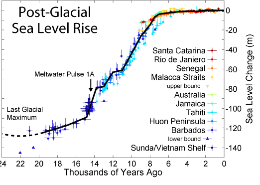
Looking at the history of sea levels, as shown below, we can see clearly that the average sea level has remained almost constant for the past five thousand or six thousand years—especially during the time of Christ and the Book of Mormon time periods. It is even possible that the sea level was lower, by as much as about twenty feet, during the past two thousand years. In that respect, the following quotations are given in the blog supported by Climate Etc.:[2]
-
Global sea level rose by about 120 m during the several millennia that followed the end of the last ice age (approximately 21,000 years ago), and stabilized between 3,000 and 2,000 years ago. Sea level indicators suggest that global sea level did not change significantly from then until the late 19th century.
-
Overall . . . the evidence from the (Roman) fish tanks etc. suggests that there has been no real change in the average height of sea level over the last 2,000 years prior to the mid to late 1800s.
-
Charles Thomas’ model for sea level change in Sicily suggests that at around 1000 BC Mean Sea Level (MSL) was 7.25m lower than today.
The following chart[3] demonstrates the average sea level change for the past twenty-five thousand years and, as far as can be determined, shows that inconsequential changes occurred during the Book of Mormon time period:
It is important to confirm these facts, as applied to the Book of Mormon, with “boots on the ground,” as it were. The average level of Lake Nicaragua, of tectonic origins, is and has been for many centuries about 107 feet above sea level. Further, new evidence has been found of an ancient Preclassic complex society, located on the Caribbean coast in the area of the proposed inundation of Nicaragua, that was living and thriving from about 1500 BC to about AD 400, thus precluding any possibility that any part of Nicaragua was covered with seawater during the times of the Book of Mormon. [4]
More boots-on-the-ground research proves that the Yucatan Peninsula was also not inundated during the Preclassic Period. The following map shows that no part of the middle of the Yucatan Peninsula was covered with seawater during any Book of Mormon time period. Calakmul, La Muneca, and Oxpemul all were thriving “cities” from about 900 BC to after AD 400 and were located within the area proposed by Ainsworth to have been inundated with seawater. They were at an average elevation of over four hundred feet, as shown on the following map of the elevations of the Preclassic ruins in the middle of the Yucatan Peninsula.
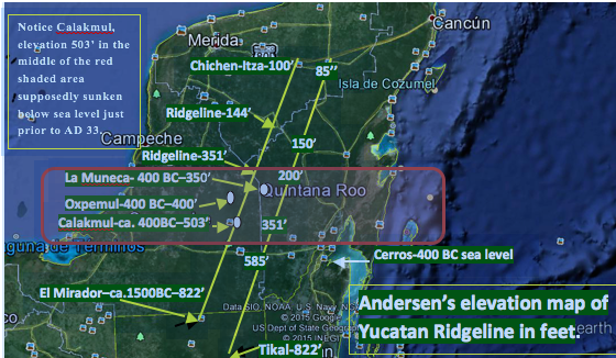
Map showing elevations of various sites in the Yucatan Peninsula
These data further mean that there were no general submersions on either side of the Isthmus of Tehuantepec during Book of Mormon time periods.
Thus, the theory that part of the Yucatan Peninsula was submerged below sea level prior to the time of Christ is totally bogus as it applies to Book of Mormon time periods and to any proposed Book of Mormon geography.
2. Mormon Knew That They Were Not on an “Isle of the Sea.”
The Book of Mormon does not give any information directly about any sea or water boundary south of the narrow strip of wilderness. The only indication is given by the inference that because the land of Nephi, south of the narrow strip of wilderness, was included in the land that was nearly surrounded by water, then there must have been some kind of water barrier to the south. This water barrier need not have gone from the west sea to the east sea because of Mormon’s basic requirement that the land southward was not “completely surrounded by water.”
Mormon’s use of the word “water” instead of “sea” is indicative that he was not thinking of, or “hopefully believing,” that they were on an “isle of the sea.” The definition of “sea” in the 1828 Webster’s dictionary helps readers understand that a sea was viewed as a branch of the ocean and on the same level—and of course not fresh water:
Sea, noun: A large body of water, nearly inclosed by land, as the Baltic or the Mediterranean; as the sea of Azof. Seas are properly branches of the ocean, and upon the same level. Large bodies of water inland, and situated above the level of the ocean, are lakes. The appellation of sea, given to the Caspian lake, is an exception, and not very correct. So the lake of Galilee is called a sea, from the Greek.[5]
Therefore, a sea, a river, and/or a lake or any combination of them could have been a part of the waters that nearly surrounded the land of Nephi and the land of Zarahemla.
Mormon knew that the Nephites were not on an isle of the sea because, by definition, an isle needs to be completely surrounded by a designated, lake, river, or ocean/sea:
Isle, noun: A tract of land surrounded by water, or a detached portion of land embosomed in the ocean, in a lake or river.[6]
Mormon clearly understood that the land of Nephi and the land of Zarahemla were not completely surrounded by water, let alone by a sea. Nephi, son of Lehi, is the only writer of the Book of Mormon who mentions an “isle.” Surely Mormon and Moroni had a much better understanding of the lay of the land and its geography than did Nephi. Because Mormon and Moroni understood that they were not on an isle of the sea, then this term should have no bearing on our understanding the geography of the Book of Mormon.
3. Another Enigma Is the Term “the East” Where No Referent Is Readily Identifiable.
And the Nephites and the armies of Moronihah were driven even into the land of Bountiful. And there [within land Bountiful] they did fortify against the Lamanites, from the west sea, even unto the east; it being a day’s journey for a Nephite, on the line which they had fortified and stationed their armies to defend their north country. (Helaman 4:6–7; emphasis added)
This scripture is clear, except for the location of “the east.” Moronihah stationed his armies on that defensive “line” that started on, and was more or less perpendicular to, the west sea. And the Nephites were stationed from the west sea “to the east,” a distance of one day’s journey for a Nephite—approximately fifteen miles—defending the entryway into “their north county.” The referent for “east” in this scripture is something, not a sea, located about fifteen miles easterly from the west sea. This “line” was located within the west-sea Bountiful because verse 6 says the Nephites were driven “even into the land of Bountiful,” and there they were “stationed on the line.” What is not clear is where, within the west-sea land Bountiful, this line was located and what defines the eastern terminus of the fifteen-mile “line.”
Speaking of the land Bountiful on the west sea, Mormon says, referring to post 72 BC:
And it came to pass that the Nephites had inhabited the land Bountiful, even from the east unto the west sea, and thus the Nephites in their wisdom, with their guards and their armies, had hemmed in the Lamanites on the south [of the narrow strip of wilderness], that thereby they [Lamanites] should have no more possession on the north [of the narrow strip of wilderness], that they might not overrun the land northward.[7] (Alma 22:33; emphasis added)
Again, the west sea is specifically identified as the starting point for going eastward, and the west-sea land Bountiful was inhabited at this time, about 73 BC, exclusively by Nephites. How wide was this land Bountiful from the west sea? How far north of the narrow strip of wilderness did this land Bountiful extend? Where did this west-sea land Bountiful end? And does this term “from the east to the west sea” mean the same distance as “from the west sea, even unto the east” in Helaman 4:7?
Maybe the answers can be found in this next scripture.
And now, it was only the distance of a day and a half’s journey for a Nephite, on the line [between] Bountiful and the land Desolation, from the east to the west sea. (Alma 22:32; emphasis added)
There is nothing in the Book of Mormon that prohibits the conclusion that this “line” between Desolation and Bountiful was the same line, of the approximate same distance (fifteen miles), and running in the same direction from the same west sea as the “line” in Helaman 4:7. Therefore, the northwestern boundary of the west-sea land Bountiful must be this same “line” between Desolation and Bountiful.
This conclusion makes it imperative, therefore, that the west-sea land Bountiful paralleled the Nephite west sea northward from the narrow strip of wilderness until it came to the fifteen-mile “line” that ran eastward from the west sea between Desolation and Bountiful. Therefore, the northwest corner of the west-sea land Bountiful—which must be the same corner for the land southward—was located at the beginning of that “line” on the west sea. And the southwest corner of the land Desolation—which must be the same for the greater Jaredite land northward—must have also been located at that very same point at the beginning of that same “line.”
Proposal: These facts must be paramount and inclusive in any proposed geography of the Book of Mormon.
This proposal narrows down the probable location of the “line,” but still it is not clear exactly where it began on the west sea. Perhaps the next scripture will help. Speaking of the location where Teancum stopped Morianton before Morianton could cross the “line” and enter the land Desolation, Mormon says the following:
And it came to pass that they did not head [stop] them until they had come to [but not in] the borders [the beginning] of the land Desolation; and there [near the “line” but before they got into Desolation] they did head them, by [but not in] the narrow pass which led by the [the only sea mentioned is the west sea] sea into the land northward. (Alma 50:34)
Because they were stopped within Bountiful and before they got to the start of the narrow pass that led by the west sea into the land northward, then they must have been stopped near or within that “narrow passage which led [from the line] into the land southward” (Mormon 2:29). These scriptures also show that before Morianton could have continued on into the greater Jaredite land northward, he would have to have crossed the “line,” entered into the “pass” going northward (Alma 50:34), and continued traveling northward following the west sea for some distance within the land Desolation before he would have gone inland from the west sea.
Admittedly, this reasoning does not pinpoint the start of the “line” on the west sea yet; however, it proves that from the “line” between Desolation and Bountiful, Desolation continued along the west sea for some distance. This thinking precludes the possibility that that “line” between Desolation and Bountiful could have been located at the continental divide within the Isthmus of Tehuantepec. And it also precludes any possibility that any part of the west-sea land Bountiful could have been located north of the continental divide or, for that matter, anywhere within the isthmus. There is further information that can pinpoint where that line started on the west sea—near Horcones, Chiapas, Mexico—before travelers went into the southern part of the isthmus, and that information corroborates all of the above.[8]
Again from Alma 50:34, in the year 67 BC where Mormon talks about Teancum stopping Morianton before Moritanton got into the land Desolation, the scripture continues:
And there they did head them by [but not in] the narrow pass which led by the [west] sea into the land northward, yea by the sea on the west and on the east (emphasis added).
The word “yea” here seems to be another key. Referring to the word “yea,” Webster’s 1828 dictionary says, “It sometimes enforces the sense of something preceding; not only so, but more.”[9] In the sentence, the word “there” emphasizes the location where Morianton and his followers were “headed”: “by the sea on the west and on the east.” Therefore, Mormon is emphasizing that the “heading” took place somewhere before they got to the “line” because he references the west sea again and adds that yet-unidentified location to the east of the west sea about fifteen miles inland, probably a specific location in the Sierra Madre Mountains.
Therefore, Morianton was killed before he got to the “line” and between the west sea, the Pacific, and fifteen miles or so inland, a specific spot in the Sierra Madre Mountains. It all happened near the passage that led into the land southward just before that passage crossed the line and entered the narrow pass that led by the west sea into the land northward. In other words, Morianton was killed just before he got into the southern part of the Isthmus of Tehuantepec. Therefore, the “line” could not have been located within the isthmus, and neither could the small neck of land have been located within the isthmus because the “line” must be located within the “small neck of land” and because that neck of land must be “small.”[10]
4. “Nearly Surrounded by Water” and the “Small Neck of Land.”
What does all this have to do with the initial question of being “nearly surrounded by water?” Just this. Once the basic question is answered as to where that all-important “line” was located that started on the west sea and ran in an easterly direction about fifteen miles or so, then that area must be where the “small neck of land” was located “between” the land northward and the land southward. This must be so because (1) the land Desolation was included as a part of the land northward, (2) the land Bountiful was included as a part of the land southward, and (3) the “line” divided them. The passes did not divide them; Desolation did not divide them; and Bountiful did not divide them. The all-important “line” divided them. That “line” is located where the small neck of land will be found.
And thus the land of Nephi and the land of Zarahemla were nearly surrounded by water, there being a small neck of land between the land northward and the land southward. (Alma 22:32; emphasis added)
The definition of between is helpful here: “In the intermediate space, without regard to distance; as, New York is between Boston and Philadelphia; the Delaware river runs between Pennsylvania and New Jersey.”[11]
An analogy that seems to help understand the nature of the “small neck of land” is the human neck. It does not divide the head from the body but connects it. The neck is not the head or the body, but the neck is located “between” them—the head to the “northward” and the body to the “southward.”
According to this scripture and this definition, if the Isthmus was the “small neck of land between” the land northward and the land southward, then the Gulf of México should be the land northward and the Pacific should be the land southward because it is the Isthmus of Tehuantepec that lies “between” and connects the two oceans, northward/southward.
If one skewed the Isthmus around and made the “small neck of land” between the land on the west—the land northward?—and the land on the east—the land southward?—then the isthmus would not be part of either. Therefore, the heartland of the Olmec—located in the isthmus—would not be part of the land northward or southward. Therefore, this is another reason why the isthmus cannot be the “small neck of land.”
Because the “line” was located, not within the Isthmus of Tehuantepec but to the southeast of it starting on the west sea, then the “small neck of land” was a narrow neck of land paralleling the Pacific Ocean, exactly as F. Richard Hauck proposed in 1988.[12] And that “small neck of land” between the lands northward/southward contained the “two passes” and the “passage” and the “narrow neck” within it, which passes/passage/narrow neck led by the west sea into the lands northward/southward.
Therefore, the Isthmus of Tehuantepec could not have been the “line” or the “small neck of land” or the “narrow neck of land” but must have been the very heartland of the Jaredite land northward itself. This is corroborated by the fact that the Isthmus of Tehuantepec is located exactly northward from the Pacific continental shelf—for example, from Izapa, just like the Book of Mormon states.
5. But What about Being Nearly Surrounded by Water?
As I stated in the beginning of this article, I do not know. However, it seems more likely that because the scripture does not say nearly surrounded by a sea, but by water, then probably a combination of seas, lakes, and rivers is implied. Certainly on the south of the narrow strip of wilderness is the huge Motagua River and river basin that extends from the Gulf of Honduras to Lake Atitlan, and then the river Nahuala extends to the Pacific. This would be a possibility. On the north, maybe the river Coatzacoalcos, the Gulf of Mexico, the Usumacinta River, and the Passion and Sarstoon rivers played a role in Mormon’s statement that the land of Zarahemla and the land of Nephi, including the narrow strip of mountainous wilderness, were nearly surrounded by water. Only Mormon knows.
Certainly, there is no need to do a subterfuge and artificially inundate the middle part of the Yucatan Peninsula to create a shorter route for water to surround the land of Zarahemla and the land of Nephi. All of these theories that an isthmus must be inferred as the “small neck of land” arise from the mistaken notion that the one and only statement, “nearly surrounded by water,” compels it; and that thinking is fallacious. That an isthmus might be involved in the understanding of water nearly surrounding the land of Zarahemla and the land of Nephi is surely possible, but it is not mandatory. It is more likely that the huge Coatzacoalcos River was deemed the waterway that was close to the small neck of land on the Pacific corridor than that the entire huge isthmus was the small neck of land.
An additional key in locating where the small neck of land was situated is in understanding where the all-important “line” was located because that “line” must have been located within the “small neck of land.”
Who knew better than Mormon that that all-important “line” was located, not within the isthmus but within the narrow neck of land/small neck of land that paralleled the west sea, the Pacific? In understanding just how important that “line” was, we must consider how many events Mormon and Moroni described as having occurred in the location near this west-sea “line” that ran from “the west sea to the east.” All of the events and locations, described in endnote 13, were not occurring within the isthmus or within the area of the Olmec heartland or within the United States. They were all occurring near the west sea and before travelers entered into the principal area of the Isthmus of Tehuantepec. They were all happening near the “line”[13] that had to have been located right in the middle of the “small neck of land,” which was located on the Pacific coastal shelf.
Notes
[1]. Jerry L. Ainsworth, The Lives and Travels of Mormon and Moroni (n.p.: Peacemakers Publishing, 2000), 96.
[2]. Climate Etc. is a blog that provides a forum for climate researchers, academics and technical experts from other fields, citizen scientists, and the interested public to engage in a discussion on topics related to climate science and the science-policy interface. The three quotations from Climate Etc. are given in Tony Brown, “Historic Variations in Sea Levels, Part 1: From the Holocene to Romans,” posted on July 12, 2011, http://judithcurry.com/2011/07/12/historic-variations-in-sea-levels-part... (accessed September 8, 2015); emphasis added.
[3]. Ralph W. Tiner, “Changing Sea Levels during the Past 25,000 years,” http://www.fws.gov/slamm/Changes%20in%20Sea%20Level_expanded%20version_t... (accessed September 8, 2015), image created by Robert A. Rohde; also shown in previous citation, Brown, “Historic Variations in Sea Levels.”
[4]. “Lake Nicaragua . . . is a freshwater lake in Nicaragua. Of tectonic origin and with an area of 8,264 km², it is the largest lake in Central America, the nineteenth largest lake in the world. Area: 3,191 mi² (8,264 km²); Surface elevation: 107’ (33 m); Catchment area: 9,206 mi² (23,844 km²); Length: 99.42 miles (160 km); Width: 44.74 miles (72 km).” “Lake Nicaragua,” Wikipedia, https://en.wikipedia.org/wiki/Lake_Nicaragua (accessed September 7, 2015); (emphasis added).
The discovery, near the modern hamlet of Kukra Hill on the Caribbean coast about 200 miles east of Managua, suggests that complex societies were developing in Mesoamerica earlier than researchers had believed, Gassiot said. Experts hope that study of the site—and particularly its violent demise around AD 400—will yield new insights into the evolution of the better-known kingdoms to the north of the area, including the Maya, and the more democratic societies to the south.
The discovery may also help explain why the later Classic Maya civilization rarely used gold, even though it was widely available farther south.
Gassiot does not know who built the city or what eventually became of its inhabitants. The first signs of habitation in the area date to about 1500 BC, and it appears that major construction began about 750 BC.
Archaeologist John W. Hoopes of the University of Kansas speculates that Cascal’s inhabitants were probably ancestors of the Rama Indians, who still live in the area. They probably spoke a language called Chibchan, which was then common throughout the region and is still spoken by a few individuals today. (Thomas H. Maugh II, “The World: Ancient Civilization Found in Nicaragua,” New York Times, June 1, 2003.)
[5]. Noah Webster, An American Dictionary of the English Language (New York: S. Converse, 1828), s.v. “sea.”
[6]. Webster, An American Dictionary of the English Language, s.v. “isle.”
[7]. See my article, “‘The Land North’ Always Means North of The Narrow Strip of Wilderness,” http://www.bmaf.org/articles/land_north_narrow_strip__andersen. “The land north” never refers to north of the narrow neck of land.
[8]. See my article, “Joshua Near the Pacific and Near Izapa, the Final Key in Deciphering the Geography of the Book of Mormon,” http://www. bmaf.org/joshua_pacific_izapa_final_ key_andersen.
[9]. Webster, An American Dictionary of the English Language, s.v. “yea.”
[10]. See my article, “Isthmus of Tehuantepec; Not the Small Neck of Land,” http://www.bmaf.org;isthmus_not_neck_land—andersen.
[11]. Webster, An American Dictionary of the English Language, s.v. “between.”
[12]. See F. Richard Hauck, Deciphering the Geography of the Book of Mormon (Salt Lake City: Deseret Book, 1988), 38 ff.
[13]. The “line” between Desolation and Bountiful is central and controlling in helping readers understand the geography of the Book of Mormon—and especially the location of the “small neck of land.” Readers should onsider all the following events that geographically relate to that “line”:
It began on the west sea and ran eastward a distance of about a day and a half—about fifteen miles or so (Alma 22:31–33, Helaman 4:6–7).
It never bordered any other sea.
It was located northward from Joshua, which was also located near the west sea (Mormon 2:6, 20).
It divided Desolation from Bountiful, both of which also began on the west sea (Alma 22:31–33).
It did not lead into Desolation or Bountiful because the “line” went from the west sea eastward (to the Sierra Madre Mountains). Desolation was located northward from that line, and Bountiful was located southward from that line (Helaman:4:6–7).
Desolation was part of the Jaredite land northward beginning at the “line” (Alma 22:32).
Bountiful was a part of the Nephite land southward, and Bountiful began at the same “line” (Alma 22:32).
The “line” was not the same as the “narrow neck of land” the “small neck of land,” the pass, the passage, or the narrow neck as discussed above because the line led only from the west sea fifteen miles or so to an undisclosed identifiable geographical feature.
It was not the same as the two passes, the passage, or the narrow neck, all of which did not divide anything but each of which led into the lands northward/southward:
“the narrow pass which led by the [west] sea into the land northward” (Alma 50:34).“the narrow pass which led into the land southward” (Mormon 3:5).“the narrow passage which led into the land southward” (Mormon 2:29).“the narrow neck which led into [did not divide] the land northward” (Alma 63:5).
-
It was the entrance or gate into the land southward that began at the “line.” “And they did preserve the land southward [from the “line”] for a wilderness, to get game. And the whole face of the land northward [from the “line”] was covered with inhabitants.” Lib built his city by the entrance into the land southward to preserve the land Bountiful (Alma 22:31) “to hunt food for the people of the land” (see Ether 10:19–22). The dividing “line”—as opposed to a pass or passage leading into something—between the land northward/southward was always the same “line” that began on the west sea and ran eastward.
-
It was near where Morianton was “headed” and killed by Teancum ca. 67 BC by “the borders of the land Desolation . . . by the sea on the west” (Alma 50:33–36).
-
It was where Moronihah, son of Captain Moroni, took refuge with his armies for two years ca. 35 BC while the Lamanites controlled all of the land southward, including Zarahemla and all the east-sea locations (Helaman 4:5–10).
-
It was a defensive “line” or a strategic feature that Moronihah “did fortify against the Lamanites from the west sea even unto the east: it being a day’s journey for a Nephite, on the line which they had fortified and stationed their armies to defend their north countries” (Helaman 4:7). [This “line” clearly ran almost perpendicular to the west sea, and surely Moronihah did not station his armies parallel to the west sea.]
-
It was near where Lachoneus and his people (together with the Lamanite and Nephite armies (3 Nephi 3:14) took refuge for eight years (3 Nephi 6:1) while the Gadianton robbers controlled all the land southward ca. AD 17–26 (3 Nephi 3:22–26, 4:1–5), “yea, to the line which was between the land Bountiful and the land Desolation.”
-
It was near where Hagoth built and sailed his ships in the years ca. 55–54 BC (Alma 63:4–10) “on [within] the borders of the land Bountiful by [but not in] the land Desolation, and launched it forth into the west sea.”
-
It was the treaty “line” of AD 350, which treaty gave the Lamanites/robbers all the land southward, including the pass and/or passage that led from the treaty “line” into the land southward.
-
And, of course, it was the same “line” in which the treaty gave the Nephites all the land northward from the “line” where “the narrow pass which led by the [west] sea into the land northward” began (Mormon 2:28–29).
-
It was adjacent to, and to the south of, the place where the “sea [only one sea] divides the land” (Ether 10:19–21); therefore, the sea that divided the land was the west sea. “They did preserve the land southward [from the “line”] for a wilderness to get game.”
-
It was also near the place where the Nephites beat the Lamanites in AD 362 and dumped the dead bodies of the Lamanites into the west sea.
-
It was the defensive area near, and to the south of, where the city Desolation was located, where the Lamanites, between AD 360 to AD 375, took fifteen years and five major assaults to permanently force Mormon and the Nephites out of Desolation northward to Jashon/Jordan (the Chivela Pass area) in the year AD 375.
-
It was also near the city Desolation and the city Teancum (Mormon 3:5, 4:3).
-
It was also near the place where the “sea divides the land” (Mormon 10:20–21) because it was located near the entryway into the land southward, which entryway into the land southward was always at the “line.”
-
It was the defensive area near, and to the south of, where the city Desolation was located, where the Lamanites, between AD 360 to AD 375, took fifteen years and five major assaults to permanently force Mormon and the Nephites out of Desolation northward to Jashon/Jordan (the Chivela Pass area) in the year AD 375.
-
The length of the “line,” according to Alma 22:32, “from the east to the west sea,” was also the width of the small or narrow neck of land—about fifteen miles or so. This is about the same distance as the width of the west-sea land Bountiful, which was “inhabited,” according to Alma 22:33, “even from the east unto the west sea.” Notice that Mormon does not say that the land Bountiful was inhabited from the east sea to the west sea—a distance of 250 air miles. And notice also that this inhabitation was exclusively by the Nephites because after 72 BC, to which this event is referring, “all” of the Lamanites had been chased out of the north to the south of the narrow strip of wilderness (Alma 22:34).