


Where is the New World somewhere of the Book of Mormon?"
Where is the New World somewhere of the Book of Mormon?"
by Ted Dee Stoddard
Response to a question about which geographic proposal is right, the "Heartland" in eastern U.S. or the "Two Cumorah" in Mesoamerica.
I have been more than casually acquainted with the Book of Mormon most of my life, I found myself very interested in its geography after visits to the territory involved in the Heartland Model as well as visits to the territory involved in the Mesoamerica Model. Facetiously, I say to myself, as I think about proponents of both models, "We can't all be right; in fact, we might all be wrong." From there, I talk to myself further by bringing to my mind what I think is, indeed, a truism: "The Book of Mormon is a real account about real people who lived somewherein the New World." I'm convinced that I significantly augment my testimony and knowledge of the BofM by exploring all possibilities for that "somewhere."
Bottom line: I'm a sample of one with no credentials when it comes to credibility in talking about BofM geography. However, my academic background as a retired university professor of business writing gave me unique skills in researching library sources and in synthesizing what I've found in attempts to answer the following question: "Where is the New World somewhere of the Book of Mormon?" I have edited some of the most important books and articles on the subject and have written several articles which can be found on the BMAF (Book of Mormon Archaeological Forum) website at www.bmaf.org.
"Off the top of my head," here are a few of the significant things I've discovered as a result of my library searching and "on-the-ground examinations" of the territories of both the Mesoamerica Model and the Heartland Model:
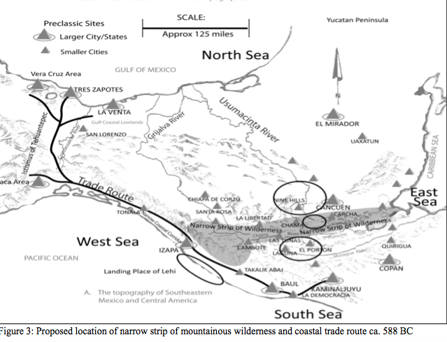
- The Book of Mormon requires a narrow strip of mountainous wilderness that extends from a sea on the east to a sea on the west. For a good part of the thousand-year history of the Nephites, they lived north of that narrow strip of wilderness. The Lamanites lived south of that narrow strip of wilderness. And here's the resulting "kicker:" The only place in the entire New World where that geographic feature is found is the mountainous territory of the Cuchumatanes mountains that extend from the Caribbean Sea on the east to the Pacific Ocean on the west. That territory matches perfectly the BofM description of the narrow strip of wilderness. The proponents of the Heartland Model simply cannot identify a legitimate narrow strip of wilderness because one does not exist in North America as a mountainous strip of wilderness that extends from a sea on the east to a sea on the west.
- According to the BofM, at one point, the Jaredites were the most advanced civilization on the earth. They lived largely in the Jaredite "land northward." The scope of their civilization and the "northward" orientation of their civilization suggest the reality and the requirement that archaeological evidence still exists today for the Jaredite civilization. Indeed, that evidence is territorial everywhere if it is associated with the Olmecs of Mesoamerica. In other words, the archaeological evidence is now almost overwhelming that the Jaredites and the Olmecs were the same people. From radiocarbon-dating techniques, we now know that the demise of the Olmecs as a civilization and people occurred within a hundred years of the demise of the Jaredites. That's simply overpowering information. And no one knew about such correlations via tangible archaeological procedures until midway through the twentieth century! Thus, for over a hundred years, the BofM spoke of two major New World civilizations, but until the 1940s, archaeologists adamantly declared that only one, the Maya, was the "mother race" of the New World. However, that viewpoint changed in the 1940s as archaeologists then realized that the evidence supported the Olmecs as the "mother race" of the New World. The Olmecs and the Jaredites are one and the same civilization. The evidence in Mesoamerica is overwhelming. In response to an absolute requirement that the archaeological leftovers of the Jaredite civilization must be identifiable, the Heartland proponents suggest the territory of Canada north of the Great Lakes. What a travesty! That territory has no archaeological evidence of any civilization that dates to the time of the Jaredites, plus winters can and do drop to minus 50 degrees. Get on the Internet and read about the Olmecs in Mesoamerica. They are the only civilization in the New World that can be equated with the Jaredites from a time perspective and an archaeological ruins perspective.
- In readings from the Book of Mormon, analysts over the years have deduced that the shape of the New World territory of the Book of Mormon is that of an hourglass--a land northward and a land southward joined by a narrow neck. Dr. John Sorenson maintains that the hourglass shape is a critical requirement for the New World territory in which all New World events of the BofM occurred. Any hourglass shape for New World BofM territory in the Heartland Model is simply impossible. However, Mesoamerica fits the hourglass requirement perfectly--as long as BofM geography analysts tip the hourglass over on its side rather than try to stand it up straight as Dr. Sorenson mistakenly has done. Read the BofM with the objective of discerning for yourself that New World BofM geography requires the BofM overall territory to be shaped like an hourglass in a horizontal position. And then think of Mesoamerica as an hourglass in a horizontal position as shown in the map below.
- Finally, examine your thoughts as you think about the territory from the Great Lakes on the north to the Gulf of Mexico on the south as a configured hourglass that matches the descriptive language of the BofM about a land northward and a land southward connected with a narrow neck of land.
- Contrary to Heartlander statements, the BofM's river Sidon must flow north. Therefore, the Mississippi River simply cannot be the BofM's river Sidon. In Mesoamerica, two rivers, the Usumacinta and the Grijalva, conceivably could be the river Sidon because both originate in the narrow strip of wilderness of the Mesoamerica Model within a few miles of each other and then flow north to the Gulf of Mexico. Read the BofM to determine for yourself which direction the river Sidon flows. You'll discover that the Sidon flowed north. You'll then realize that the Mississippi is not the Sidon. At that point, secretly ask yourself whether such adjectives as the following are appropriate in describing the erroneous thinking that the Sidon flowed south: "ludicrous!" "preposterous!" "incredible!" "impossible!" "deceptive!" or "nonsensical!"
- As far as I know, the latest Heartlander attempt to identify an essential, key component of the New World geography of the BofM is to identify the site across the river from Nauvoo as the BofM's city of Zarahemla. Joseph Smith intended to build a city on this site and call that city by what is probably the most prominent city in the BofM--the city of Zarahemla. I can't describe adequately how ludicrous and invalid this step by the Heartlander leadership is. Simply put, the site across the river from Nauvoo has virtually no archaeological evidence to support its identification as the very, very prominent BofM city of Zarahemla. One or more of the following thoughts probably reflect the true nature of the Zarahemla debacle: "This is an act of desperation"; "This is one more behavior by the Heartland leaders that reflects deceptiveness at its worst"; "This is like the ex nihilo thinking that the world was created out of nothing--the Heartlanders' city of Zarahemla was created out of nothing"; or "We have to have a city of Zarahemla somewhere; this has to be it because the BofM's city of Zarahemla obviously was on the west bank of the river Sidon."
Finally, I believe the Book of Mormon is historical rather than ahistorical. The outcomes of a thorough geographical assessment support the historicity of the Book of Mormon if its New World geography includes legitimate candidates for the narrow strip of wilderness, archaeological territory for the Jaredite civilization, an hourglass shape that then justifies the geographic terms of "land northward" and "land southward," a river Sidon that flows north, and a legitimate, viable, valid candidate for the city of Zarahemla.