


Eight Major Features of Book of Mormon Geography
The contents of all BMAF publications are the sole responsibility of the individual authors and therefore do not necessarily represent the views of BMAF or The Church of Jesus Christ of Latter-day Saints.
Eight Major Features of Book of Mormon Geography
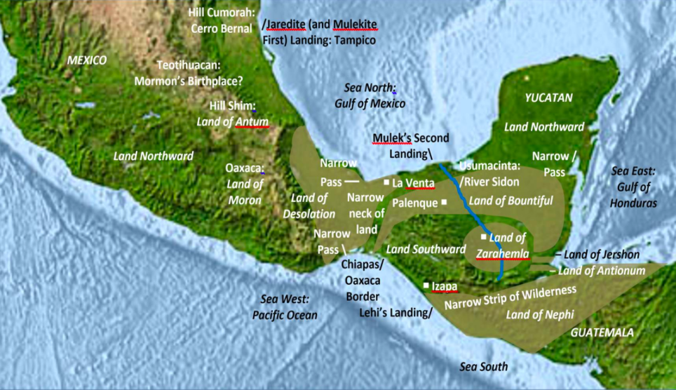
1. Narrow neck of land—and thus the “land northward” and “land southward” associated with this neck.
2. East and west seas—and thus the general areas of many Nephite cities and military campaigns.
3. Narrow strip of wilderness—and thus the lands of Zarahemla to the north and Nephi to the south.
4. Narrow pass—one or more transportation corridors between the lands northward and southward.
5. River Sidon—and the Nephite capital of Zarahemla on its western bank in the “heart of the land.”
6. Land of Bountiful—and thus the “many great cities” and land where Christ appeared.
7. Land of Desolation—and thus a Jaredite homeland and place of the Mulekites’ first landing.
8. Land of Cumorah—the final battle site of the Nephites and Jaredites—the hill known to the Nephites as Cumorah and to the Jaredites as Ramah.
1. Where Is the “Narrow (or Small) Neck of Land”?
The land of Nephi and the land of Zarahemla were nearly surrounded by water, there being a small neck of land between the land northward and the land southward. (Alma 22:32; 90–77 BC; emphasis added)
And it came to pass that Hagoth, he being an exceedingly curious man, therefore he went forth and built him an exceedingly large ship, on the borders of the land Bountiful, by the land Desolation, and launched it forth into the west sea, by the narrow neck which led into the land northward. (Alma 63:5; 56–53 BC; emphasis added)
And they built a great city by the narrow neck of land, by the place where the sea divides the land. (Ether 10:20; 2500–300 BC; emphasis added) [Ether 2:13 explains that “the Lord did bring Jared and his brethren forth even to that great sea which divideth the lands.” Perhaps the words “where the sea divides the land” in Ether 10:20 simply means “the seashore,” as it does in Ether 2:13. If so, the Jaredite seashore city may have been built somewhere on the Gulf of Mexico. See section 7, “Where Was the Land of Desolation?”]
• A land Desolation, perhaps stretching from the Mulekites’ first landing place in the north isthmus (Alma 22:30) to Hagoth’s shipyard (Alma 63:5).
• A land and hill of Cumorah (“Ramah” to the Jaredites—Ether 15:11).
• A land Moron (“where the king dwelt”—Ether 7:6, perhaps encompassing Monte Alban in the state of Oaxaca).
• A land Antum (where sat the hill Shim, a temporary depository of Nephite records—Mormon 1:3).
• Other areas, perhaps including Mormon’s birthplace (Mormon 1:6—perhaps in Teotihuacan, ca. AD 310).
• The land of first inheritance, where Lehi’s party landed in the New World, perhaps on the Pacific coast near the Mexico-Guatemala border, in roughly 587 BC (Alma 22:28).
• The land of Nephi—where Nephi’s people settled after moving inland from the land of first inheritance (perhaps to the Guatemalan highlands—Mosiah 28:5–6).
• A narrow strip of wilderness (see section 3, “Where Is the Narrow Strip of Wilderness?”).
• The land and city of Zarahemla—the city established by descendants of Mulek, to which Mosiah1 (as distinguished from his grandson Mosiah2) and his Nephite followers migrated from the land of Nephi in roughly 200 BC (see section 5, “Where Were the River Sidon and the City of Zarahemla?”).
• A land between Zarahemla and Bountiful (1 Nephi 3:23)—perhaps Hermounts (Alma 2:37).
• The land of Bountiful—just north of the land of Zarahemla, but south of the narrow neck of land, which presumably contained the “more capital parts of the land” (Helaman 1:27) and which held the “great cities” (Helaman 7:22) and the place where Christ appeared (3 Nephi 11:1).
And now, my beloved brethren [said Jacob], seeing that our merciful God has given us so great knowledge concerning these things, let us remember him, and lay aside our sins, and not hang down our heads, for we are not cast off; nevertheless, we have been driven out of the land of our inheritance [the land of Jerusalem]; but we have been led to a better land, for the Lord has made the sea our path, and we are upon an isle of the sea.
But great are the promises of the Lord unto them who are upon the isles of the sea; wherefore as it [the brass plates of Laban?] says isles, there must needs be more than this, and they are inhabited also by our brethren. (2 Nephi 10:20–21; 559–545 BC; emphasis added)
And now, it was only the distance of a day and a half’s journey for a Nephite, on the line Bountiful and the land Desolation, from the east to the west sea; and thus the land of Nephi and the land of Zarahemla were nearly surrounded by water, there being a small neck of land between the land northward and the land southward. (Alma 22:32; 90–77 BC; emphasis added)
And there they did fortify against the Lamanites, from the west sea, even unto the east; it being a day’s journey for a Nephite, on the line which they had fortified and stationed their armies to defend their north country. (Helaman 4:7; 38–30 BC; emphasis added)
Neither of these verses appears to describe the width of the narrow neck of land. The Alma verse seems to refer to a border line between Bountiful and the land Desolation, which stretched from the west sea to some point in the east. The verse in Helaman refers to the length of a fortified line, beginning at the west sea and continuing to some eastern point. Neither verse says this line continues to the “east sea.” Conceivably, both lines refer to the same place. A borderline seems to be described in the following verse:
And the land which was appointed was the land of Zarahemla, and the land which was between the land Zarahemla and the land Bountiful, yea, to the line which was between the land Bountiful and the land Desolation. (3 Nephi 3:23; AD 16–17; emphasis added)
And they were lost in the wilderness for the space of many days, yet they were diligent, and found not the land of Zarahemla but returned to this land, having traveled in a land among many waters, having discovered a land which was covered with bones of men, and of beasts, and was also covered with ruins of buildings of every kind, having discovered a land which had been peopled with a people who were as numerous as the hosts of Israel. (Mosiah 8:8; 121 BC; emphasis added)

And it came to pass that they did multiply and spread, and did go forth from the land southward to the land northward, and did spread insomuch that they began to cover the face of the whole earth, from the sea south to the sea north, from the sea west to the sea east. (Helaman 3:8; 49–39 BC; emphasis added)
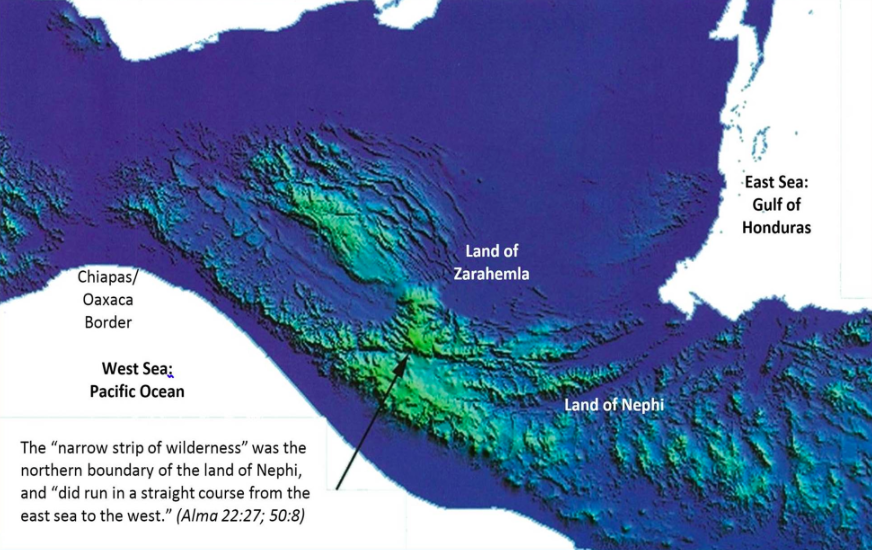
And the land of Nephi did run in a straight course from the east sea [presumably the Gulf of Honduras] to the west [that is, from the east sea to the west, south of the narrow strip of wilderness].
And it came to pass that when [Captain] Moroni had driven all the Lamanites out of the east wilderness, which was north of the lands of their [the Lamanites’] own possessions [the land of Nephi], he caused that the inhabitants who were in the land of Zarahemla and in the land round about should go forth into the east wilderness, even to the borders by the seashore [presumably the coasts of Belize and Honduras, on the Gulf of Honduras], and possess the land. [This verse must mean that the Lamanites were driven from the “borders by the seashore” near the Gulf of Honduras south to the land of Nephi because driving Lamanites from the Gulf of Mexico to the land of Nephi would have been a distance of over four hundred miles.]
And he also placed armies on the south [of Zarahemla, along the narrow strip of wilderness], in the borders of their [the Nephites’] possessions, and caused them [the Nephites] to erect fortifications that they might secure their armies and their people from the hands of their enemies [the Lamanites who lived south of the narrow strip of wilderness in the land of Nephi].
And thus he [Moroni1] cut off all the strongholds of the Lamanites in the east wilderness [by driving the Lamanites south into the land of Nephi and moving Nephites into this vacated area], yea, and also on the west, fortifying the line between the Nephites and the Lamanites between the land of Zarahemla and the land of Nephi [along the narrow strip of wilderness], from the west sea [the Pacific Ocean], running by the head of the river Sidon [running east along the narrow strip of wilderness]—the Nephites possessing all the land northward, yea, even all the land which was northward of the land Bountiful, according to their pleasure [see the discussion of the land of Bountiful in section 6, “Where Was the Land of Bountiful?”].
Thus Moroni, with his armies, which did increase daily because of the assurance of protection which his works did bring forth unto them, did seek to cut off the strength and the power of the Lamanites from off the lands of their [the Nephites’] possessions, that they should have no power upon the lands of their possession.
And it came to pass that the Nephites began the foundation of a city, and they called the name of the city Moroni; and it was by the east sea; and it was on the south by the line of the possessions of the Lamanites [the Gulf of Honduras side of the narrow strip of wilderness—just north of the land of Nephi]. (Alma 50:8–13; 72–67 BC; emphasis added)
And it came to pass that the voice of the [Nephite] people came, saying: Behold, we will give up the land of Jershon, which is on the east by the sea, which joins the land Bountiful, which is on the south of the land Bountiful; and this land Jershon is the land which we will give unto our brethren [the people of Ammon] for an inheritance. (Alma 27:22; 90–77 BC; emphasis added)
Now the Zoramites had gathered themselves together in a land which they called Antionum, which was east of the land of Zarahemla, which lay nearly bordering upon the seashore, which was south of the land of Jershon, which also bordered upon the wilderness south [presumably the narrow strip of wilderness], which wilderness was full of the Lamanites. (Alma 31:3; 74 BC; emphasis added)
And the people of Ammon departed out of the land of Jershon, and came over [presumably west] into the land of Melek, and gave place in the land of Jershon for the armies of the Nephites, that they might contend with the armies of the Lamanites and the armies of the Zoramites. [The Zoramites were based in the land of Antionum near the Gulf of Honduras just north of the narrow strip of wilderness; see Alma 31:3 above. Thus, Jershon was located near the Gulf of Honduras—north of the lands of Nephi and Antionum and south of the land Bountiful.] (Alma 35:13; 74 BC; emphasis added)
Now Moroni, leaving a part of his army in the land of Jershon, lest by any means a part of the Lamanites should come into that land and take possession of the city [north of the narrow strip of wilderness on the east sea], took the remaining part of his army and marched [west] over into the land of Manti [just north of the east-west center of the narrow strip of wilderness near the headwaters of the river Sidon]. (Alma 43:25; 74 BC; emphasis added)
Now, the king [of the Lamanites, the dissident Nephite Ammoron] had departed out of the land of Zarahemla [which he had recently conquered], and had made known unto the queen concerning the death of his brother [Amalikiah, the queen’s husband], and had gathered together a large number of men, and had marched forth against the Nephites on the borders by the west sea [perhaps near Antiparah and an unnamed city by the seashore, where Helaman and the stripling soldiers later fought. The name “seashore city” was bestowed on this location by John E. Clark].7
And thus he [Ammoron] was endeavoring to harass the Nephites, and to draw away a part of their forces to that part of the land [near the west sea], while he had commanded those whom he had left to possess the cities which he had taken, that they should also harass the Nephites on the borders by the east sea [the Gulf of Honduras], and should take possession of their lands as much as it was in their power, according to the power of their armies. (Alma 52:12–13; 66–64 BC; emphasis added)
And thus it did come to pass that the people of Nephi began to prosper again in the land, and began to build up their waste places, and began to multiply and spread, even until they did cover the whole face of the land, both on the northward and on the southward, from the sea west to the sea east. [Apparently, many Nephites lived near the east sea and west sea shortly before Christ’s visit.] (Helaman 11:20; 20–7 BC; emphasis added)
And he [Captain Moroni] also placed armies on the south, in the borders of their possessions [near the narrow strip of wilderness], and caused them to erect fortifications that they might secure their armies and their people from the hands of their enemies.
And thus he cut off all the strongholds of the Lamanites in the east wilderness, yea, and also on the west, fortifying the line between the Nephites and the Lamanites, between the land of Zarahemla and the land of Nephi, from the west sea, running by the head of the river Sidon—the Nephites possessing all the land northward, yea, even all the land which was northward of the land Bountiful, according to their pleasure [perhaps including the Yucatan Peninsula—a possibility that will be discussed later]. (Alma 50:10–11; 72–67 BC; emphasis added)
Now, the king [Ammoron] had departed out of the land of Zarahemla, and had made known unto the queen concerning the death of his brother, and had gathered together a large number of men, and had marched forth against the Nephites on the borders by the west sea.
And thus he was endeavoring to harass the Nephites, and to draw away a part of their forces to that part of the land [by the west sea, south], while he had commanded those whom he had left to possess the cities which he had taken, that they should also harass the Nephites on the borders by the east sea, and should take possession of their lands as much as it was in their power, according to the power of their armies. (Alma 52:12–13; 66–64 BC; emphasis added)
And now it came to pass that the armies of the Lamanites, on the west sea, south, while in the absence of Moroni on account of some intrigue amongst the Nephites, which caused dissensions amongst them, had gained some ground over the Nephites, yea, insomuch that they had obtained possession of a number of their cities in that part of the land. . . .
And now it came to pass that Helaman did march at the head of his two thousand stripling soldiers, to the support of the people in the borders of the land on the south by the west sea. (Alma 53:8, 22; 64 BC; emphasis added)
Now when we saw that the Lamanites began to grow uneasy on this wise, we were desirous to bring a stratagem into effect upon them; therefore Antipus ordered that I [Helaman] should march forth with my little sons to a neighboring city, as if we were carrying provisions to a neighboring city.
And we were to march near the city of Antiparah, as if we were going to the city beyond, in the borders by the seashore [“seashore city” on the sea west]. . . .
And it came to pass that we did march forth, as if with our provisions, to go to that city.
And it came to pass that Antipus did march forth with a part of his army, leaving the remainder to maintain the city. But he did not march forth until I had gone forth with my little army, and came near the city Antiparah.
And now, in the city Antiparah were stationed the strongest army of the Lamanites; yea, the most numerous. .
And it came to pass that when they had been informed by their spies, they came forth with their army and marched against us.
And it came to pass that we did flee before them, northward. And thus we did lead away the most powerful army of the Lamanites. (Alma 56:30–36; 66–62 BC; emphasis added)
And it came to pass that Hagoth, he being an exceedingly curious man, therefore he went forth and built him an exceedingly large ship, on the borders of the land Bountiful, by the land Desolation, and launched it forth into the west sea, by the narrow neck which led into the land northward. [Presumably this and other ships built here would have required lumber from large trees, which may have been more numerous in the land of Bountiful than the land of Desolation.] (Alma 63:5; 56–53 BC; emphasis added)
And it came to pass that in the thirty and seventh year of the reign of the judges, there was a large company of men, even to the amount of five thousand and four hundred men, with their wives and their children, departed out of the land of Zarahemla into the land which was northward. [The land northward of Zarahemla was presumably Mexico north of the isthmus, given the information in the following two verses.]
And it came to pass that Hagoth, he being an exceedingly curious man, therefore he went forth and built him an exceedingly large ship, on the borders of the land Bountiful, by the land Desolation, and launched it forth into the west sea, by the narrow neck which led into the land northward. [Evidently, the lands of Bountiful and Desolation converged at the west sea in or near the narrow neck of land.] . . .
And it came to pass in the thirty and ninth year of the reign of the judges, Shiblon died also, and Corianton had gone forth to the land northward in a ship, to carry forth provisions unto the people who had gone forth into that land. (Alma 63:4–5, 10; 56–53 BC; emphasis added)
And it came to pass in the forty and sixth, yea, there was much contention and many dissensions; in the which there were an exceedingly great many who departed out of the land of Zarahemla, and went forth unto the land northward to inherit the land. . . .
And it came to pass as timber was exceedingly scarce in the land northward, they did send forth much by the way of shipping. . . .
And it came to pass that there were many of the people of Ammon, who were Lamanites by birth, did also go forth into this land. (Helaman 3:3, 10, 12; 49–39 BC; emphasis added)
Now, the more idle part of the Lamanites lived in the wilderness, and dwelt in tents; and they were spread through the wilderness on the west, in the land of Nephi [Guatemala]; yea, and also on the west of the land of Zarahemla, in the borders by the seashore, [along the Pacific coast corridor from the narrow strip of wilderness north to the Isthmus of Tehuantepec—the southeastern border of the land of Desolation] and on the west in the land of Nephi, in the place of their fathers’ first inheritance, and thus bordering along by the seashore. (Alma 22:28; between 90–77 BC; emphasis added)
Behold, I am Amaleki, the son of Abinadom. Behold, I will speak unto you somewhat concerning Mosiah, [Mosiah1] who was made king over the land of Zarahemla; for behold, he being warned of the Lord that he should flee out of the land of Nephi, and as many as would hearken unto the voice of the Lord should also depart [to the north] out of the land with him, into the [south] wilderness—
And it came to pass that he did according as the Lord had commanded him. And they departed out of the land into the wilderness, as many as would hearken unto the voice of the Lord; and they were led by many preachings and prophesyings. And they were admonished continually by the word of God; and they were led by the power of his arm, through the wilderness until they came down [perhaps northward from the Guatemalan highlands, traveling along the Usumacinta River—the river Sidon; see section 7] into the land which is called the land of Zarahemla.
And they discovered a people, who were called the people of Zarahemla. Now, there was great rejoicing among the people of Zarahemla; and also Zarahemla did rejoice exceedingly, because the Lord had sent the people of Mosiah with the plates of brass which contained the record of the Jews.
Behold, it came to pass that Mosiah discovered that the people of Zarahemla came out from Jerusalem at the time that Zedekiah, king of Judah, was carried away captive into Babylon.
And they journeyed in the wilderness, and were brought by the hand of the Lord across the great waters [conceivably hiring a Phoenician ship], into the land where Mosiah discovered them; and they had dwelt there from that time forth.
And at the time that Mosiah discovered them, they had become exceedingly numerous. Nevertheless, they had had many wars and serious contentions, and had fallen by the sword from time to time; and their language had become corrupted; and they had brought no records with them; and they denied the being of their Creator; and Mosiah, nor the people of Mosiah, could understand them.
But it came to pass that Mosiah caused that they should be taught in his language. And it came to pass that after they were taught in the language of Mosiah, Zarahemla gave a genealogy of his fathers, according to his memory; and they are written, but not in these plates.
And it came to pass that the people of Zarahemla, and of Mosiah, did unite together; and Mosiah was appointed to be their king. (Omni 1:12–19; 361–120 BC; emphasis added)
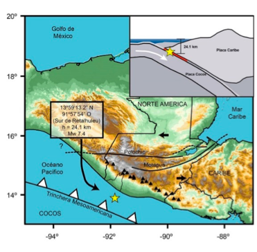
And it came to pass that the [Lamanite] king sent a proclamation throughout all the land [of Nephi], amongst all his people who were in all his land, who were in all the regions round about, which was bordering even to the sea, on the east [the Gulf of Honduras; see “The East Sea—the Gulf of Honduras,” under section 2, “Where Are the Seas Surrounding the Book of Mormon Lands?”] and on the west [perhaps near the Pacific coast of Guatemala; see “The West Sea—the Pacific off Mexico,” under section 2, “Where Are the Seas Surrounding the Book of Mormon Lands?”], and which was divided from the land of Zarahemla by a narrow strip of wilderness [possibly the Motagua fault], which ran from the sea east even to the sea west . . . and thus were the Lamanites and the Nephites divided. (Alma 22:27; 90–77 BC; emphasis added)
And the land of Nephi did run in a straight course from the east sea to the west [from the Gulf of Honduras extending perhaps to the west sea spot where Lehi landed]. (Alma 50:8; 72–67 BC; emphasis added)
Now the land south [of the narrow strip of wilderness] was called Lehi, and the land north was called Mulek [or, more often, the lands of Zarahemla and Bountiful], which was after the son of Zedekiah; for the Lord did bring Mulek into the land north [of the narrow strip of wilderness], and Lehi into the land south [of the narrow strip of wilderness]. (Helaman 6:10; 29–24 BC; emphasis added)
And the Nephites and the armies of Moronihah were driven even into the land of Bountiful. . . . And there they did fortify against the Lamanites, from the west sea, even unto the east; it being a day’s journey for a Nephite, on the line which they had fortified and stationed their armies to defend their north country. (Helaman 4:6–7; 38–30 BC; emphasis added)
And the Lamanites did give unto us the land northward, yea, even to the narrow passage which led into the land southward and we did give unto the Lamanites all the land southward [of the narrow passage, including at least the lands of Nephi, Zarahemla, and Bountiful—presumably including the “capital parts of the land” with many “great cities,” and the lands on the east sea—the Gulf of Honduras as explained in section 2, “Where Are the Seas Surrounding the Book of Mormon Lands?”]. (Mormon 2:29; AD 327–350; emphasis added)
And it came to pass that I [Mormon] did cause my people that they should gather themselves together at the land Desolation, to a city which was in the borders [the city of Desolation; see verse 7], by the narrow pass which led into the land southward [from the land northward where Mormon was raised; see Mormon 1:6].
And there we did place our armies, that we might stop the armies of the Lamanites, that they might not get possession of any of our lands [in the land northward]; therefore we did fortify against them with all our force. [Evidently, a primary focus of the Nephite armies in AD 350 was preventing Lamanites from entering the land northward through the narrow pass.]
And it came to pass that in the three hundred and sixty and first year the Lamanites did come down to the city of Desolation to battle against us [perhaps down from the Sierra Madre mountains in the southeast section of the isthmus]; and it came to pass that in that year we did beat them, insomuch that they did return to their own lands again [presumably back “up” into the Sierra Madres or to the land of Nephi].
And in the three hundred and sixty and second year they did come down again to battle. And we did beat them again, and did slay a great number of them, and their dead were cast into the sea [presumably the west sea near the land of Desolation]. (Mormon 3:5–8; AD 350–362; emphasis added)
And I, Mormon, wrote an epistle unto the king of the Lamanites, and desired of him that he would grant unto us that we might gather together our people unto the land of Cumorah, by a hill which was called Cumorah, and there we could give them battle.
And it came to pass that the king of the Lamanites did grant unto me the thing which I desired.
And it came to pass that we did march forth to the land of Cumorah, and we did pitch our tents round about the hill Cumorah; and it was in a land of many waters, rivers, and fountains; and here we had hope to gain advantage over the Lamanites.
And when three hundred and eighty and four years had passed away, we had gathered in all the remainder of our people unto the land of Cumorah. (Mormon 6:2–5; AD 384–385; emphasis added)
And it came to pass that in the three hundred and twenty and seventh year the Lamanites did come upon us with exceedingly great power, insomuch that they did frighten my armies; therefore they would not fight, and they began to retreat towards the north countries.
And it came to pass that we did come to the city of Angola, and we did take possession of the city, and make preparations to defend ourselves against the Lamanites. And it came to pass that we did fortify the city with our might; but notwithstanding all our fortifications the Lamanites did come upon us and did drive us out of the city.
And they did also drive us forth out of the land of David.
And we marched forth and came to the land of Joshua, which was in the borders west by the seashore.
And it came to pass that we did gather in our people as fast as it were possible, that we might get them together in one body. (Mormon 2:3–7; AD 327–350; emphasis added)
Now behold, the people who were in the land Bountiful, or rather Moroni, feared that they would hearken to the words of Morianton [a dissident Nephite] and unite with his people, and thus he [Morianton] would obtain possession of those parts of the land [Bountiful], which would lay a foundation for serious consequences among the people of Nephi, yea, which consequences would lead to the overthrow of their liberty.
Therefore Moroni sent an army, with their camp, to head the people of Morianton, to stop their flight into the land northward.
And it came to pass that they [the army sent by Captain Moroni] did not head them until they had come to the borders of the land Desolation [presumably an area where people, probably Jaredites, had been killed—see section 7, “Where Is the Land of Desolation?”]; and there they did head them, by the narrow pass which led by the sea into the land northward, yea, by the sea, on the west and on the east. (Alma 50:32–34; 72–67 BC; emphasis added)
And thus he [Amalakiah, a dissident Nephite who became king of the Lamanites] went on, taking possession of many cities, the city of Nephihah, and the city of Lehi, and the city of Morianton, and the city of Omner, and the city of Gid, and the city of Mulek, all of which were on the east borders by the seashore [the Gulf of Honduras]. (Alma 51:26; 67 BC; emphasis added)
And it came to pass that the king [of the Lamanites] sent a proclamation throughout all the land, amongst all his people who were in all his land, who were in all the regions round about, which was bordering even to the sea, on the east and on the west, and which was divided from the land of Zarahemla by a narrow strip of wilderness, which ran from the sea east even to the sea west, and round about on the borders of the seashore, and the borders of the wilderness which was on the north by the land of Zarahemla, through the borders of Manti, by the head of the river Sidon [in the narrow strip of wilderness], running from the east towards the west [it is not the river Sidon that runs “from the east towards the west” but the Lamanite border near the river headwaters]—and thus were the Lamanites and the Nephites divided. (Alma 22:27; 90–77 BC; emphasis added)
And thus he [Captain Moroni] cut off all the strongholds of the Lamanites in the east wilderness [near the Gulf of Honduras close to the land of Nephi], yea, and also on the west, fortifying the line between the Nephites and the Lamanites, between the land of Zarahemla and the land of Nephi, from the west sea, running by the head of the river Sidon—the Nephites possessing all the land northward [of the narrow strip of wilderness], yea, even all the land which was northward of the land Bountiful [the land of Desolation and the north countries], according to their pleasure. (Alma 50:11; 72–57 BC; emphasis added)
And it came to pass that because of so much contention and so much difficulty in the government, that they had not kept sufficient guards in the land of Zarahemla; for they had supposed that the Lamanites durst not come into the heart of their lands to attack that great city Zarahemla. . . .
And, supposing that their greatest strength was in the center of the land, therefore he [the Lamanite general Coriantumr] did march forth, giving them no time to assemble themselves together save it were in small bodies; and in this manner they did fall upon them and cut them down to the earth.
But behold, this march of Coriantumr through the center of the land gave [Nephite general] Moronihah great advantage over them, notwithstanding the greatness of the number of the Nephites who were slain.
For behold, Moronihah had supposed that the Lamanites durst not come into the center of the land, but that they would attack the cities round about in the borders as they had hitherto done; therefore Moronihah had caused that their strong armies should maintain those parts round about by the borders.
But behold, the Lamanites were not frightened according to his [Moronihah’s] desire, but they had come into the center of the land, and had taken the capital city which was the city of Zarahemla, and were marching through the most capital parts of the land [they were headed north to the land of Bountiful, where the “capital parts of the land” were located—those with the greatest agriculture, population and wealth, perhaps including Palenque, Becan, El Mirador, and Tikal], slaying the people with a great slaughter, both men, women, and children, taking possession of many cities and of many strongholds. (Helaman 1:18, 24–27; 52–51 BC; emphasis added)
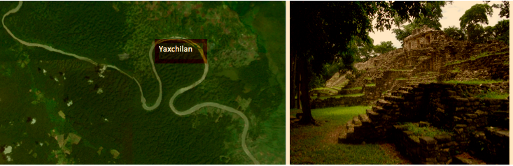
Figure 5. In the Google Earth image on the left, the ruins of Yaxchilan lie on a highland beneath the forest canopy, nearly encircled by the Usumacinta River, which here divides Mexico and Guatemala. On the right is shown the west acropolis of Yaxchilan.
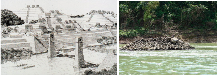
Figure 6. On the left is a computer simulation by archaeoengineer James A. O’Kon in the National Geographic Magazine. On the right is a pile of stones in the Usumacinta thought by him to be one ofthe supporting piers of the bridge.
• One land Bountiful lies near the “sea west” (the Pacific Ocean), near the narrow neck of land (Alma 63:5).
• Another is located on the sea east (the Gulf of Honduras of the Atlantic Ocean) north of Jershon (Alma 27:22).
And also there were many Lamanites on the east by the seashore [at the Gulf of Honduras], whither the Nephites had driven them. And thus the Nephites were nearly surrounded by the Lamanites [perhaps on the west in the Sierra Madre Mountains, the south in the land of Nephi, and the east in the Lamanite possessions along the Gulf of Honduras]; nevertheless the Nephites had taken possession of all the northern parts of the land [north of the land of Nephi] bordering on the wilderness [the narrow strip of wilderness], at the head of the river Sidon, from the east to the west [along the narrow strip of wilderness], round about on the wilderness side, on the north, even until they came to the land which they called Bountiful.
And it [the land Bountiful] bordered upon the land which they called Desolation [north of the Chiapas/Oaxaca border on the west sea], it being so far northward that it came into the land which had been peopled and been destroyed, [see section 7, “Where Was the Land of Desolation?”; Olmec/Jaredite ruins would have been present at Tres Zapotes, San Lorenzo Tenochtitlan, and La Venta—in the states of Veracruz and Tabasco north of the territory of Zarahemla and Bountiful] of whose bones we have spoken, which was discovered by the people of Zarahemla, it being the place of their first landing [thus, the Mulekites landed to the north in the Gulf of Mexico before traveling south to Zarahemla].
And they [the Mulekites] came from there [the place of first landing] up into the south wilderness [going “up” the river Sidon means going upstream, south from the Gulf of Mexico where the Usumacinta or Grijalva reaches the sea, perhaps all the way south to the headwaters of the river Sidon in the narrow strip of wilderness]. Thus the land on the northward [of the narrow neck of land] was called Desolation, and the land on the southward [of the narrow neck] was called Bountiful, it being the wilderness which is filled with all manner of wild animals of every kind, a part of which had come from the land northward for food.
And now, it was only the distance of a day and a half’s journey for a Nephite, on the line Bountiful and the land Desolation, from the east [not the east sea] to the west sea [this “line” is presumably the border between Bountiful and Desolation at the south end of the isthmus]; and thus the land of Nephi and the land of Zarahemla were nearly surrounded by water, there being a small neck of land between the land northward and the land southward.
And it came to pass that the Nephites had inhabited the land Bountiful, even from the east [perhaps as far as the east sea] unto the west sea, and thus the Nephites in their wisdom, with their guards and their armies, had hemmed in the Lamanites on the south [south of the narrow strip of wilderness], that thereby they should have no more possession on the north [of the narrow strip of wilderness] that they might not overrun the land northward. (Alma 22:29–33; 90–77 BC; emphasis added)
And it came to pass that Hagoth, he being an exceedingly curious man, therefore he went forth and built him an exceedingly large ship, on the borders of the land Bountiful, by the land Desolation, and launched it forth into the west sea, by the narrow neck which led into the land northward. (Alma 63:5; 56–53 BC; emphasis added)
And in the fifty and seventh year they [the Lamanites] did come down [from the land of Nephi in the Guatemalan highlands] against the Nephites to battle, and they did commence the work of death; yea, insomuch that in the fifty and eighth year of the reign of the judges they succeeded in obtaining possession of the land of Zarahemla; yea, and also all the lands, even unto the land which was near the land Bountiful [west].
And the Nephites and the armies of Moronihah were driven even into the land of Bountiful;
And there they did fortify against the Lamanites, from the west sea, even unto the east; it being a day’s journey for a Nephite, on the line which they had fortified and stationed their armies to defend their north country. (Helaman 4:5–7; 38–30 BC; emphasis added)
And the land which was appointed was the land of Zarahemla, and the land which was between the land Zarahemla and the land Bountiful [perhaps Hermounts of Alma 2:37], yea, to the line which was between the land Bountiful and the land Desolation [perhaps the line spoken of in Alma 22:32, which could be traversed by a Nephite in a day and a half and which was located on the Chiapas-Oaxaca border by the west sea]. (3 Nephi 3:23; AD 16–17; emphasis added)
And now it came to pass that there were a great multitude gathered together, of the people of Nephi, round about the temple which was in the land Bountiful; and they were marveling and wondering one with another, and were showing one to another the great and marvelous change which had taken place. (3 Nephi 11:1; AD 34; emphasis added.)
And it came to pass that the voice of the [Nephite] people came, saying: Behold, we will give up the land of Jershon, which is on the east by the sea [on the Gulf of Honduras], which joins the land Bountiful, which is on the south of the land Bountiful; and this land Jershon is the land which we will give unto our brethren [the people of Ammon, formerly called the people of Anti-Nephi-Lehi] for an inheritance. (Alma 27:22; 90–77 BC; emphasis added)
Now the Zoramites had gathered themselves together in a land which they called Antionum, which was east of the land of Zarahemla, which lay nearly bordering upon the seashore, which was south of the land of Jershon, which also bordered upon the wilderness south [narrow strip of wilderness], which wilderness was full of the Lamanites. (Alma 31:3; 74 BC; emphasis added)
Thus Moroni, with his armies, which did increase daily because of the assurance of protection which his works did bring forth unto them, did seek to cut off the strength and the power of the Lamanites from off the lands of their [the Nephites’] possessions, that they should have no power upon the lands of their possession.
And it came to pass that the Nephites began the foundation of a city, and they called the name of the city Moroni; and it was by the east sea; and it was on the south by the line of the possessions of the Lamanites [near the Gulf of Honduras]. . . .
Now behold, the people who were in the land Bountiful, or rather Moroni, feared that they [the people of Morianton] would hearken to the words of Morianton and unite with his people, and thus he would obtain possession of those parts of the land, which would lay a foundation for serious consequences among the people of Nephi, yea, which consequences would lead to the overthrow of their liberty. (Alma 50:12–13, 32; 72–67 BC; emphasis added)
And thus he [Amalakiah] went on, taking possession of many cities, the city of Nephihah, and the city of Lehi, and the city of Morianton, and the city of Omner, and the city of Gid, and the city of Mulek, all of which were on the east borders by the seashore [the Gulf of Honduras].
And thus had the Lamanites obtained, by the cunning of Amalickiah, so many cities, by their numberless hosts, all of which were strongly fortified after the manner of the fortifications of Moroni; all of which afforded strongholds for the Lamanites.
And it came to pass that they marched to the borders of the land Bountiful, driving the Nephites before them and slaying many.
But it came to pass that they were met by Teancum, who had slain Morianton and had headed his people in his flight.
And it came to pass that he headed Amalickiah also, as he was marching forth with his numerous army that he might take possession of the land Bountiful, and also the land northward. [Teancum apparently headed Amalikiah as he was going north to Bountiful along the Gulf of Honduras.]
But behold he met with a disappointment by being repulsed by Teancum and his men, for they were great warriors; for every man of Teancum did exceed the Lamanites in their strength and in their skill of war, insomuch that they did gain advantage over the Lamanites.
And it came to pass that they did harass them, insomuch that they did slay them even until it was dark. And it came to pass that Teancum and his men did pitch their tents in the borders of the land Bountiful; and Amalickiah did pitch his tents in the borders on the beach by the seashore, and after this manner were they driven. (Alma 51:26–32; 67 BC; emphasis added)
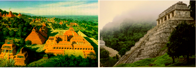
Figure 7. On the left is the National Geographic computer re–creation of Palenque; on the right is the Temple of Inscriptions, where Ainsworth suggests Christ may have appeared to the Nephites.
And now, when the Lamanites saw this [Amalickiah killed by Teancum’s javelin on New Year’s day] they were affrighted; and they abandoned their design in marching into the land northward, and retreated with all their army into the city of Mulek [located on the Gulf of Honduras; see Alma 51:26 above], and sought protection in their fortifications. . . .
And it came to pass that he kept thus preparing for war until Moroni had sent a large number of men to strengthen his army. . . .
And he also sent orders unto him that he should fortify the land Bountiful, and secure the narrow pass [perhaps a corridor north into the Yucatan Peninsula] which led into the land northward, lest the Lamanites should obtain that point and should have power to harass them on every side.
And Moroni also sent unto him, desiring him that he would be faithful in maintaining that quarter of the land [the land near the east sea], and that he would seek every opportunity to scourge the Lamanites in that quarter, as much as was in his power, that perhaps he might take again by stratagem or some other way those cities which had been taken out of their hands; and that he also would fortify and strengthen the cities round about, which had not fallen into the hands of the Lamanites.
And he also said unto him, I [Moroni] would come unto you [Teancum, who was fighting near the Gulf of Honduras], but behold, the Lamanites are upon us in the borders of the land by the west sea; and behold, I go against them, therefore I cannot come unto you. [Apparently, Teancum was by the east sea, whereas Moroni was by the west sea, perhaps near Izapa.]
Now, the king [Ammoron] had departed out of the land of Zarahemla, and had made known unto the queen concerning the death of his brother, and had gathered together a large number of men, and had marched forth against the Nephites on the borders by the west sea.
And thus he was endeavoring to harass the Nephites, and to draw away a part of their forces to that part of the land, while he had commanded those whom he had left to possess the cities which he had taken, that they should also harass the Nephites on the borders by the east sea [the Gulf of Honduras], and should takepossession of their lands as much as it was in their power, according to the power of their armies.
And thus were the Nephites in those dangerous circumstances in the ending of the twenty and sixth year of the reign of the judges over the people of Nephi.
But behold, it came to pass in the twenty and seventh year of the reign of the judges, that Teancum, by the command of Moroni—who had established armies to protect the south and the west borders of the land [perhaps near Izapa], and had begun his march towards the land Bountiful, that he might assist Teancum with his men in retaking the cities which they had lost. . . . [A march from Izapa to the Gulf of Honduras would perhaps have taken Moroni east along the line of fortified cities just north of the narrow strip of wilderness—seashore cities of Antiparah, Cumeni, Zeezrom, Manti, Nephihah, and ?Moroni.]
And it came to pass that Teancum made preparations to make an attack upon the city of Mulek [on the Gulf of Honduras], and march forth with his army against the Lamanites; but he saw that it was impossible that he could overpower them while they were in their fortifications; therefore he abandoned his designs and returned again to the city Bountiful [north of Mulek], to wait for the coming of Moroni, that he might receive strength to his army. (Alma 52:2, 7, 9–15, 17; 66–64 BC; emphasis added)
And it came to pass that after the Lamanites had finished burying their dead and also the dead of the Nephites, they were marched back into the land Bountiful; and Teancum, by the orders of Moroni, caused that they should commence laboring in digging a ditch round about the land, or the city, Bountiful. . . .
And it came to pass that Moroni had thus gained a victory over one of the greatest of the armies of the Lamanites, and had obtained possession of the city of Mulek, which was one of the strongholds of the Lamanites in the land of Nephi; and thus he had also built a stronghold to retain his prisoners. (Alma 53:3, 6; 64 BC; emphasis added)
And thus he [Nephite dissident who had become the Lamanite king] went on, taking possession of many cities, the city of Nephihah, and the city of Lehi, and the city of Morianton, and the city of Omner, and the city of Gid, and the city of Mulek, all of which were on the east borders by the seashore [the Gulf of Honduras]. (Alma 51:26; 67 BC; emphasis added)
And now, when the Lamanites saw this they were affrighted; and they abandoned their design in marching into the land northward, and retreated with all their army into the city of Mulek, and sought protection in their fortifications. (Alma 52:2; 66–64 BC; emphasis added)
And they [Nephi and Lehi, the sons of Helaman] did remember his words; and therefore they went forth, keeping the commandments of God, to teach the word of God among all the people of Nephi, beginning at the city Bountiful;
And from thenceforth to the city of Gid; and from the city of Gid to the city of Mulek;
And even from one city to another, until they had gone forth among all the people of Nephi who were in the land southward; and from thence into the land of Zarahemla, among the Lamanites. (Helaman 5:14–16; 30 BC; emphasis added)
And thus ended the eleventh year of the judges, the Lamanites having been driven out of the land, and the people of Ammonihah were destroyed; yea, every living soul of the Ammonihahites was destroyed, and also their great city, which they said God could not destroy, because of its greatness.
But behold, in one day it was left desolate; and the carcases were mangled by dogs and wild beasts of the wilderness.
Nevertheless, after many days their dead bodies were heaped up upon the face of the earth, and they were covered with a shallow covering. And now so great was the scent thereof that the people did not go in to possess the land of Ammonihah for many years. And it was called Desolation of Nehors; for they were of the profession of Nehor, who were slain; and their lands remained desolate. (Alma 16:9–11; 81–78 BC; emphasis added)
Yea, and even they did spread forth into all parts of the land, into whatever parts it had not been rendered desolate and without timber, because of the many inhabitants who had before inherited the land.
And now no part of the land was desolate, save it were for timber; but because of the greatness of the destruction of the people who had before inhabited the land it was called desolate. (Helaman 3:5–6; 49–39 BC; emphasis added)
It [a great engraved stone—a stela—in Zarahemla] also spake a few words concerning his [the Jaredite Coriantumr’s] fathers. And his first parents came out from the tower, at the time the Lord confounded the language of the people [presumably the tower of Babel]; and the severity of the Lord fell upon them according to his judgments, which are just; and their bones lay scattered in the land northward. (Omni 1:22; between 361 and 130 BC; emphasis added)
And the king [Limhi] said unto him [Ammon]: Being grieved for the afflictions of my people, I caused that forty and three of my people should take a journey into the wilderness, that thereby they might find the land of Zarahemla, that we might appeal unto our brethren to deliver us out of bondage [imposed by Lamanites in the land Shemlon].
And they were lost in the wilderness for the space of many days, yet they were diligent, and found not the land of Zarahemla but returned to this land, having traveled in a land among many waters, having discovered a land which was covered with bones of men, and of beasts, and was also covered with ruins of buildings of every kind, having discovered a land which had been peopled with a people who were as numerous as the hosts of Israel.
And for a testimony that the things that they had said are true they have brought twenty-four plates which are filled with engravings, and they are of pure gold.
And behold, also, they have brought breastplates, which are large, and they are of brass and of copper, and are perfectly sound.
And again, they have brought swords, the hilts thereof have perished, and the blades thereof were cankered with rust; and there is no one in the land that is able to interpret the language or the engravings that are on the plates. Therefore I said unto thee: Canst thou translate? (Mosiah 8:7–11; 121 BC; emphasis added)
And also there were many Lamanites on the east by the seashore [at the Gulf of Honduras], whither the Nephites had driven them. And thus the Nephites were nearly surrounded by the Lamanites; nevertheless the Nephites had taken possession of all the northern parts of the land bordering on the wilderness, at the head of the river Sidon, from the east to the west, round about on the wilderness side; on the north, even until they came to the land which they called Bountiful.
And it bordered upon the land which they called Desolation, it being so far northward that it came into the land which had been peopled and been destroyed, of whose bones we have spoken [perhaps near the spot where Limhi’s forty-three strong men found the plates of Ether (Mosiah 8:7–9)], which was discovered by the people of Zarahemla [the Mulekites], it being the place of their [the Mulekites’] first landing [thus, the Mulekites first landed in the land of Desolation, presumably in the Gulf of Mexico]. (Alma 22:29–30; 90–77 BC; emphasis added)
And the land which was appointed was the land of Zarahemla, and the land which was between the land Zarahemla and the land Bountiful, yea, to the line which was between the land Bountiful and the land Desolation. [The land between Zarahemla and Bountiful may have been the land Hermounts mentioned in Alma 2:37.] (3 Nephi 3:23; AD 16–17; emphasis added)
And now I, Moroni, proceed to give an account of those ancient inhabitants who were destroyed by the hand of the Lord upon the face of this north country. (Ether 1:1; sometime between 2250–400 BC; emphasis added)
Now the land of Moron, where the king dwelt, was near the land which is called Desolation by the Nephites. [The land of Desolation is near the land Moron, in which Ainsworth believes the ruins of Monte Alban near Oaxaca are located. If he is right, Mormon’s narrow passage may have led toward Moron and thus may have been near the west sea.] (Ether 7:6; sometime between 2250–400 BC; emphasis added)
And there was great calamity in all the land, for they had testified that a great curse should come upon the land, and also upon the people, and that there should be a great destruction among them, such an one as never had been upon the face of the earth, and their bones should become as heaps of earth upon the face of the land except they should repent of their wickedness. (Ether 11:6; sometime between 2250–400 BC; emphasis added)
And it came to pass that in the first year of Lib, Coriantumr came up [up onto higher terrain] unto the land of Moron, and gave battle unto Lib.
And it came to pass that he fought with Lib, in which Lib did smite upon his arm that he was wounded; nevertheless, the army of Coriantumr did press forward upon Lib, that he fled to the borders upon the seashore.
And it came to pass that Coriantumr pursued him; and Lib gave battle unto him upon the seashore. . . .
And it came to pass that Shiz did pursue Coriantumr eastward, even to the borders by the seashore, and there he gave battle unto Shiz for the space of three days. (Ether 14:11–13, 26; sometime between 2250–400 BC; emphasis added)
And they came from there up into the south wilderness. Thus the land on the northward was called Desolation, and the land on the southward was called Bountiful, it being the wilderness which is filled with all manner of wild animals of every kind, a part of which had come from the land northward for food.
And now, it was only the distance of a day and a half’s journey for a Nephite, on the line [dividing?] Bountiful and the land Desolation, from the east to the west sea; and thus the land of Nephi and the land of Zarahemla were nearly surrounded by water, there being a small neck of land between the land northward and the land southward.
And it came to pass that the Nephites had inhabited the land Bountiful, even from the east unto the west sea [the land Bountiful probably reached from the Gulf of Honduras to the Pacific Ocean; see figure 1 and section 6, “Where Was the Land Bountiful?”), and thus the Nephites in their wisdom, with their guards and their armies, had hemmed in the Lamanites on the south [of the narrow strip of wilderness], that thereby they should have no more possession on the north, that they might not overrun the land northward. [Apparently by fortifying a certain portion of the land Bountiful near the west sea, the Nephites largely prevented the Lamanites from invading the land north of the isthmus.] (Alma 22:31–33; 90–77 BC; emphasis added)
And it came to pass that they [the armies of Teancum] did not head them [the people from the city of Morianton on the east sea] until they had come to the borders of the land Desolation; and there they did head them, by the narrow pass which led by the sea into the land northward, yea, by the sea, on the west and on the east [possible meanings of these final words are discussed in section 8, “Where Are the Land and Hill Cumorah?]. (Alma 50:34; 72–67 BC; emphasis added)
And it came to pass that Hagoth, he being an exceedingly curious man, therefore he went forth and built him an exceedingly large ship, on the borders of the land Bountiful, by the land Desolation, and launched it forth into the west sea, by the narrow neck which led into the land northward. (Alma 63:5; 56–53 BC; emphasis added)
And it came to pass that I did cause my people that they should gather themselves together at the land Desolation, to a city which was in the borders, by the narrow pass which led into the land southward.
And there we did place our armies, that we might stop the armies of the Lamanites, that they might not get possession of any of our lands; therefore we did fortify against them with all our force. [Thus, by AD 350, the Nephites had lost the lands of Zarahemla and Bountiful to the Lamanites and were preparing to travel through a narrow pass to the land northward.]
And it came to pass that in the three hundred and sixty and first year the Lamanites did come down to the city of Desolation to battle against us; and it came to pass that in that year we did beat them, insomuch that they did return to their own lands again. [This statement suggests that the city of Desolation may have been in the south of the isthmus, offering a much shorter Lamanite return to the land of Nephi than a journey from the northern isthmus.]
And in the three hundred and sixty and second year they did come down again to battle. And we did beat them again, and did slay a great number of them, and their dead were cast into the [west] sea. (Mormon 3:5–8; AD 350–362; emphasis added)
And now it came to pass that in the three hundred and sixty and third year the Nephites did go up with their armies to battle against the Lamanites, out of the land Desolation. [To fight the Lamanites, the Nephite armies had to “go up”—perhaps to the Sierra Madre Mountains near the Chiapas/Oaxaca border.] . . .
And the remainder did flee and join the inhabitants of the city Teancum. Now the city Teancum lay in the borders by the seashore; and it was also near the city Desolation. [The cities of Teancum and Desolation may have been near the west sea in the land of Desolation, in the southwest corner of the Isthmus of Tehuantepec.] (Mormon 4:1, 3; AD 363–375; emphasis added)
• Joseph Smith’s “Zelph” statement during the Zion’s Camp march (but only one of the six reports of the event contained the word “Cumorah,” and it does not say where Cumorah was).
• A reference to “Cumorah” in Doctrine and Covenants 128:20 (which is not helpful in determining Cumorah’s location).
• The “cave in the hill Cumorah” statements of Oliver Cowdery (but most who heard the story thought he was describing a spiritual rather than a temporal experience, much like Paul’s acquaintance being caught up to the third heaven, “whether in the body, I cannot tell; or whether out of the body, I cannot tell” [2 Corinthians 12:2]).
• A sentence in the Introduction to the Book of Mormon written by the late Apostle Bruce R. McConkie: “After Mormon completed his writings, he delivered the account to his son Moroni, who added a few words of his own and hid up the plates in the hill Cumorah.” However, this introduction has not been canonized.
And I Mormon, wrote an epistle unto the king of the Lamanites, and desired of him that he would grant unto us that we might gather together our people unto the land of Cumorah, by a hill which was called Cumorah, and there we could give them battle.
And it came to pass that the king of the Lamanites did grant unto me the thing which I desired.
And it came to pass that we did march forth to the land of Cumorah and we did pitch our tents round about the hill Cumorah; and it was in a land of many waters, rivers, and fountains; and here we had hope to gain advantage over the Lamanites.
And when three hundred and eighty and four years had passed away, we had gathered in all the remainder of our people unto the land of Cumorah. . . .
And when they [the Lamanite army] had gone through and hewn down all my people save it were twenty and four of us, (among whom was my son Moroni) and we having survived the dead of our people, did behold on the morrow, when the Lamanites had returned unto their camps, from the top of the hill Cumorah, the ten thousand of my people who were hewn down, being led in the front by me. (Mormon 6:2–5, 11; AD 385; emphasis added)
And it came to pass that there were ten more who did fall by the sword, with their ten thousand each; yea, even all my people, save it were those twenty and four who were with me, and also a few who had escaped into the south countries, and a few who had deserted over unto the Lamanites, had fallen; and their flesh, and bones, and blood lay upon the face of the earth, being left by the hands of those who slew them to molder upon the land, and to crumble and to return to their mother earth. (Mormon 6:15; AD 385; emphasis added)
And now it came to pass that after the great and tremendous battle at Cumorah, behold, the Nephites who had escaped into the country southward were hunted by the Lamanites, until they were destroyed. (Mormon 8:2; AD 400–421; emphasis added)
And now I, Moroni, proceed to give an account of those ancient inhabitants who were destroyed by the hand of the Lord upon the face of this north country. (Ether 1:1; sometime between 2250 and 400 BC; emphasis added)
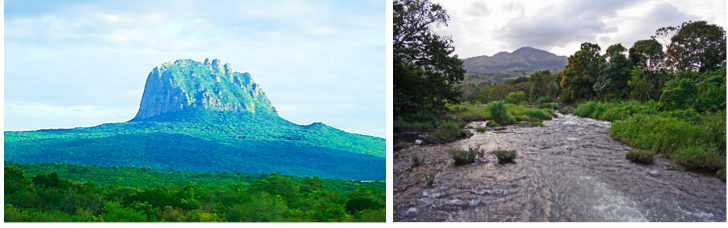
Figure 9. On the left is the hill Cerro Bernal in the state of Tamaulipas State;on the right is Cerro Vigia in the state of Veracruz.

And in the three hundred and fiftieth year we made a treaty with the Lamanites and the robbers of Gadianton, in which we did get the lands of our inheritance divided.
And the Lamanites did give unto us the land northward, yea, even to the narrow passage which led into the land southward. And we did give unto the Lamanites all the land southward. (Mormon 2:28–29; AD 350)
Don’t be concerned over Book of Mormon geography. Some say the Hill Cumorah was in southern Mexico (and someone pushed it down still farther) and not in western New York. Well, if the Lord wanted us to know where it was or where Zarahemla was, He’d have given us latitude and longitude, don’t you think? And why bother our heads trying to discover with archaeological certainty the geographical locations of the cities of the Book of Mormon like Zarahemla?16
The writers of the sacred record gave little space and did not make much of an effort to describe, in so many words, the physical features of the regions [of the Book of Mormon], wherein took place, the events they recorded. . . . If the time comes, or that it is expedient for the saints to have this information, it will come to them through the regularly established source, the prophet, seer, and revelator, the Presiding High Priest of the Church and no one else.17
It has been prophesied by our fathers that these things, . . . [which have] enlarged the memory of this people, should be kept and handed down from one generation to another, . . . preserved by the hand of the Lord until they should go forth unto every nation, kindred, tongue, and people, . . . [bringing them] to the knowledge of their God unto the salvation of their souls. (Adapted from Alma 37:4, 8.)
[1]. George Reynolds and Janne M. Sjodahl, Commentary on the Book of Mormon, 7 vols. (Salt Lake City: Deseret News Press, 1955), 1:214.
[2]. Alan C. Miner states that Mormon, the abridger of Alma’s record, is the author of the geography notes appearing in Alma 22:27–34. See his Step by Step through the Book of Mormon (Springville, UT: Cedar Fort, 1996).
[3]. Jerry L. Ainsworth, The Lives and Travels of Mormon and Moroni (n.p.: Peacemakers Publishing, 2000), 69.
[4]. See Ainsworth, The Lives and Travels of Mormon and Moroni.
[5]. John L. Sorenson, An Ancient American Setting for the Book of Mormon (Salt Lake City: Deseret Book and Provo, UT: Foundation for Ancient Research and Mormon Studies, 1996) and Mormon’s Codex: An Ancient American Book (Salt Lake City: Deseret Book and Provo, UT: Neal A. Maxwell Institute for Religious Scholarship, 2013).
[6]. See Ainsworth, The Lives and Travels of Mormon and Moroni, and Joseph Lovell Allen and Blake Joseph Allen, Exploring the Lands of the Book of Mormon, 2nd ed. rev. (American Fork, UT: Covenant Communications, 2011).
[7]. John E. Clark, “A Key for Evaluating Nephite Geographies,” FARMS Review 23, no. 1, 13–43.
[8]. See Ted Dee Stoddard, “From the East to the West Sea: An Analysis of John L. Sorenson’s Book of Mormon Directional Statements,” http://www.bmaf.org/articles/east_to_west_sea__stoddard.
[9]. Ainsworth, The Lives and Travels of Mormon and Moroni, 97.
[10]. Sorenson, An Ancient American Setting for the Book of Mormon, 42–44, 345.
[11]. David G. Hennessey, “The Narrow Neck of Land and the Narrow Pass: Where They Really Are and What It Really Means,” http://www.bmaf.org/articles/narrow_neck_narrow_pass__hennessey.
[12]. Sorenson, An Ancient American Setting for the Book of Mormon, 43.
[13]. Ainsworth, The Lives and Travels of Mormon and Moroni, 66.
[14]. See Kirk Magleby, “River Sidon South to North,” http://bookofmormonresources.blogspot.com/2011/ 11/river-sidon-south-to-north.
[15]. See, for example, John E. Clark, “Archaeology and Cumorah Questions,” Journal of Book of Mormon Studies 13, nos. 1–2 (2004) and Allen and Allen, Exploring the Lands of the Book of Mormon.
[16]. Harold B. Lee, The Teachings of Harold B. Lee (Salt Lake City: Deseret Book, 1996), 156.
[17]. Reynolds and Sjodahl, Commentary on the Book of Mormon, preface.
[18]. Miner, Step by Step through the Book of Mormon.
[19]. Dallin H. Oaks, “The Historicity of the Book of Mormon,” FARMS Annual Dinner, Provo, UT, October 29, 1993, citing Jocelyn Gibb and Owen Barfield, Light on C. S. Lewis (New York: Harcourt and Brace, 1965), 26.