


Zarahemla: Its Size and Its Rise and Fall
The contents of all BMAF publications are the sole responsibility of the individual authors and therefore do not necessarily represent the views of BMAF or The Church of Jesus Christ of Latter-day Saints.
Zarahemla: Its Size and Its Rise and Fall
The geographic size of the city and land of Zarahemla depends on the time period being discussed in the Book of Mormon. A review of the various scriptures relating to the geographic size and growth of the city and the land of Zarahemla is very instructive in determining their probable location and, perhaps just as important, in determining where other major Book of Mormon cities or territories could have been located and could not have been located.
Book of Mormon analysts should be consistent in the terminology used to describe the sizes of the land of Zarahemla. For example, Kirk Magleby uses the term “local land of Zarahemla” for the lands surrounding the city.1 Ric Hauck, Joseph Allen, and Blake Allen use the term “lesser land of Zarahemla.”2 The Book of Mormon uses such terms as “land or city,” “the city,” or “the land of” or similar terminology.
Proposal: Book of Mormon analysts should follow the example of the Book of Mormon and use the descriptive term “city/land of” to indicate a particular city and the area supporting that specific city.3
Most references to the land of Zarahemla refer to the “local land,” “city/land,” or “lesser land” of Zarahemla. Whenever the largest area realized by the Nephites in the land southward is indicated, then it can appropriately be described as the “greater land of Zarahemla.” Any term for any size in between seems irrelevant because the growth from about 124–120 BC (its initial identifiable size) to Moroni’s time (about 72–56 BC when it reached its apogee) was so constant and rapid as to render useless any attempt at naming an intermediate size.
Clearly, David Swingler is correct in describing the limited nature of the Nephite experience in Mesoamerica: “They were little fish in a big pond full of many ferocious fish.”4A rereading of his article is very beneficial for all analysts who are seeking to understand the geography of the Book of Mormon.
Hopefully, this article about Zarahemla’s rise and fall will show not only that Swingler is correct in his analysis but also that the following statement is accurate:
No ancient ruin or city/area could have been a Nephite location north of the narrow strip of wilderness if it was built, or was in the process of being built, prior to about 120 BC, unless it was conquered or converted by the Nephites subsequent to this date.
The only exception to this conclusion is the area of the city and land of Zarahemla that encompassed a small area, about the size of the Salt Lake Valley, and that was located just north of and “by” the narrow strip of wilderness.
Therefore, most, if not all, of the Peten and Belize and all of the Yucatan Peninsula could not have been under Nephite control or occupation and were never part of the greater land of Zarahemla as described in the Book of Mormon.
History of the City and the Land of Zarahemla
Even though the Mulekites had a “first landing” (Alma 22:30), a statement that inherently implies a “second landing,” the Book of Mormon does not justify the belief that the Mulekites, or any subdivision thereof, lived in the place of their “first landing.” This conclusion is corroborated by the Book of Mormon itself:
Now there were not so many . . . of those who were descendants of Nephi, as there were of the people of Zarahemla, who was a descendant of Mulek, and those who came with him [Mulek] into the wilderness [about 580 BC]. (Mosiah 25:2)
[The people of Zarahemla] were brought by the hand of the Lord across the great waters, into the land where Mosiah discovered them; and they had dwelt there [at Zarahemla] from that time forth. (Omni 1:16)
Thus, the Lord guided Mulek and his people directly to the city/land of Zarahemla where they “dwelt there from that time forth.” During the next 350 years or so, their Jewish religion became defiled, and their language was modified to the extent that Mosiah1 could not initially understand them. They remained in this area until about 200 BC when King Mosiah1 fled from the city/land of Nephi, located just south of the narrow strip of wilderness, with “all those who would follow him” and merged with the people of the city/land of Zarahemla, which was located “by” (meaning “near”; see Alma 22:27) the northern part of the narrow strip of wilderness. Although the Mulekites had become “exceedingly numerous” prior to 200 BC, according to Amaleki, their growth was restricted:
At the time that Mosiah discovered them, they had had many wars and serious contentions, and had fallen by the sword from time to time; and their language had become corrupted; and they had brought no records with them; and they denied the being of their Creator; and Mosiah, nor the people of Mosiah, could understand them. (Omni 1:17)
The Size of Zarahemla, ca. 120 BC
The Book of Mormon gives no indication of the size of the Mulekite city or the land of Zarahemla until toward the end of King Benjamin’s reign, about 124 BC, when King Benjamin announced his retirement and the pending anointment of his son Mosiah2 to be king. The Book of Mormon scriptures also describe the limited physical size of the city and the land of Zarahemla at that time:
Therefore, he had Mosiah brought before him; and these are the words which he spake unto him, saying: My son, I would that ye should make a proclamation throughout all this land among all . . . the people of Zarahemla, and the people of Mosiah who dwell in the land [of Zarahemla], that thereby they may be gathered together; for on the morrow I shall proclaim unto this my people out of mine own mouth that thou art a king and a ruler over this people, whom the Lord our God hath given us. . . .
And now, it came to pass that Mosiah went and did as his father had commanded him, and proclaimed unto all the people who were in the land of Zarahemla that thereby they might gather themselves together, to go up to the temple to hear the words which his father should speak unto them. (Mosiah 1:10, 18)
And it came to pass that after Mosiah had done as his father had commanded him, and had made a proclamation throughout all the land [of Zarahemla], that the people gathered themselves together throughout all the land [of Zarahemla], that they might go up to the temple to hear the words which king Benjamin should speak unto them.
And there were a great number, even so many that they did not number them; for they had multiplied exceedingly and waxed great in the land [of Zarahemla].
And they also took of the firstlings of their flocks, that they might offer sacrifice and burnt offerings according to the law of Moses; . . .
And it came to pass that when they came up to the temple, they pitched their tents round about, every man according to his family, consisting of his wife, and his sons, and his daughters, and their sons, and their daughters, from the eldest down to the youngest, every family being separate one from another. (Mosiah 2:1–5)
A significant point here is that all the Nephites and all the people of Zarahemla had no more than a day to assemble to the temple in the city of Zarahemla.
Therefore, the size of the city and the land of Zarahemla at about 124 BC could not have been larger than the distance that a family with sacrificial animals and tents could have traveled in one day. Thus, the size of the city and the land of Zarahemla about the year 124 BC was apparently about 10 to 12 miles radius from the temple at Zarahemla. Perhaps that area was comparable to the size of the Salt Lake Valley from North Salt Lake to Draper and from Magna to Mount Olympus.
Some Book of Mormon analysts might claim that the term “on the morrow” need not mean merely one day. However, all analysts should remember that the Lord Himself told Nephi that “on the morrow come I into the world” (3 Nephi 1:13). Thus, in the Book of Mormon, the term “on the morrow” means one day
Four years later in 120 BC, the year after King Benjamin had died, after Ammon and friends had liberated Limhi and his Nephite subjects and returned from the land of Nephi, and also after Alma and his followers had arrived in Zarahemla, King Mosiah2 did the same thing his father had done:
Mosiah caused that all the people should be gathered together.
Now there were not so many of . . . those who were descendants of Nephi, as there were of the people of Zarahemla, who was a descendant of Mulek, and those who came with him into the wilderness. . . .
And now all the people of Nephi were assembled together, and also all the people of Zarahemla, and they were gathered together in two bodies. (Mosiah 25:1–4)
Unless “all” does not mean “every one, or the whole number of particulars”5 in this scripture, then the account indicates that the size of the city and the land of Zarahemla had not appreciably grown between 124–120 BC. Because all the Nephites and all the people of Zarahemla were living in this limited area at about 124 BC and 120 BC, then probably very few if any Nephites or Mulekites lived outside this area at that time. Therefore, the following conclusion should be true:
Any other area north of the narrow strip of wilderness that was developed or that was in the process of being developed on or before about 120 BC could not have been a Nephite city or land unless it was subsequently conquered or its people converted by the Nephites.
Therefore, the following ancient cities (ruins), among many more, could not have been Nephite cities because they all preexisted 120 BC and because the Book of Mormon contains no evidence that the Nephites were the aggressors and conquerors of the following areas:
El Mirador 1500 BC to AD 250
Lamanai 1500 BC to AD 1500
Tikal 300 BC to AD 900
Kohunlich Before 200 BC to after AD 600
Dzibanche About the same as Kohunlich
Nakbe 1400 BC to 100 BC
Palenque 226 BC to AD 1123
Cerros 400 BC to AD 400
Piedras Negras 600 BC to AD 800
El Ceibal 400 BC to AD 650
The conclusion also follows that the areas of Ammonihah, Noah, Melek, Manti, probably Gideon, and possibly Minon were not established until after about 120 BC because each was located about a day or more distance away from the city of Zarahemla.
Expansion of the Land of Zarahemla from 120 BC to ca. 85 BC
Notwithstanding the Amlicite civil war in 87 BC in which more than 12,500 Amlicite soldiers and 6,500 Nephite soldiers were killed, during the ensuing thirty-five years, from 120 BC to 85 BC, the land of Zarahemla grew in size to an area that included the following cities/lands:
· City/valley of Gideon located not more than about 15 miles southeast and up in elevation from Zarahemla. Gideon was located east of the river Sidon a half night’s march (not more than 5 miles across the river Sidon) from Minon.
· Minon was located not more than 15 miles south of, and up in elevation from, Zarahemla. Minon was located west of the river Sidon and not more than a half night’s march (5 miles across the river Sidon) from Gideon.
· The city of Manti was located not more than about 40 to 50 miles south of, and up in elevation from, Zarahemla within the northern edge of the narrow strip of wilderness.
· The city of Melek was located about a day or two west of Zarahemla (not more than about 25 miles).
· The city of Ammonihah was located north from Melek about 30 miles (about three days’ journey for the injured and aging Alma) or northwesterly from Zarahemla about 30 to 40 miles.
· The city of Noah was probably located near Ammonihah and between Ammonihah and Melek.
· The city of Sidom was probably located southeastward of Ammonihah toward the city/land of Zarahemla and probably near the river Sidon.6
These cities were all located surrounding the initial city/land of Zarahemla. Gideon did not become a city until after the Amlicite war of 87 BC (Alma 6:7). Within thirty-five years, about 85 BC, the land of Zarahemla had increased in size to about a 40- to 50-mile radius from the temple at Zarahemla. Expansion continued aggressively for about ten more years until just after 72 BC when the land of Zarahemla realized its greatest size under the stewardship of Captain Moroni, extending from the east sea to the west sea.
Expansion of Zarahemla to Its Greatest Size
References to the “greater land of Zarahemla” allude to the greatest extent of the land of Zarahemla, which occurred during Captain Moroni’s leadership (72 BC to about 56 BC). At this time, this territory included from the east sea (Gulf of Honduras) to the west sea (the Pacific Ocean). The territory included north along the east sea coast from the city/land of Moroni north not over 30 miles or so to the defensive city Bountiful near the east sea. And the territory also included the area along the Pacific coast northward from the narrow strip of wilderness to the line between Bountiful and Desolation. This “line” was probably located at a site called Horcones, Mexico, where evidence of a Preclassic man-made defensive wall has been located at a very strategic military location.7
The following map very roughly shows the greatest extent of the greater land of Zarahemla (in red) about 56 BC at the time of Captain Moroni’s death.
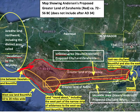
In the year 77 BC, notwithstanding that the Nephites did not yet have complete control over the east-sea area, the Ammonites were settled, by the Nephites, in the land of Jershon, which was located near the east sea and near the Zoramite city of Antionum. Until about 75 BC, the Nephites still did not control the east-sea area because they had not cleared out all the Lamanites who nearly surrounded the expanding land of Zarahemla. That does not mean Nephites were not living there; it means only that all the Lamanites had not yet been chased out. Certainly by 74 BC, the independent Zoramite/Nephites occupied the city/land of Antionum located near the eastern end of the narrow strip of wilderness adjacent to the Lamanite land south of the line within the narrow strip of wilderness that divided the greater land of Nephi from the greater land of Zarahemla.
By the end of 74 BC, the Zoramites had become Lamanites (Alma 43:4). In the year 72 BC, all the Lamanites (including the Zoramites if any were there) were chased out of the east-sea area. Therefore, Antionum could not have been located some 30 miles inside the greater land of Zarahemla but had to have been located right at the line of possession of the Lamanites.
Therefore, the following statement is respectfully made for the benefit of all Book of Mormon analysts who are interested:
From 120 to 72 BC, a period of less than fifty years, the Nephite nation (the greater land of Zarahemla) could not have occupied, controlled, or converted the Peten, Belize, or the Yucatan with their millions of Maya occupants during the zenith of their existence.
By 77 BC, the Nephites apparently were also inhabiting, or at least controlling, the northern part of the narrow strip of wilderness from Manti west to the west sea and all of the west-sea land Bountiful (the Pacific corridor) northward to the line between Bountiful and Desolation (see Alma 22:27–34).
Very likely, some Nephite cities had been developing near the west coast (“west sea south”; see Alma 53:8) much earlier than 200 BC. These cities included Judea, Antiparah, and the unnamed city on the west coast (Alma 56:30–31). Also very likely, not all of the righteous Nephites in the land of Nephi fled with Mosiah1 (about 200 BC). For example, some Nephites (during their 350 years in the greater land of Nephi) probably migrated westward to the area of their original landing near Izapa and began populating that area and northward along the west coast. These were probably the people responsible for engraving the tree-of-life stone at Izapa (about 300 BC). (This area was initially located just south of the narrow strip of wilderness, and the people must have been a mixture of Lamanites and Nephites and perhaps others, including the Izapian culture that also apparently included some Olmec remnants.) This area (and northward) probably eventually became the west-sea land Bountiful (the Pacific corridor).
At least by ca. 77 BC in this west-sea area, “the Nephites had inhabited the land Bountiful, even from the east unto the west sea” (Alma 22:33). When readers read verses 32 and 33 of Alma 22 together, they will see that the distance from the east to the west sea was the distance of about a day and a half from the east (Sierra Madre Mountains) to the west sea (Pacific Ocean).
The Decline of the Greater Land of Zarahemla, ca. 35 BC to AD 33
The greatest size of the greater land of Zarahemla did not last long. In the year 35 BC (about twenty years after Captain Moroni died), the Lamanites succeeded in overtaking all of the greater land of Zarahemla, and they controlled all of the land southward (Helaman 4:5–10).8The only exception was a small area near “the line” along the west-sea coast where Moroni’s son, Moronihah, was successful in defending “their north country” (the Jaredite land northward) for about two years. By the end of 31 BC, Moronihah was able to regain the northwestern half9 of the greater land of Zarahemla, probably the area west of the river Sidon (the Chixoy part of the Usumacinta, including the Ichbolay River). Therefore, everything east of the river Sidon and all of the east-sea cities, including cities Bountiful, Jershon, Moroni, Nephihah, Aaron, and probably Gideon, were still under Lamanite control.10
After about 29 BC, the Lamanites became more righteous than the Nephites, and a unity of trade and commerce took place between them. Thereafter, a military need no longer existed for the narrow strip of wilderness as a defensive line. This mountainous area then became the base for the Gadianton robbers. Thus, the east-sea area was no longer an important factor in protecting the greater land of Zarahemla. In fact, after 29 BC, nothing more is ever mentioned in the Book of Mormon about any city east of the river Sidon. The only exceptions are (1) at Christ’s crucifixion when the Lord stated that the city Moroni was sunk into the depths of the sea and (2) in 6 BC where readers are told, “Yea, and wo be unto the city of Gideon, for the wickedness and abominations which are in her” (Helaman 13:15). After 6 BC, the wickedness, abominations, and apostasy of the Nephites east of the Sidon were so great that nothing more of them is ever mentioned in the Book of Mormon.
The term “greater land of Zarahemla” is never used again. In fact, the only time the term “land of Zarahemla” is ever used again is in AD 322 when readers are told that Mormon was carried by his father “into the land southward, even to the land of Zarahemla” (see Mormon 1:6). This statement is clearly referring to the city/land of Zarahemla as emphasized in Mormon 1:6, which states that the final war of the Nephites began “in the borders of Zarahemla, by the waters of Sidon.” This final war clearly did not proceed toward the east sea; rather, it proceeded westward from the city of Zarahemla, located on the west of the river Sidon, to Angola, then to David, and then to Joshua, which was located “in the borders west by the seashore” (Mormon 2:6).
Book of Mormon analysts cannot discern whether an area that might have been known as the greater land of Zarahemla continued to exist during the 160 years of peace from AD 34 to AD 201. The city of Zarahemla was rebuilt (about AD 60; see 4 Nephi 1:6–7); however, the Nephite records obviously never remained there.
The Book of Mormon says nothing about the time the records were removed from Zarahemla. They were probably moved just before Zarahemla was destroyed by fire, likely during the time between AD 30 to 33 when the Nephites had no government or church because King Jacob had caused the people to be split up into tribes. The records were probably initially moved to the temple in the west-sea land Bountiful (probably at Izapa where Richard Hauck believes Christ first appeared) and then later moved to the Jaredite land northward. Certainly, the headquarters of the Church were eventually located in the Jaredite land northward where Mormon’s father, Mormon, lived and where Ammaron (about AD 322) also lived and maintained the records, perhaps near the hill Shim, which was located near Jashon/Jordan.
Apparently, the political capital of the Nephites returned to Zarahemla after it was destroyed by fire, inasmuch as the people living in the city of Zarahemla were the ones who appointed Mormon at age fifteen to be the leader of all the Nephite armies (AD 327). Also, Mormon probably never ventured across or eastward of the river Sidon because the final war began on the west of Sidon when Mormon was eleven (Mormon 1:10). By AD 329, Mormon (age eighteen) was defending the west-sea area at Joshua where he resided for more than fifteen years (Mormon 2:6, 9–15). In AD 345, Mormon (age thirty-four) was chased out of Joshua and the west-sea land Bountiful into the Jaredite land northward (Mormon 2:16–17). In AD 349, Mormon recovered the west-sea land Bountiful, at least back to Joshua (Mormon 2:27). Then, in AD 350, Mormon entered into a treaty wherein he gave up all claim to the entire land southward of the line between Bountiful and Desolation (Mormon 2:29). At that point, the Nephite land of Zarahemla ceased to exist.
No attempt is made in this article to describe the size of the Nephite-occupied Jaredite land northward because it was never a part of the greater land of Zarahemla. For a description of this proposed land and size, see my article on the Nephites and the Epi-Olmec.11In this article, the proposal is made that the Nephites became a part of the Epi-Olmec culture within the Isthmus of Tehuantepec area.
Conclusion
Based upon the Book of Mormon’s description of the rise and fall of the land of Zarahemla, the physical domain of the Nephite nation must have been relatively small in comparison to the size of all the land southward of the line between Desolation and Bountiful. The Nephites made a valiant effort in preserving themselves while being surrounded by myriads of highland and lowland Maya and many other cultures along the Pacific coastal corridor. They were indeed “little fish in a big pond full of many ferocious fish.” The Nephites never did occupy or control the Peten, Belize, or the Yucatan Peninsula.
As will be corroborated in a subsequent article in response to Kirk Magleby’s “Book of Mormon Model,”12 the city/land of Zarahemla could not have been located near the lower Usumacinta River or at or near the area between Palenque and Balancan, Magleby’s proposed local land of Zarahemla, nor could the “land Bountiful,” a small part of the greater land of Zarahemla, have been located in the Yucatan.13
Notes
1. See Kirk Magleby, “Book of Mormon Trifecta,” http://bmaf.org/node/459, and Kirk Magleby, “Book of Mormon Model,” http://bookofmormonresources.blogspot.com/2012/07/book-of-mormon-model.html.
2. See F. Richard Hauck, Deciphering the Geography of the Book of Mormon (Salt Lake City: Deseret Book, 1988) and Joseph Lovell Allen and Blake Joseph Allen, Exploring the Lands of the Book of Mormon, 2nd ed. rev. (American Fork, UT: Covenant Communications, 2011).
3, The Book of Mormon uses the terms “city” or “land of” to refer to a specific city and the supporting lands immediately surrounding that specific city, as the following scriptures (among many others) show:
· City, or the land, Nephihah: And they also began a foundation for a city between the city of Moroni and the city of Aaron, joining the borders of Aaron and Moroni; and they called the name of the city, or the land, Nephihah (Alma 50:14).
· Land, or the city, of Zarahemla: They have got possession of the land, or the city, of Zarahemla (Alma 61:8).
· Your cities, your lands: Therefore I write unto you, desiring that ye would yield up unto this my people, your cities, your lands, and your possessions (3 Nephi 3:6).
· Land, or even the city: And ye all are witnesses this day, that Zeniff, who was made king over this people, he being over-zealous to inherit the land of his fathers, therefore being deceived by the cunning and craftiness of king Laman, who having entered into a treaty with king Zeniff, and having yielded up into his hands the possessions of a part of the land, or even the city of Lehi-Nephi, and the city of Shilom; and the land round about (Mosiah 7:21).
· Land, or the city: And it came to pass that after the Lamanites had finished burying their dead and also the dead of the Nephites, they were marched back into the land Bountiful; and Teancum, by the orders of Moroni, caused that they should commence laboring in digging a ditch round about the land, or the city, Bountiful (Alma 53:3).
4. See David Swingler’s article, “Looking at the ‘Maya Problem’ from a Different Perspective,” http://www.bmaf .org/articles/maya_problem_different_perspective__swingler. See also Doug Christensen’s article, “Were the Lehites Big Fish in a Little Pond, or Little Fish in a Big Pond?” http://www.bmaf.org/articles/lehites_fish_pond__ christensen.
In his article, Swingler says the following (emphasis added):
I hope in this brief essay I have explained the perceptions I see as I look at the thousand years of the “Lehiaic Invasion” and its minimal impact on the evolving histories of the indigenous peoples, and how the massive impact of these “Goyim” or “Lamanites” upon the Lehiaic Group, led unto its utter destruction. We can see it today: they were little fish in a big pond full of many ferocious fish. It is a miracle they survived in this milieu for 1,000 years.
I continue to see in everything we know of Mesoamerica an archaeological effort less than 1% of that expended in Biblical lands, where even now, entire civilizations are still being discovered beneath 30 and more feet of built-up mud and dirt, in barren, unobstructed lands where visibility on clear days reaches to the horizons. I see thus a dearth of evidences in Mesoamerica, due first to comparatively minimal search efforts, compounded by the jungle conditions which enormously obstruct discovery. I see every reason to find in the “Goyim” or “Lamanites” of the Book of Mormon Record ALL of the peoples in Mesoamerica whose remains and archaeological evidences we see HAVE been found, and find it amazing the Lehiaic Invasion survived as long as it did in this world. Truly, they were protected by the Hand of God. Respectfully submitted, David H. Swingler
5. Noah Webster, An American Dictionary of the English Language (New York: S. Converse, 1828), s.v. “all.”
“This word signifies Switch to plain text editorthen, the whole or entire thing, or all the parts or particulars which compose it.”
“All” is used twelve times in Mosiah 1 and 2, in its whole, inclusive literal sense: “no contention in all the land of Zarahemla among all the people who belong to king Benjamin”; continual peace all the remainder of his days”; “they should be taught in all the language of his fathers”; “make a proclamation throughout all this land among all this people, or the people of Zarahemla and the people of Mosiah”; “he gave him charge of all the affairs of the kingdom”; “he did as his father had commanded him, and proclaimed unto all the people who were in the land of Zarahemla”; “proclaimed unto all the people who were in the land of Zarahemla.”
Four years after his father’s death, Mosiah2 again called all (used in the literal sense) his people together: “Mosiah caused that all the people should be gathered together”; “Now all the people of Nephi were assembled together, and also all the people of Zarahemla, and they were gathered together in two bodies.”
After defining the word all, Webster in his 1828 dictionary, says the following: “[The word all,] not only in popular language, but in the scriptures, often [but not always] signifies, indefinitely, a large portion or number, or a great part. Thus, all the cattle in Egypt died; all Judea and all the region round about Jordan; all men held John as a prophet; are not to be understood in a literal sense, but as including a large part or very great numbers” (emphasis added).
With Webster’s 1828 definition and comments about “all” in mind, Book of Mormon analysts must be careful in discerning whether the referent for any specific use of “all” in the Book of Mormon is an entire geographic territory or group of people “in a literal sense” or merely “a large part or very great number.”
However, even if “all” means “a large portion or a very great number,” in this scripture, Mosiah 25:1–4, then it still defines King Benjamin’s principal polity of the land of Zarahemla, “all the people who belong to king Benjamin,” to be a very limited size—a one day’s journey for a family with its tents and sacrificial animals in tow.
6. For the scriptures and analyses confirming the cities/lands, see my article, “Footprint of Zarahemla: Article One, Misinformation about Book of Mormon Geography,” http://www.bmaf.org/articles/footprints_Zarahemla_one __andersen.
7. See my article, “Footprint of Zarahemla: Article Two, The Narrow Strip of Wilderness: How close to Zarahemla Was It?” http://www.bmaf.org/articles/footprints_zarahemla_two__andersen.
8. Helaman 4:5–10 (emphasis added):
And in the fifty and seventh year [35 BC] they did come down against the Nephites to battle, and they did commence the work of death; yea, insomuch that in the fifty and eighth year of the reign of the judges they succeeded in obtaining possession of the land of Zarahemla; yea, and also all the lands, even unto the land which was near the [west-sea] land Bountiful.
And the Nephites and the armies of Moronihah were driven even into the land of [west-sea] Bountiful;
And there they did fortify against the Lamanites, from the west sea, even unto the east; it being a day’s journey for a Nephite, on the line [between Desolation and Bountiful] which they had fortified and stationed their armies to defend their north country [Jaredite land northward].
And thus those dissenters of the Nephites, with the help of a numerous army of the Lamanites, had obtained all the possession of the Nephites which was in the land southward. And all this was done in the fifty and eighth and ninth years of the reign of the judges. [Therefore, the only place they could have occupied and still be in the land southward was at the line between Bountiful and Desolation.]
And it came to pass in the sixtieth year of the reign of the judges, Moronihah did succeed with his armies in obtaining many parts of the land; yea, they regained many cities which had fallen into the hands of the Lamanites.
And it came to pass in the sixty and first year of the reign of the judges [31 BC] they succeeded in regaining even the half of all their possessions.
9. The scriptures and rationale supporting the conclusion that Moronihah recovered the northern and western half of the greater land of Zarahemla, including the city of Zarahemla, are as follows:
[In 35 BC, the dissenters and the Lamanites] succeeded in obtaining possession of the land of Zarahemla; yea, and also all the lands even unto the land which was near the land Bountiful.
And the Nephites and the armies of Moronihah were driven even into the land of Bountiful;
And there they did fortify against the Lamanites from the west sea, even unto the east; it being a day's journey for a Nephite, on the line which they had fortified and stationed their armies to defend their north country.
And thus those dissenters of the Nephites with the help of a numerous army of the Lamanites, had obtained all the possession of the Nephites which was in the land southward. (Helaman 4:5–8; emphasis added)
Only one “line” is described in the Book of Mormon as dividing Desolation from Bountiful. That line went from the “east to the west sea” and is the line between the west-sea land Bountiful and the land Desolation. Therefore, Moronihah must have been located at that line on or near the west sea. This had to have been the northwestern most part or border of the land southward. This was finally accomplished in the year 33 BC. The next year, 32 BC, Moronihah was able to recover many lands and many cities, commencing from the northwestern most part of the land southward where he had taken refuge. He must have been working his way southeastward down the Pacific coast (west-sea land Bountiful) and then eastward into the interior toward the capital city of Zarahemla, which was located in the “center of the land” (Helaman 1:27). Then, speaking of events that took place in 31 BC, Mormon says the following: “And it came to pass in the sixty and first year of the reign of the judges they succeeded in regaining even the half of all their possessions” (Helaman 4:10).
Readers can reasonably conclude that Moronihah did not skip over the city of Zarahemla to the east sea and then start recovering the lands from the east sea toward the west sea when the scripture never says they were near the east sea. Clearly, they were located near the west sea at the line between Desolation and the west-sea land Bountiful. Therefore, if Zarahemla was located about in the center of the land and if Moronihah began recovering his fallen cities even to the half of them, he must have recovered the northwestern half of the greater land of Zarahemla. Thus, he was unable to recover anything east of the river Sidon. Clearly, the half they recovered included the city of Zarahemla because Nephi delivered the judgment seat to Cezoram, indicating that at that time (30 BC), Nephi was living in Zarahemla and was still the chief judge until he lost the election (see Helaman 5:1).
10. By this time, I personally believe that the lowland Maya were probably mixing with the Lamanites and that together they were controlling the east-sea area.
11. See “Nephites and the Epi-Olmec (in the Isthmus 100 BC to AD 400),” http://www.bmaf.org/articles/nephites_ epi_olmecs__ andersen.
12. See Magleby, “Book of Mormon Model,” http://bookofmormonresources.blogspot.com/2012/07/book-of-mormon-model.html.
13. See Allen and Allen, Exploring the Lands of the Book of Mormon.