


“Southward”: How It Is Used in the Book of Mormon
“Southward”: How It Is Used in the Book of Mormon
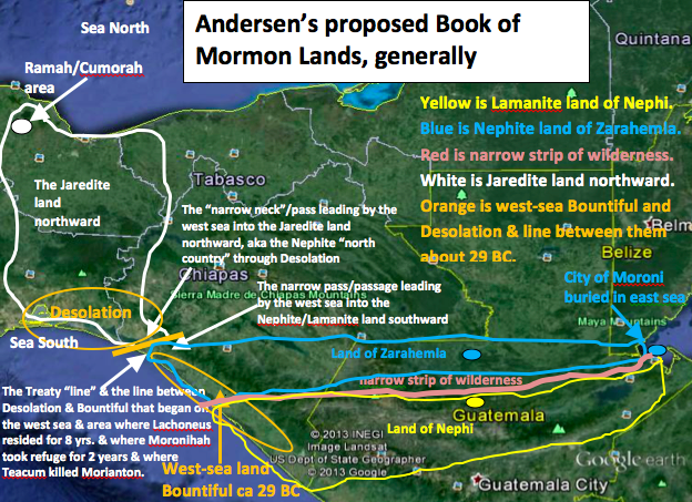
In “Deciphering the Geography of the Book of Mormon,” 1 Book of Mormon readers must understand the various usages of the word “southward.” In this article, all Book of Mormon scriptures that use the word “southward” are cited, and a description is given of how each is used.
Alma 22:31: Thus the land on the northward [of the “line”; see verse 32 below] was called Desolation, and the land on the southward [of the “line”] was called Bountiful, it [Bountiful] being the wilderness which is filled with all manner of wild animals of every kind, a part of which had come from the land northward [Jaredite land northward] for food.
Alma 22:32: And now, it was only the distance of a day and a half’s journey for a Nephite, on the line [“between”; see 3 Nephi 3:23] 5 Bountiful [hereafter this Bountiful will be called the west-sea land Bountiful] and the land Desolation, from the east to the west sea; and thus 6 the land of Nephi [Lamanites south of the narrow strip of wilderness] and the land of Zarahemla [Nephites north of the narrow strip of wilderness] were nearly surrounded by water, there being a small neck of land between the land northward and the land southward.
Helaman 3:8: And it came to pass that they did multiply and spread, and did go forth from the land southward to the land northward, and did spread insomuch that they began to cover the face of the whole earth, from the sea south to the sea north, from the sea west to the sea east.
Heleman 4:6-8: And the Nephites and the armies of Moronihah were driven even into the land of Bountiful [from the land of Zarahemla]; And there they did fortify against the Lamanites, from the west sea even, unto the east; it being a day's journey for a Nephite, on the line [between Desolation and Bountiful] which they had fortified and stationed their armies to defend their north country [meaning Desolation and the rest of the Jaredite land northward] And thus those dissenters of the Nephites, with the helep of a numerous army of the Lamanites, had obtained all the possession of the Nephites which was in the land southward [everything south of the "line" between Desolation and Bountiful]. And all this was done in the fifty and eighth and ninth years if the reign of the judges.
Helaman 5:16: [Nephi and Lehi visited all of the Nephites beginning at city Bountiful,] even from one city to another, until they had gone forth among all the people of Nephi who were in the land southward; and from thence into the [city/]land of Zarahemla, among the Lamanites.
Mormon 1:6: And it came to pass that I, being eleven years old, was carried by my father into the land southward, even to the land of Zarahemla. [In this case, the “land of Zarahemla” was the city/land of Zarahemla because it was here that Mormon resided and was appointed captain of all the Nephite armies at age fifteen.]
Mormon 2:28–29: In the three hundred and fiftieth year we made a treaty with the Lamanites and the robbers of Gadianton, in which we did get the lands of our inheritance divided. And the Lamanites did give unto us the land northward [of the “line”], yea, even to [not in] the narrow passage which led into the land southward. And we did give unto the Lamanites all the land southward [of the line including the narrow passage that led into the land southward].
Mormon 3:5: And it came to pass that I did cause my people that they should gather themselves together at the land Desolation, to a city which was in [within] the borders [of the land Desolation], by [near but not in] the narrow pass which led into the land southward [because this pass had been given to the Lamanites and robbers by treaty].
Alma 17:1: And now it came to pass that as Alma was journeying from the land of Gideon southward, away to the land of Manti, behold, to his astonishment, he met with the sons of Mosiah journeying [northward from Manti] towards the land of Zarahemla.
Helaman 11:20: And thus it did come to pass that the people of Nephi [this now included most of the Lamanites] began to prosper again in the land [southward], and began to build up their waste places, and began to multiply and spread, even until they did cover the whole face of the land, both on the northward [of the narrow strip of wilderness] and on the southward [of the narrow strip of wilderness], from the sea west to the sea east. [This was the time when the “more part of the people, both the Nephites and the Lamanites, did belong to the church” (see verse 21).]
3 Nephi 3:23–24: And the land which was appointed was . . . the land Bountiful, yea, to the line which was between the land Bountiful and the land Desolation. And there were a great many thousand people who were called Nephites, [Nephite and Lamanite armies (see verse 14)] who did gather themselves together in this land. Now Lachoneus did cause that they should gather themselves together in the land southward [of the “line”], because of the great curse which was upon the land northward. [Lachoneus and the people would have gone into the Jaredite land northward but for this great curse.]
3 Nephi 6:2: And it came to pass that they had not eaten up all their provisions; therefore they did take with them all that they had not devoured, of all their grain of every kind, and their gold, and their silver, and all their precious things, and they did return to their own lands and their possessions, both on the north and on the south, both on the land northward and on the land southward [of the narrow strip of wilderness].
3 Nephi 8:11–12: And there was a great and terrible destruction in the land southward [of the narrow strip of wilderness]. But behold, there was a more great and terrible destruction in the land northward [of the narrow strip of wilderness]; for behold, the whole face of the land [land northward of the narrow strip of wilderness] was changed, because of the tempest and the whirlwinds, and the thunderings and the lightnings, and the exceedingly great quaking of the whole earth [meaning in the areas north and south of the narrow strip of wilderness].
Ether 9:31: And there came poisonous serpents also upon the face of the land [Jaredite land northward], and did poison many people. And it came to pass that their flocks began to flee before the poisonous serpents, towards [not “in” yet] the land southward, which was called by the Nephites Zarahemla.
Ether 9:32: And it came to pass that there were many of them [beasts, see verse 34] which did perish by the way; nevertheless, there were some [beasts or animals of the forest] which fled into the land southward. [This verse does not mean that the beasts or animals of the forest occupied the entire territory of the land southward. And if the only reasonable entrance into the land southward from the land northward was via the west sea corridor, then the animals must have entered into the west-sea land Bountiful.]
Ether 9:33: The Lord did cause the serpents that they should pursue them [the beasts or wild animals of every kind] no more, but that they should hedge up the way that the people could not pass, that whoso should attempt to pass might fall by the poisonous serpents. [The people could not follow the animals into the land southward (that part called Bountiful) until the Lord removed the serpents in the days of King Lib.]
Ether 10:19: And it came to pass that Lib also did that which was good in the sight of the Lord. And in the days of Lib the poisonous serpents were destroyed. Wherefore they did go into the land southward [beginning at the “line” between Desolation and Bountiful], to hunt food for the people of the land [living north of the “line”], for the land [south of the line] was covered with animals of the forest. And Lib also himself became a great hunter.
Ether 10:20–21: And they built a great city by the narrow neck of land, by the place where the sea divides the land. And they did preserve the land southward [of the “line”] for a wilderness, to get game. And the whole face of the land northward was covered with inhabitants [everything northward from the “line”]. [This city was built within the Jaredite land northward just north of the “line” near the entryway into the Bountiful part of the land southward.]
[1]. Deciphering the Geography of the Book of Mormon is the title of F. Richard Hauck’s book published in 1988 (Salt Lake City: Deseret Book). Via this book, he is the first Book of Mormon scholar to identify most of the geographic conclusions contained in this article.
[2]. See my article entitled “Three Separate Lands Bountiful: Where Located? What Size? To Which Bountiful Did Christ First Appear?” (http://www.bmaf.org/articles/three_bountifuls__andersen).
[3]. According to Alma 22:34, “The Lamanites could have no more possessions only in the land of Nephi and the wilderness round about.” This did not happen until about 72 BC after Moroni had forced all the Lamanites out of all areas north of the narrow strip of wilderness to south of the narrow strip of wilderness. Therefore, this geographic recap has to be referencing about 72 BC and prior. Moroni did not appear until about 74 BC (see Alma 43:16).
[4]. Under the assumptions that Mormon was consistent in the way he used the term “the land southward” and that Bountiful was a part of the land southward, then the point at which the animals entered into the land southward from the land northward must have been at the “line” between Desolation and Bountiful. Readers should remember also that Mormon describes a “narrow pass” and a “narrow neck” that led from the “line” by the west sea into the land northward:
Alma 50:34 [talking about Teancum stopping Morianton before Morianton could get into the Jaredite land northward]: And it came to pass that they did not head them until they had come to [not in] the borders of the land Desolation; and there they did head them, by [not in] the narrow pass which led by the [west] sea into the land northward, yea, by the sea, on the west.
Alma 63:5: Hagoth . . . built him an exceedingly large ship, on [within] the borders of the land Bountiful by [near but not in] the land Desolation, and launched it forth into the west sea, by [near but not in] the narrow neck which led into the land northward.
Mormon also describes a “narrow passage” and a “narrow pass” that led from the same “line” into the land southward:
Mormon 2:29: And the Lamanites did give unto us the land northward, yea, even to [not in] the narrow passage which led into the land southward. And we did give unto the Lamanites all the land southward.
Mormon 3:5: And it came to pass that I did cause my people that they should gather themselves together at the land Desolation [therefore near the west sea], to a city which was in the borders [of land Desolation], by [but not in] the narrow pass which led into the land southward.
If there was a narrow neck or narrow pass that led into the land northward and a narrow passage or pass that led into the land southward, if the Jaredite land northward was divided from the Nephite land southward by a “small neck of land” (Alma 22:32), if Desolation was a part of the land northward and Bountiful was a part of the land southward, and if there was a “line” (about a day and a half in length from the east to the west sea) between Desolation and Bountiful, then that “line” must have been located within the “small neck of land.” It then stands to reason that it must also have been where the two narrow passes or passages met, one going northward through Desolation into the land northward and the other going southward through Bountiful into the land southward.
This being the case, then the conclusion seems inescapable that “the narrow neck of land” referred to in Ether 10:20 must have been that same narrow neck or pass or passage that led by the west sea into the lands northward and southward and therefore could not have been the Isthmus of Tehuantepec. This thinking is confirmed by Ether 10:19–21, which states:
Ether 10:19–21: And it came to pass that Lib also did that which was good in the sight of the Lord. And in the days of Lib the poisonous serpents were destroyed. Wherefore they did go into the land southward, to hunt food for the people of the land, for the land [Bountiful; see Alma 22:31] was covered with animals of the forest. And Lib also himself became a great hunter. And they built a great city by [near but not in] the narrow neck of land [that led by the west sea into the land southward], by [near but not in] the place where the sea divides the land. And they did preserve the land southward [from the line separating Desolation from Bountiful] for a wilderness, to get game. And the whole face of the land northward was covered with inhabitants. [Therefore, the entire Isthmus and northward to the Papaloapan Basin was covered with inhabitants, but the narrow neck of land and southward was covered only with game.]
What follows from this conclusion is that the city Desolation and the “place where the sea divides the land” must also have been located by the west sea just northward from the “line” because only one entrance into the lands northward/southward is described in the Book of Mormon. And there is only one area called Desolation, and that is also where the Nephites cast the bodies of the dead Lamanites into the sea.
From these conclusions, readers can further deduce that this “line” must have been where the animals from the land northward entered into the land southward beginning at Bountiful. And it was also where the poisonous serpents were finally able to stop the Jaredites from entering into the land southward:
Ether 9: 32: There were many of them [beasts] which did perish by the way; nevertheless there were some which fled into the land southward.
Another conclusion also follows that not only this “line” was where the snakes in Ether 9:33 were able to “hedge up the way” that the people could not pass into the land southward but also it must have been the place where the righteous King Lib was able to protect and preserve the land southward from competitors and maintain it as his place for hunting food for his people. (This event occurred about the year 800 BC and, of course, was about two hundred years before Lehi landed within the west-sea land Bountiful about 588 BC.) King Lib ruled in Moron from about 900 to 800 BC (eleven generations before Ether and Coriantumr; see Ether 1:6–18). (See also Joseph L. and Blake J. Allen’s time analysis, Exploring the Lands of the Book of Mormon, 2nd ed. rev. [American Fork, UT: Covenant Communications, 2011], 119.)
[5]. 3 Nephi 3:23: And the land which was appointed was the land of Zarahemla, and the land which was between the land Zarahemla and the land Bountiful, yea, to the line which was between the land Bountiful and the land Desolation
[6]. Alma 22:27–35 (referred to by some scholars as “Mormon’s Map”): Verses 27 through the first sentence of verse 31 of Alma 22 apparently indicate Mormon’s understanding of the geography of these lands as it existed about Captain Moroni’s time (about 72 BC; see endnote 2) when Moroni created the protectable division between the Nephites and the Lamanites at the narrow strip of mountainous wilderness that extended from the east sea to the west sea. Therefore, the sentence in verse 31 beginning with “Thus” should begin a new verse because following this is a summary conclusion of the previous statements. This new verse is denoted in this article as “31a.” Mormon apparently wanted his readers to understand Alma 22:27–35 as follows (note that this description begins before Moroni divided the lands along the narrow strip of wilderness and ends after the division because it begins with the Lamanites still in the east wilderness north of the narrow strip of wilderness and ends after they have “all” been driven to their own lands south of the narrow strip of wilderness):
27. And it came to pass that the king sent a proclamation throughout all the land [of Nephi], amongst all his people who were in all his land, who were in all the regions round about, which [land of Nephi] was bordering even to the sea, on the east [of Nephi] and on the west [of Nephi], and which [land of Nephi] was divided from the land of Zarahemla by a narrow strip of wilderness, which [narrow strip of wilderness] ran from the sea east [of Nephi] even to the sea west [of Nephi], and [the narrow strip of wilderness continued] round about on the borders of the [west] seashore, and the borders [of that part] of the [narrow strip of] wilderness which was [located] on the north by the land of Zarahemla, [continued] through the borders of Manti, by the head of the river Sidon, [the borders of the narrow strip of wilderness continued] running from the east towards the west—and thus were the Lamanites and the Nephites divided. [The narrow strip of wilderness divided them—not the river Sidon.]
28. Now, the more idle part [distinguishing from the majority who lived in the city/land of Nephi, which was located south of the narrow strip of wilderness] of the Lamanites lived in the [narrow strip of mountainous] wilderness, and dwelt in tents; and they [the idle Lamanites] were spread through the wilderness on the west [the western and southern part of the narrow strip of wilderness, and therefore], in the land of Nephi; yea, and also on the west of the land of Zarahemla, in the borders by the seashore [because these idle Lamanites were spreading west of the city/land of Zarahemla, then they were beginning to surround the Nephites on their western side], and on the west in the land of Nephi, [therefore south of the narrow strip of wilderness] in the place of their [the Lamanite] fathers’ first inheritance, and thus bordering along by the seashore [the west seashore south of the narrow strip of wilderness (see Helaman 6–10 where “the Lord did bring Mulek into the land north and Lehi into the land south” of the narrow strip of wilderness); see endnote 11].
29. And also there were many Lamanites on the east [from the city/land Zarahemla] by the seashore, whither the Nephites had driven them. [The east-sea Bountiful and none of the east-sea cities had been built at this time.] And thus the Nephites were nearly [on three sides, south, east, and west] surrounded by the Lamanites; nevertheless the Nephites had taken possession of all the northern parts of the land bordering on the [narrow strip of] wilderness, at [from] the head of the river Sidon, from the east to the west, round about on the [western] wilderness side [of the narrow strip of wilderness]; on the north [of the western part of the narrow strip of wilderness], even until they [Nephites] came to the land which they called Bountiful. [Therefore, this west-sea land Bountiful was deemed by Mormon as a land distinct from the land of Zarahemla, and it was located northward from the narrow strip of wilderness. Also, because the Nephites were already in possession of the city/land of Zarahemla, then this new land that they “had taken possession of” must be referring to that land that was west of the city/land of Zarahemla and northerly from the western part of the narrow strip of wilderness.]
30. And it [Bountiful] bordered upon the land which they [the Nephites] called Desolation, it [Desolation] being so far northward that it [Desolation] came into the land which had been peopled and been destroyed, [this precludes any possibility that the Jaredites could have lived in the Central America area and then traveled to a different land northward to have their final battles because this says they were destroyed in the same land where they had lived] of whose bones we have spoken, which [Jaredite land northward] was discovered by the people of Zarahemla, it [Jaredite land northward] being the place of their first landing.
[The interpretation seems more clear and reads better if the next sentence were a part of verse 30 because it is still talking about the people of Zarahemla.] And they [the people of Zarahemla] came from there [place of first landing] up into the south wilderness [the wilderness south of the Jaredite land northward known as Zarahemla because the Lord guided them directly to Zarahemla where they remained ever since]. [When going southward from anywhere in the Isthmus of Tehuantepec, except the seashores, travelers must move upward in elevation. This is another indicator that the Jaredite land northward was, in fact, the Isthmus of Tehuantepec because from anywhere in the isthmus northward, except along the seashore, travelers must move upward. Therefore, if the Jaredite land northward were located northward from the isthmus, then the Mulekites would necessarily have moved downward and crossed the Coatzacoalcos before going up into the wilderness, at that time, south of the Isthmus.]
31.Thus the land on the northward [of the line; see 32] was called Desolation, and the land on the southward [of the line] was called Bountiful, it [Bountiful] being the wilderness which is filled with all manner of wild animals of every kind, a part of which had come from the land northward [including Desolation] for food.
32. And now, it was only the distance of a day and a half’s journey for a Nephite, on the line [between] Bountiful and the land Desolation, from the east to the west sea; [The line went from a boundary—not a sea—in an east-to-west direction to the west sea.] [Because the next independent clause in this sentence brings the land of Nephi back into the discussion, then a new paragraph should begin, which seems to be a geographic conclusion from the preceding six verses.]
32a. And thus the land of Nephi and the land of Zarahemla [the greater land southward] were nearly surrounded by water, there being a small neck of land between the land northward [including Desolation] and the land southward [including Bountiful].
33. And it came to pass that the Nephites had inhabited the [west-sea] land Bountiful, even from the east [boundary, not a sea] unto the west sea, and thus the Nephites in their wisdom, with their guards and their armies, had hemmed in the Lamanites on the south [of the narrow strip of wilderness], that thereby they [the Lamanites] should have no more possession on the north [of the narrow strip of wilderness], that they might not overrun the land northward [probably meaning from the narrow strip of wilderness and everything northward from there, including the Jaredite land northward into which the Nephites were just beginning to migrate.]
34. Therefore the Lamanites could have no more possessions only in the land of Nephi, [which in 72 BC included only everything south of the narrow strip of mountainous wilderness] and the [western part of the narrow strip of] wilderness round about. Now this was wisdom in the Nephites—as the Lamanites were an enemy to them, they would not suffer their afflictions on every hand, and also that they might have a country [west-sea Bountiful and the Jaredite land northward] whither they might flee, according to their desires.
35. And now I, after having said this, return again to the account of Ammon and Aaron, Omner and Himni, and their brethren.
[7]. See Exploring the Lands of the Book of Mormon, 307, where Joseph and Blake Allen say, “The country or greater land Bountiful was synonymous with the land southward.” Allen and Allen cite Alma 22:31 as justification for this statement: “Thus the land on the northward was called Desolation, and the land on the southward was called Bountiful.”
[8). Ether 7:6 says, “Now the land of Moron where the King dwelt was near [not in] the land which is called Desolation by the Nephites.”
[9]. Helaman 4:5–7 (35 BC): [The dissenters and the Lamanites] succeeded in obtaining possession of the [city/]land of Zarahemla; yea, and also all the lands even unto the land which was near [but not in yet] the [west sea] land Bountiful. And the Nephites and the armies of Moronihah were driven even into the land of Bountiful; And there they did fortify against the Lamanites from the west sea, even unto the east; it being a day’s journey for a Nephite, on the line which they had fortified and stationed their armies to defend their north country. (Clearly, the land Bountiful was considered a separate land from the city/land of Zarahemla by the writers of the Book of Mormon.)
[10]. Mormon states in Alma 50:11 that the Nephites possessed all the land northward of the west-sea land Bountiful. This territory was called the land Desolation by the Nephites and was the entryway into the Jaredite land northward. Therefore, by 72 BC, the Nephites had begun to migrate into the Jaredite land northward—or, more specifically, to “their [the Nephites’] north country.”
[11]. See my article, “‘The Land North’ Always Means North of The Narrow Strip of Wilderness” (http://www.bmaf.org/articles/land_north_narrow_strip__andersen). “The land north” never refers to territory north of the narrow neck of land.
[12]. Again, see my article, “‘The Land North’” Always Means North of The Narrow Strip of Wilderness” (http://www.bmaf.org/articles/land_north_narrow_strip__andersen). “The land north” always means north of the narrow strip of wilderness and never north of the narrow neck of land.
[13]. Mormon 2:29: The Lamanites did give unto us the land northward, yea, even to [but not including] the narrow passage which led into the land southward. And we did give unto the Lamanites all the land southward [including the narrow passage].
Mormon 3:5: I did cause my people that they should gather themselves together at the land desolation, to a city which was in the borders, by [but not in] the narrow pass which led into the land southward [because the Nephites had already given that territory to the Lamanites].
[14]. During the Book of Mormon time period, the only reasonable route between Central Guatemala and the Isthmus of Tehuantepec was the Pacific coastal route. Because the land Desolation was part of the Jaredite land northward (and it began on the west sea), because the west-sea land Bountiful was part of the land southward (and it also began on the west sea), and because there was a “line” between them that ran in an easterly direction from the west sea about twelve miles or so, then that “line” between them must have been part of and within the small neck of land that divided the Jaredite land northward from the Nephite/Lamanite land southward as described in Hauck, Deciphering the Geography of the Book of Mormon, 145–47. This “line” must have been the gateway that connected the narrow neck/narrow pass leading by the west sea into the Jaredite land northward with the narrow pass/passage that led by the west sea into the greater land southward.
My colleague Ted Stoddard identified this west-sea corridor as the main commercial and “only reasonable” passageway from the narrow strip of wilderness area to the Jaredite land northward. He explained this in an email he sent to me on August 2, 2010: “For centuries, the only reasonable way to get from Chiapas or Guatemala to Veracruz, Oaxaca, or the Mexico valley was to end up on the Pacific coast and go north through the Isthmus of Tehuantepec. About fifty miles into the isthmus, the topography opens up, permitting travelers to continue to Veracruz or to follow trails into the mountains and thence to the Oaxaca or Mexico areas. In a similar vein, travelers from the east wilderness (lowland jungle area of the Peten and Belize) or from the east sea (Caribbean off the coast of Belize) could not travel due west to go through the top of the isthmus because of (1) the mountainous terrain, especially in the Hermounts region at the top of and east of the isthmus or (2) the marshy lagoons and rivers of Tabasco that made east-west travel almost impossible until the arrival of modern highways.”
Hauck agrees with Stoddard on this point and first identified the fact that the only reasonable route from Guatemala to the Isthmus of Tehuantepec during Book of Mormon time periods was through the Pacific corridor (see Deciphering the Geography of the Book of Mormon, 12, 32), entering into the Jaredite land northward via Desolation at the “gateway” located at the “line” (near Horcones, Mexico). (See also my article, “Joshua Near the West Sea Near Izapa: The Final Key,” http://www.bmaf.org/articles/joshua_ west_sea_ izapa__andersen.)