


The Hill Riplah
Hill Riplah
by Kirk Magleby
SUNDAY, FEBRUARY 1, 2015
I appreciate Ryan Williams' insights that sparked the research behind this article. Ryan served his mission in Guatemala and is exceptionally well-traveled in and well-informed about the region.
I have generally avoided the etymology of Book of Mormon geographic names or personal names because much of the material in print on this subject is highly speculative. The one exception to date in this blog is the wilderness of Hermounts. See point #4 in the article "Hermounts." I am not persuaded by the linkage some have suggested between the names 'Hermounts' and 'Tehuantepec'. See the blog article "Isthmuses" for the very late origin of the Nahuatl name 'Tehuantepec'.
Ripliancum, on the other hand, is explicitly defined in the text. Ether 15:8 says the name meant "large, or to exceed all." Our correlate for Ripliancum, the Papaloapan delta in Veracruz, is the largest wetlands in our land northward. The Papaloapan is the 2nd largest river in Mexico by volume of water discharged. (The Usumacinta is the largest and the Mezcalapa-Grijalva which joins the Usumacinta in modern times is the 3rd largest.) The excellent Book of Mormon Onomasticon maintained by Paul Y. Hoskisson, Stephen D. Ricks, Robert F. Smith and John Gee offers etymologies for 'Ripliancum' meaning surpassing, outstanding, massive, strong and abundant. 'Riplah' likewise connotes fertile or abundant. This means hill Riplah Alma 43:31, 35 is probably a large hill like Ripliancum is a large river.
Other hills of note in the text are the hill north of Shilom Mosiah 7:5, Mosiah 7:16, Mosiah 11:13, hill Manti in the local land of Zarahemla Alma 1:15, hill Amnihu east of Sidon in the land of Gideon Alma 2:15-17, hill Onidah in the land of Antionum Alma 32:4, and hill Raman-Cumorah Mormon 6:2-11, Ether 15:11 in the land northward. We will compare our correlate for hill Riplah with each of these other five. I have not as yet dealt with hill Shim Mormon 1:3, Mormon 4:23, Ether 9:3. Serious students of the text correlate Shim with various peaks from Puebla to southern Veracruz.
This is a big picture overview of the six hills I will compare and contrast.
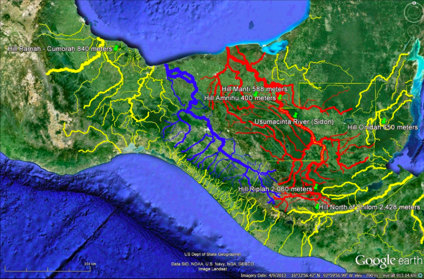
Six Proposed Book of Mormon Hills
I correlate the hill north of Shilom with 2,428 meter Cerro Tuncaj in Baja Verapaz. In this image the semi-opaque white terrain plane is set at an altitude of 2,200 meters. Areas showing through in natural color are higher than 2,200 meters elevation.
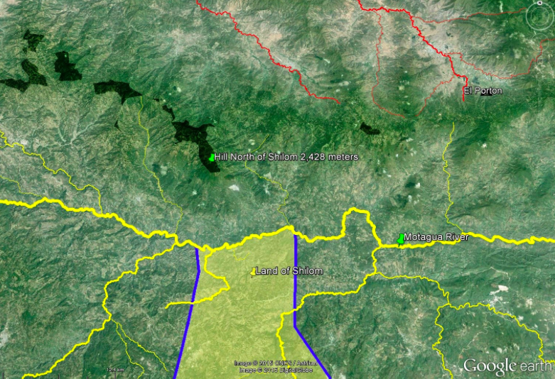
Proposed Hill North of Shilom
Vertical rise from the Motagua = 1,800 meters
Approximate area = 120 square kilometers
Grade = 18% running north from the Motagua to the summit
Following V. Garth Norman, I correlate hill Manti with 588 meter Cerro El Mirador just south of the ruins of Palenque in Chiapas. In this image the terrain plane is set at an altitude of 320 meters.
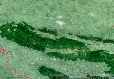
Proposed Hill Manti
Vertical rise from the Chacamax = 420 meters.
Approximate area = 24 square kilometers
Grade = 31% running north from the Chacamax to the summit
I correlate hill Amnihu with 400 meter Sierra del Lacandon just east of Boca del Cerro Canyon in Tabasco. In this image the terrain plane is set at an altitude of 220 meters.

Proposed Hill Amnihu
Vertical rise from the Usumacinta = 380 meters.
Approximate area = 18 square kilometers.
Grade = 22% running northeast from the Usumacinta to the summit
Grade = 39% running northeast from the Usumacinta to the 300 meter contour line
Grade = 72% running east from the Usumacinta in Boca del Cerro Canyon to the 300 meter contour line
For more about the battle that took place on Hill Amnihu ca. 87 B.C. see the blog articles "Gideon" and "Minon."
I correlate hill Onidah with 650 meter Starkey Hill north of the Belize in Cayo. In this image, the terrain plane is set at an altitude of 550 meters.
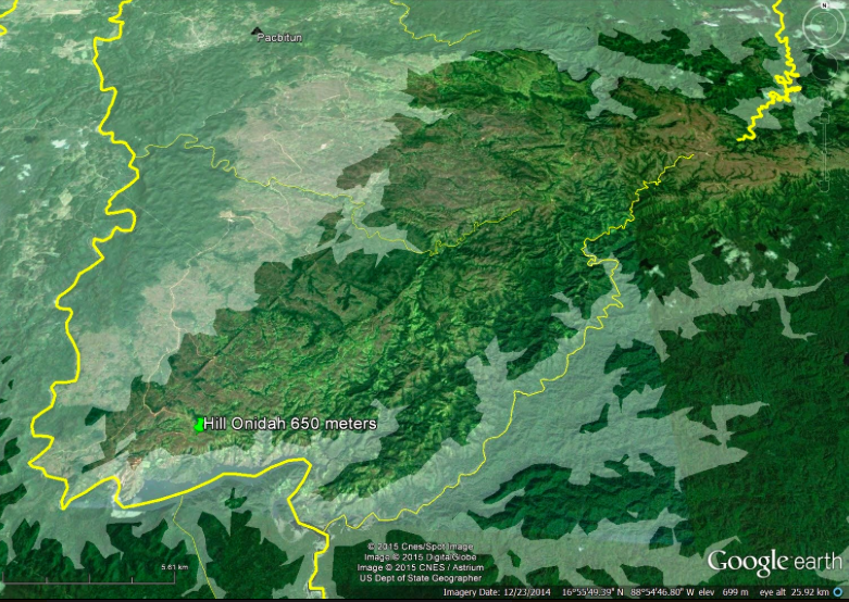
Proposed Hill Onidah
Vertical rise from the Belize = 275 meters.
Approximate area = 140 square kilometers
Grade = 15% running north from the Belize to the summit
Following John L. Sorenson & David A. Palmer, I correlate hill Ramah-Cumorah with 840 meter Cerro El Vigia near Santiago Tuxtla in Veracruz. In this image the terrain plane is set at an altitude of 350 meters.
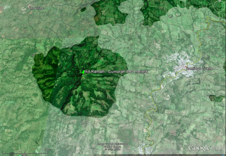
Proposed Hill Ramah-Cumorah
Vertical rise from the Tilapan = 700 meters.
Approximate area = 40 square kilometers
Grade = 20% running west from the Tilapan to the summit
I correlate hill Riplah with 2,060 meter Cerro Pampache in the great bend of the Chixoy in Alta Verapaz. In this image the terrain plane is set at an altitude of 1,560 meters.
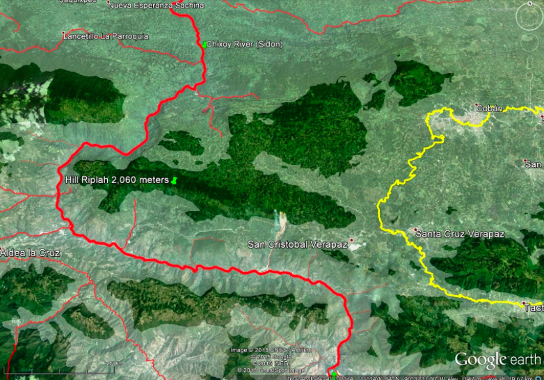
Proposed Hill Riplah
Vertical rise from the Chixoy = 1,670 meters.
Approximate area = 220 square kilometers
Grade = 23% running north from the Chixoy to the summit
Grade = 84% running east from the Chixoy to the 1,500 ,meter contour line
Grade = 81% running southeast from the Chixoy to the 1,500 meter contour line
There are several ways this impressive hill is surpassing, outstanding, massive, strong and abundant compared with its peers:
It has the largest surface area at 220 square kilometers
It has the steepest slopes at more than 80% on its west flank (100% is a 45 degree angle where run = rise)
It has the longest ridge line at 24 kilometers east to west
Cerro Pampache between the Chixoy and the Cahabon is the largest detached hill in highland Guatemala.

Proposed Hill Riplah in Context
The image above has the terrain plane set to 1,500 meters elevation with the white layer at full opacity.
If the etymology described above and my correlations are correct, Riplah is a highly appropriate name for this major upland which is home to one of Guatemala's premiere cloud forests.
To see how I think the Moroni1, Lehi2 and Zerahemnah battle played out around this unique hill, see the blog articles "Manti" and "Captain Moroni in Space and Time."