


An Analysis of the Padilla Gold Plates
By Ray T. Matheny
The Padilla gold "plates" are well known in LDS Church archaeological-anthropological circles, where they have been the subject of publications, papers, discussion, and firsthand examination. They have become an exciting topic and have often been used in missionary endeavors as an example of empirical evidence for the authenticity of the Book of Mormon. If authentic, these twelve postage stamp-size plates represent the moat significant archaeological evidence of the Book of Mormon yet to appear. If not authentic, they are an embarrassing fraud. Thus, they deserve careful examination. The following article will examine the circumstances of their reported discovery, their physical description, their apparent means of production, and the content of their engravings in an attempt to determine their historic value.
The plates were reportedly found in a tomb in Guerrero, Mexico, which was excavated by Dr. Jesus Padilla Orozco and his companions sometime between 1952 and 1956. Dr. Padilla, now a physician in Mexico, claims that many other gold objects were found and distributed among other men participating on the tomb excavation, but he chose to take the plates because the writing on them interested him.
The original Padilla collection consisted of twelve plates, five of which were turned over to Jose Davila, and seven were retained by Dr. Padilla. All twelve plates have now been examined by the author.
Circumstances of Discovery
In January 1971, Dr. Padilla displayed for Dr. Paul Cheesman and me some of the plates and other artifacts reportedly taken from the Guerrero tomb. These consisted of numerous small objects including an array of jade beads shaped like calabashes, short tubes, and round forms, all drilled for stringing. Also found were carved shell, stone receptacles, carved obsidian and jade earspools, jade labrets (ornaments worn on a perforation in the lip), monochrome pottery with cascabel supports (slit-type, bell-like openings), projectile points, miniature pottery vessels, and copper bell - all of which appeared to be of late date for Mesoamerica. Absent from the collection were polychrome-pottery vessels which may have been sold. The assemblage in general is of the Post Classic Period (A.D. 900-1200) and strongly supports Padilla's claim that the material was taken from a tomb in Guerrero. The only objects conspicuously different from those normally found in tombs in the area are the gold plates.
Physical Description of the Plates
General Description of the Plates. The plates are bright gold in color, but the smaller ones in Davila's possession show a sligh t copperish hue when turned to different angles in the light. The plates are of several sizes: .512" x .669" five plates), .787" x .945" (two plates). Five plates consist of small rectangles of gold sheet for which I do not have dimensions. All plates measured are thin, ranging from .011" to .0125" in thickness. More exact notation on individual sizes warrants the careful appraisal that follows. The smaller five plate set has a hinge attached on one edge so that the plates fit together like a bracelet when strung by wire or thread. Each plate has symbols engraved on it, some on one, others on both sides.
Size and Layout of the Plates. The remarkable accuracy of layout and precision manufacture of the pates provides evidence of their date of origin. The plates are laid out as near perfect rectangles. Plate 8 is .5085" and .508" in its width (measured at each end) and .693" and .682" in its length. This is only .0005" difference inn its width and .011" difference in length, which are remarkably small deviations from rectangularity for a handmade item. Table 1 was constructed for five plates (Num. 8-12) to check whether this small deviation was accidental or not.
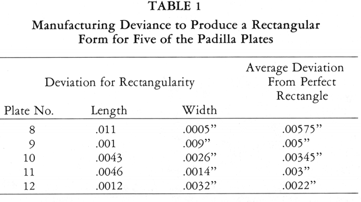
The question of how these gold plates were scribed out and cut is an important one to explore because it will also tell us something about the tools available to the maker. I know of nothing made in antiquity, either in the Old or New Worlds that approaches the rectangularity achieved by the maker of the Padilla Plates.
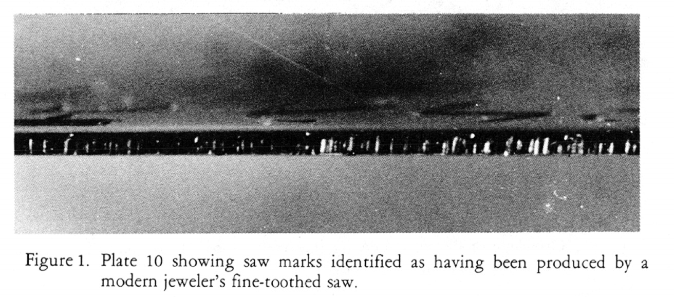
Cutting is necessary to prevent thin sheet metal from being distorted as it is when cut with shears. Sawing leaves a flat surface next to the cut edge. Shears often drag unwanted metal to one edge which must be trimmed off and distorted edges must be hammered flat.
Figure 2
 Plate 9 showing saw marks on one edge which match those found on Plate 10.
This shows that Plate 9 was also cut with a saw. Figure 3 below shows that one edge of Plate 10 was filed to its final dimension, which left groove marks on long lines on the edge.
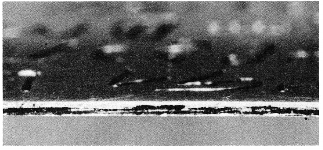 Note file marks running lengthwise on the edge.
Plate Thickness. Plates 8, 9, and 10 constitute a set made up into a bracelet. These plates were measured with a micrometer at five points free from engraving. The comparative results are shown in Table 2. The plates average .0125" in thickness and show an average difference in thickness of .00018". The latter measurement is such a small quantity that to manufacture a set of gold plates by hand methods within these minute tolerances is truly a marvelous achievement.
TABLE 2
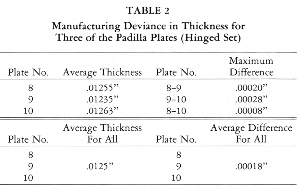
Since the human eye cannot detect such small differences in thickness as those noted for the small plates examined above, one must conclude that a sophisticated measuring device was required to produce a gold sheet in close tolerances.
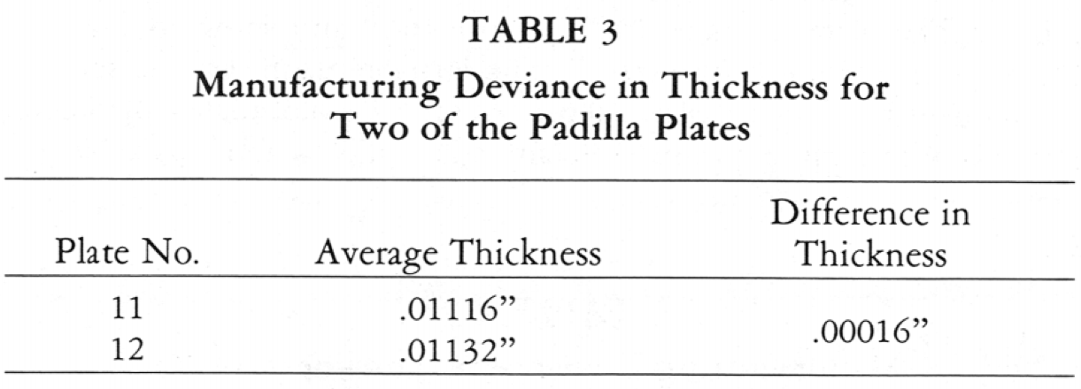
The larger plates were also measured and the results are shown in Table 3. The average thickness for both plates is .01124" and the average difference in thickness between the two is .00016". According to Sr. Jose Davila, Plate 12 was examined by Dr. Daniel C. Worlton about 1962. Davila quotes Worlton as saying, ". . . These gold plates were hammered flat. . . the thickness of the plates varied." In light of my own measurements of Plate 12, I wonder if Worlton examined a different plate than Plate 12.
It should be clear that our sophisticated measurements show we are dealing with gold sheet that has been manufactured by the most precise means known. The plates were cut out of a gold sheet stock that gives every indication of having been manufactured on a metal roller press and not by any known hand method.(The sheet metal roller press was invented by Leonardo da Vinci in the sixteenth century and was not generally used in Europe until the nineteenth century.)
Quantitative Analysis. Plates 11 and 12 have been analyzed quantitatively at Brigham Young University in Provo, Utah, and by Dr. Maurice D. Lambert, of Richland, Washington. Analysis by the atomic absorption method at Brigham Young University showed Plate 11 to be made up of 89% gold, 2% silver, 9% copper, a small amount of zinc and iron, plus traces of other elements. Lambert's testing, using X-ray spectography, shows Plate 12, a probable companion to Plate 11, to be composed of 73% gold, 13% silver, and 14% copper. Only three elements were tested for, and they accounted for 100% of the plate's composition. These methods, then, produced gross results with considerable discrepancy in analysis of the two plates. The assumption that because of the close thickness dimension that both Plates 11 and 12 came from the same gold sheet stock may thus be in error. We must either reject the analyses or assume that two gold sheet stocks of identical thickness were used in the manufacture of Plates 11 and 12.
Despite these discrepancies, the hold in the Padilla Plates is considerably purer than the gold of most New World artifacts. For example, positively identified gold foil from Peru, when checked by the atomic absorption method, showed about 47% gold, 29% silver, 23% copper, and smaller amounts of zinc and iron, plus traces of several other elements. Nonetheless, these analyses do not provide conclusive information at this time, and indicate the need for further quantitative analysis.
Ancient Goldworking in the New World
To place the preceding comments on the shape and composition of the plates in context, it is desirable to review the historical background of Mexican metallurgy. It is well known that metallurgy was practiced in Mexico during Early Classic times (A.D. 200-600) and perhaps earlier. The development of metallurgical techniques in South America is reported recently by Clair C. Patterson to have been a step-wise discovery of techniques going back to 1800 B.C. Specifically, the earliest-known technology for working gold in the New World also comes from South America, at the site of Waywaka, where gold foil and a metalworker's tool kit were found. Joel Grossman reports of this find, "Implications are that the use of metal was already well established in Peru by the initial period." Complicated metal treatments were known in later Peru that equalled the best technology of the Old World craftsmen.
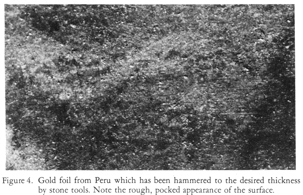
Gold sheet was made by casting various quantities of gold, silver, and copper into ingots which contained numerous impurities, including traces of other elements. The cast ingot was then made into sheet by repeated hammering and annealing. This was the only known process of making thin metal sheets in the New World. Thick sheet metal called plate was cast with ancient technology, but examples of this type are rare. The hammering and annealing process produced a thin but uneven sheet metal marked by numerous pocks (see Figure 4) made by the hammer and anvil. Examination of the Padilla Plates shows no such hammer pockmarks, but only slightly scratched, smooth surfaces.
Script Layout and Engraving
It is the engraving on the plates, however, that gives them their Book of Mormon implications. The Padilla Plates labelled 8-12 have engraved characters on both sides laid out in a consistent symmetry. Five characters can be read across for the width and five for the length, showing twenty-five characters for each side of each plate (see Figure 5). The complex, engraved characters are small, measuring .165" to .084". The smallest character is .027". Such fine engraving probably required the use of a magnifying glass during the engraving process. The engraving technique was analyzed by Don J. Christensen of Las Vegas, Nevada, a professional jeweller and engraver, who asserts that modern methods were used in engraving the

metal plates and in attaching the hinge onto the sheet metal. Christensen notes that the sheet metal is uniform in hardness and thickness, and the attached hinges have been made with modern tubing dies.
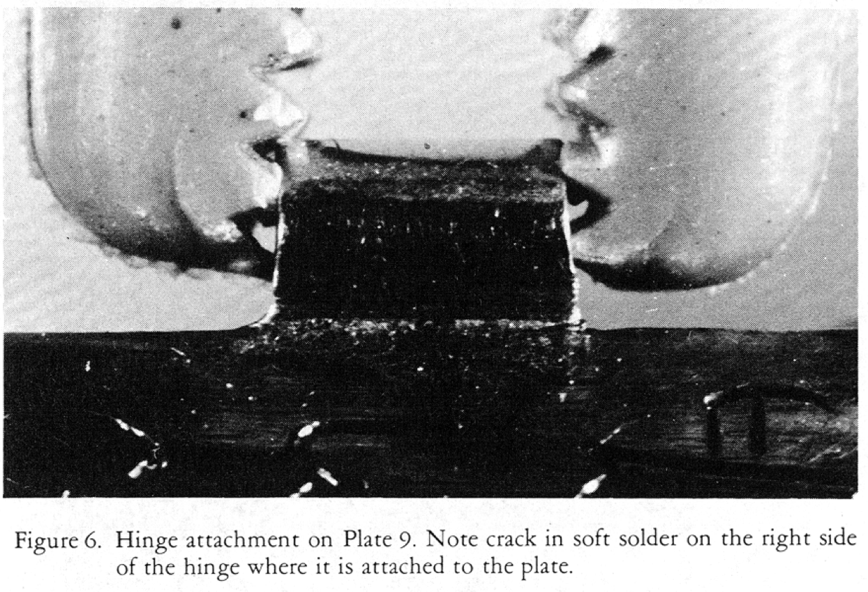
The hinges themselves have been attached to the plates by a soft solder which on Plate ( shows a crack at the point of attachment (see Figure 6). This soft solder can only be a lead base, probably mixed with tin, which melts at around 350° F. No other use of soft solder has been found from pre-Columbian America; only an alloyed type is known. It was made of gold copper, and sometimes silver, which melts at about 1500° F.
Analysis of the Engraven Characters
Art motifs on the plates present a curious mixture of Aztec, Maya, and Anthon transcript likenesses. Plate 3 shows five Anthon transcript-like symbols at the bottom and an anthropomorphic head with scrolls positioned over the characters. The head motif is also found on a gold disk taken from the sacred well at Chichen Itza, Yucatan, Mexico (Figure 13c; Figure 7a). The art style found on the gold disk is rendered in typical Lowland Maya curvilinear design and is in particular noted for the Post Classic Period of the Yucatan Peninsula. The rendering on Padilla Plate 3 is crude in comparison to the disk found at Chichen Itza in that it tends to reduce the aesthetic curvilinearity of the Maya design to more angular lines (Figure 7b).
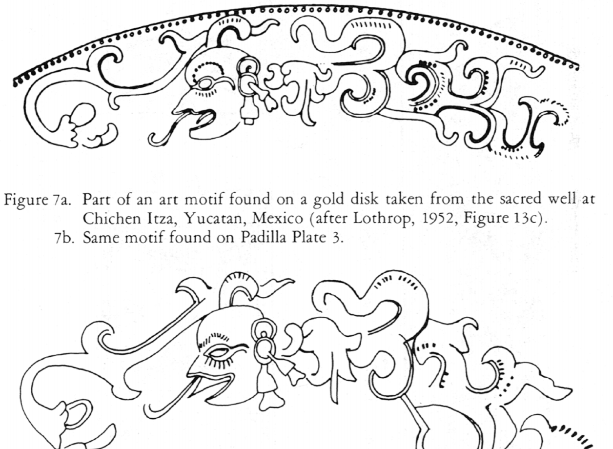
Figure 8a. Part of an art motif found on a wooden lintel at Chichen Itza, Yucatan, Mexico (after Seler, 1915, p. 283).
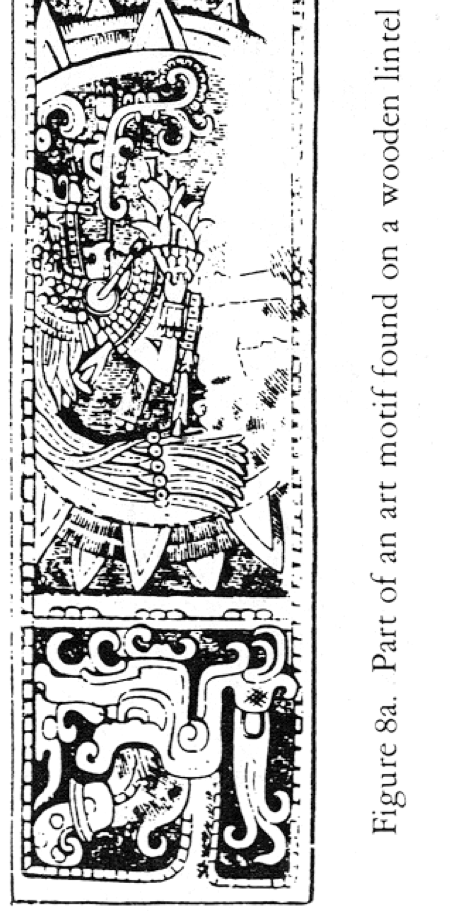
Figure 8b. Same motif found on Padilla Plate 6.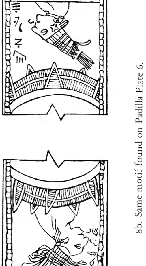
Plate 6 has three panels showing art motifs nearly identical to those found on a carved wooden lintel at Chichen Itza (Figure 8). Again, the design is a crude rendering in comparison to the wooden lintel carving, though the different scale must be considered. This lintel carving, though the different scale must be considered. This lintel is dated to the Post Classic occupation of the Yucatan Peninsula.
Plate 12 shows a tree pictograph that is practically identical to that found on the Aztec Codex Borbonicus, which is dated to the sixteenth century. Other symbols are interspersed with the tree design that are like those found on the Anthon transcript.
The fourth set of symbols are those identified as the Anthon transcript. There is an abundance of these symbols throughout all of the plates and several other symbols not associated with the Anthon transcript, which is a copy of symbols not associated with the Anthon transcript, which is a copy of symbols taken from the Book of Mormon plates by Joseph Smith. Martin Harris then took the transcript to Dr. Charles Anthon and asked him to verify their authenticity. The correspondences of the inscriptions on the Padilla Plates to those of the Anthon transcript are remarkable and those correspondences deserve very close analysis.
In checking on a possible source for the Anthon symbols, I was told by Dr. Gareth W. Lowe, field director of the New World Archaeological Foundation, that the Mexican Mission had used a tract in the early 1960s entitled El Libro de Mormon: La Historia de las Americas Antes de Colon (Salt Lake City: Deseret News Press, n.d.). In this tract (.5; Figure 9a), the top four lines of the Anthon transcript were reproduced by an artist's drawing (not a photocopy of the original). The bottom three lines of the transcript were not reproduced in the tract.
Checking the possibility that someone had copied these top four lines as a base for the symbols used in the Padilla Plates, I broke down the entire set of Anthon symbols into basic elements occurring singly and in compounds (see Figure 10), using the Crowley numbering system (see Figure 11).
The single elements did not need to be repeated to qualify. Symbols that appear to be similar to one another are listed as variants.
Facsimile de los caracteres copiados de las planchas del Libro de Mormon por el Profeta.
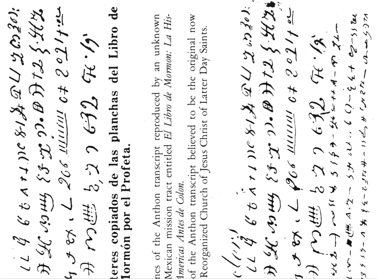
 Figure 9a. Top four lines of the Anthon transcript reproduced by an unknown artist for a Mexican mission tract entitled El Libro De Mormon: La Historia de las Americas Antes de Colon.
9b. Photocopy of the Anthon transcript believed to be the original now held by the Reorganized Church of Jesus Christ of Latter Day Saints.
For example, Crowley number 4 () is regarded as the same as number 39 ( ), but in reality these may have been separate morphemes.
Compounds were regarded as assemblages of elements which may be made up of infixes and/or affixes appended to a basic element. An example of the use of an infix may be found by referring to the Crowley Num. 100 and 104, which show the use of ( ) as a basic element without appendages, but then seeing it used as part of a compound infix in Num. 3, 7, and 31, and in others. An example of an affix may be found in Crowley number 4, where the symbol ( ) is appended by the affixes ( ) making a complete assemblage of ( ), but no element crosscuts another.
Following these simple rules allows us to make a reasonable breakdown of the Anthon transcript and to see at least the limited number of symbols used singly and in combination. This was not an attempt to make a linguistic analysis of the Anthon transcript--I leave this to epigraphers--but it is a useful device to isolate all possible components of symbols available to anyone wishing to reproduce it. Further, no claim is made that the element breakdown is complete; it was made as a mattedr of convenience for this study.
Using this method, ninety-five elements and compounds were discerned which were used as symbols having some presumed meaning. Of these, thirty-six are single-occurring elements, many of which also appear as parts of compound symbols. Sixty-two are compounds consisting of elements noted above. There are several instances where some of the elements of the compound appear only on one compound symbol and not singly. For example, Crowley number 201, consisting of elements ( ) and ( ), can be considered to make up a compound ( ). As it is only a sample of one or more of the writing systems (probably taken from a single text) found on the gold plates from which Joseph Smith translated, we would expect the Anthon transcript to be an incomplete set of symbols, which is what we think to be the case.
Method of comparison of the Anthon symbols with those of the Padilla Plates was to use the above-described element and compound list placed in vertical columns (Figure 10) with the symbols that appear an each numbered plate shown to the right in respective columns. Autograph copies of each plate in an enlarged form were used against the symbol list of the Anthon transcript looking either for single elements that stood alone or for compounds. A total of thirty-eight Anthon transcript-like symbols appear on the Padilla Plates. Of these, twenty-three are compounds, and fifteen are single symbols, recognizably the same or greatly similar to the transcript rendered by Joseph Smith. Several of the compound symbols are complex assemblages of up to ten parts which would seem to rule out accidental duplication.
How do we account for the fact that so large a number of the Anthon transcript symbols appear on the Padilla Plates in almost identical style? Recall the Mexican missionary tract that has the top four lines of the Anthon transcript reproduced by and artist An analysis of these four lines of symbols and those found on the Padilla Plates reveals a curious fact: 66% occur on the plates. An analysis of symbols found on the bottom three lines of the Anthon transcript shows that of those symbols that were not already displayed in the top four lines of the missionary tract, only three (.031%--one only in part) are found on the Padilla Plates. Forty that do not appear in the top four lines do not appear on the Padilla Plates. If even one complicated compound symbol from the bottom three lines of the Anthon transcript appeared on the Padilla Plates, one would be forced to consider some source other than the missionary tract, but since the only symbols that can be correlated are a simple dash, a dot, and one zig-zag line (Element number 64), then we must look at these as being purely accidental correspondences.
Conclusions
Since Dr. Padilla has provided testimony concerning when, how, and where the plates were found, and has maintained over the past thirteen years that this story is true, the plates were investigated from the point of view that they were genuine. Each question that was generated about the technology of the plates during the investigation was treated in such a way as to discover the nature of the tools and techniques of their manufacture.
Layout and cutting of the plates were remarkably accurate, to say the least. A flat surface, perpendicular reference, and precision measuring devices were required. In addition, the plates were cut by a fine-toothed saw, a type commonly employed by jewelers today.
These instruments were not available to ancient American metallurgists and were available to Old World craftsmen only in relatively recent times. The production of gold alloy sheet with the close tolerances of thickness of the Padilla Plates is most certainly a modern achievement. The production of gold alloy sheet with the close tolerances of thickness of the Padilla Plates is most certainly a modern achievement. The method of engraving is also a modern one, requiring finely-made, hardened steel tools. The making of cylindrical hinges in such perfect symmetry is also astonishing as is the fact that they were soldered by technique known only in recent times.
The copied art motifs from the wooden lintel located at Chichen Itza and from the gold disk taken from the sacred well of the same archaeological site are clumsy attempts to portray authenticity. It is highly unlikely that these motifs, being individual works of art, should be duplicated in another medium by another culture at another location at another time. Further, the copying of the Aztec symbol from the Codex Borbonicus was an act of little ingenuity. It is difficult to imagine a written medium shoeing writing symbols used from the Book of Mormon period, which closed at A.D. 421, according to Pratt's chronology, mixed with symbols used over 1,000 years later by the Aztecs, and yet another of the Classic Maya period.
The script used for the plates clearly was in part copied from the Mexican missionary tract which supplied a large percentage of the total number of symbols used. Not only was the artist apparently unaware that the bottom three lines of the Anthon transcript were not printed on the Mexican tract, but he also failed to understand the clustering of symbols that occurs in any language in his indiscriminate distribution of the Anthon figures. Additionally we must consider that the Anthon transcript was written with a quill pen or equivalent. This is evident in the fact that the symbols begin with a thin line, then widen on the curvilinear strokes. Thus, when we see the Anthon transcript duplicated on metal or other media with the same curvilinear strokes, we suspect that it is a copy from the pen and ink rendition, without a change in artistic style. Such a rendition in itself constitutes grounds for rejection.
It is my opinion that the Padilla Plates are not authentic because of any one of the major technological anachronisms given above. But given all of the factors considered, the case against the authenticity of the Padilla Plates should be closed once and for all.
Paper presented at the Twenty-Fourth Annual Symposium on the Archaeology of the Scriptures, Brigham Young University, October 1974.
Ray T. Matheny is professor of archaeology and anthropology at Brigham Young University.
Metallurgists classify sheet as being under 1/8 inch inch in thickness and palte as being over 1/8 inch; therefore, the Padilla "plates" should be referred to as sheets of gold stock since they are about 1/20 as thick as plate.
M. Wells Jakeman and Ray T. Matheny, "Gold Plates from Mexico," Newsletter and Proceedings of the SEHA, Number 78.7 (January 1961); see also the following unpublished manuscripts: Jose O. Davila, "A Study of the Amuzgus Gold Plates," 31 July 1963; Paul R. Cheesman, "A Report on the gold Plates Found in Mexico," 1971; Paul R. Cheesman, Ray T. Matheny, and Bruce Louthan, "A Report on the Gold Plates Found in Mexico," 1973, all in the possession of Paul R. Cheesman, BYU Religion Department.
In a letter to Paul R. Cheesman, 26 June 1971, Dr. Padilla stated that the tomb was located and emptied of its contents between 1952 and 1956 by himself and several friends. He declined to give the location of hte site, but subsequently informed Dr. Cheesman that it was in the state of Guerrero.
Jose Octavio Davila Morales obtained five small, hinged plates from Dr. Padilla in about 1961. His report (see fn. 2) states that Padilla dug at the site of Piedra del Rey, near the village of Amuzgus, Oaxaca, in 1957. Davila was unaware when he received the plates that seven other inscribed plates existed.
To illustrate how small the variances are, I measured head hair samples from three European-descent individuals and found the maximum difference was .0006" or three times the thickness difference measured on plates 8, 9, and 10.
See Davila, "A Study of the Amuzgus Gold Plates." Hand-hammered gold sheet is necessarily of unequal thickness because of the method used in making it, and it does have a rough surface. Dr. Worlton either did not examine Plate 12 very closely, did not use a micrometer, or examined a crude duplicate of the plate that I have examined.
It is not likely that different stocks could be found of identical thickness. Even modern manufacturing tolerances allow some variation between runs of production sheet.
The following locations and chronological scheme apply: Lowland Maya country, consisting of the Yucatan Peninsula; Gulf Coast region including the Mexican states of Campeche, Tabasco, Chiapas, and Veracruz; the Peten of Guatamala, British Honduras, and parts of Honduras. The Maya cultures of the past have been divided into the following chronological scheme:
|
Pre Classic Maya: Befor the time of Christ Proto Classic: 100 B.C.-A.D. 200 Early Classic: A.D. 200-600 Late Classic: 600-900 Post Classic: 900-1200 Proto Historic: 1200-1500 |
John L. Sorenson, "Reconsideration of Early Metal in Mesoamerica," unpublished manuscript, 1972, in the possession of Sorenson, BYU General Education Department.
Clair C. Patterson, "The Development of Arsenic-Copper Alloys in Peru During Middle Horizon Times," paper delivered to the Society for American Archaeology, 37th Annual Meeting, May 1972. Patterson presents evidence for the development of metallurgy in Peru in stages between 1800 B.C. and A.D. 1500. She says the Peruvians did not discover the principle of the bellows, sulfide smelting, or silver cupolation.
Joel Grossman, "The Beginnings of Metallurgy in South-Central Highlands of Peru." Paper delivered to the Society for American Archaeology, 37th Annual Meeting, May 1972. The "Initial Period" is presumed to mean food production economy ca3000 B.C.
Heather N. Lechtman, "Ancient Methods of Gilding Silver: Examples from the Old and the New Worlds," in Science and Archaeology, ed. Robert H. Brill (Cambridge, Mass.: MIT Press, 1971); and "The Gilding of Metals in Precolumbian Peru," in Application of Science in Examination of Art, ed. William J. Young (Boston: Museum of Fine Arts, 1973).
Don J. Christensen (of M. J. Christensen & Sons Jewelers, Las Vegas, Nevada) to Ray T. Matheny: "We have examined the small gold and silver alloyed plate you have numbered S-3. In our opinion, this is of fairly recent manufacture. They would have been rolled out on fairly modern (present century) rollers to obtain the uniform thickness and hardness. Also, the attached partial hinge is a tube of recent tubing dies. The engraving is done by hand using steel engraving tools. This type of work could be done by anyone who is familiar wit hand engraving at this time. It is my belief and understanding that ancient engraving was done by the method we presently call chasing, that is by using a tool and a mallet to propel the tool in cutting the characters. The engraving in question was not produced in this manner. The edges of the plate appear to have been cut with a modern jeweler's saw. There are what appear to be saw or file marks on some of the edges. The thickness of the plate is .3 mm. this is a standard thickness in modern supply. It is my opinion based on the above evidence that the plate is a modern one made to look old and is not of ancient origin.
Cylindrical hinges in near perfect symmetry, made in such small size, could have been formed by a hard metal die and mandrel. It is inconceivable that a metalsmith could have rolled gold sheet to such symmetry as is represented here by the tools available in pre-Columbian times.
D.T. Easby, Jr., "Ancient American Goldsmiths," Natural History 65 (October 1956):401-09.
Samuel K. Lothrop, "Metals from the Cenote of Scrifice: Chichen Itza, Yucatan," Memoirs of the Peabody Museum, Harvard University 10:2 (1952).
Lothrop calls this particular design a Maya one with the exception of the small hatched lines which he shows to be a Toltec characteristic. See Lothrop, "Metals from the Cenote of Scrifice," p. 32.
Edward Seler, Gesamnelte Abhandlunger 5 (Graz, Austria: Akademische ruck. Verlarsanstalt, 1961), p. 283.
Ariel L. Crowley, About the Book of Mormon (Salt Lake City: Deseret News Press, 1961). Crowley's fine work is well known, hence the use of his numbered characters. It should be noted that Num. 97, 98, and 99 are missing from Crowley's system. Also, there is osme disagreement on the total number of separately rendered characters; for instance, Crowley Num. 136 and 137 would be a single symbol to me (compare the photocopy of the Anthon transcript, Figure 9b).
Autograph copies of the symbols found on each plate were made b William Adams, Jr., a scholar of Semitic languages.
Dean C. Jessee has identified the handwriting of the Anthon transcript as that of Joseph Smith, Jr.; however, this has been challenged.
William Adams, Jr., "Cryptographic Analysis of the Padilla Plates," unpublished manuscript, March 1973. Adams' comments on the Padilla Plates suggest that the artist of the plates seems to have gotten mixed up in the directions the symbols should appear. Some symbols, and clusterings of symbols, are rendered backwards. Ms. in the possession of Paul R. Chessman, BYU Religion Department.