


Usumacinta River is the River Sidon
by Joe V. Andersen
December, 2011
Materials, concepts, maps or conclusions presented at our forums or appearing on this website or
emailed to BMAF members and guests is the sole responsibility of the contribiuting author(s) and does
not necessarily imply that members of the Board of Directors or members of BMAF agree with all or
any part of the subject matter and is not sponsored in any way by the Church of Jesus Christ of Latter-day Saints
When we apply precisely what the Book of Mormon states by geographically identifying the land and city of Nephi, then we can identify which river was the river Sidon. In other words, if Kaminaljuyu was not the city of Nephi and if the Salama Valley was Nephi then the Usumacinta River, including its tributaries, would be the river Sidon.
BUILDING AN INTERNAL MAP FROM THE BOOK OF MORMON
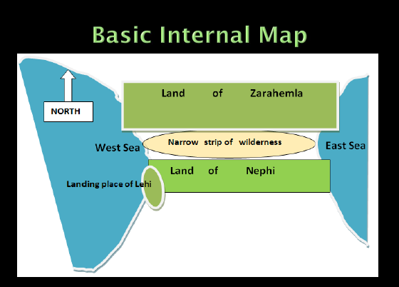
Alma 22:28 tells us that Lehi landed on the west side of the land of Nephi, “…on the west in the land of Nephi, in the place of their fathers’ first inheritance, and thus bordering along by the seashore.” Then he explains where the land of Nephi was located, “…bordering even to the sea on the east and on the west and which was divided from the land of Zarahemla by a narrow strip of [mountainous] wilderness, which [wilderness] ran from the sea east even to the sea west…and thus were the Lamanites and the Nephites divided.”
Helaman 50:11 explains the purpose of the narrow strip of wilderness, “…Moroni cut off all the strongholds of the Lamanites in the east [sea] wilderness, yea, and also on the west [sea wilderness], fortifying the line between the Nephites and the Lamanites, between the land of Zarahemla and the land of Nephi, from the west sea, running by the head of the river Sidon.”
Alma 50:8 emphasizes the direction and distance of the narrow strip of wilderness, “And the land of Nephi did run in a straight course from the east sea to the west [sea].” Moroni established and maintained this narrow strip of wilderness as a military defensive line beginning about 72 BC. The Book of Mormon identifies where the cities of Zarahemla, Manti, and Nephi, were located relative to the east and west seas, to each other, to the narrow strip of wilderness, and relative to the river Sidon.
ZARAHEMLA:
|
Zarahemla was the “capital city” and near the “capital parts of the land” (Helaman 1:27). It was also located north from and yet “by” or near the narrow strip of mountainous wilderness (Alma 22:27). It was in “the heart of our country (Alma 60:19). This indicates that it was in the middle of the land of Zarahemla and not very far from the narrow strip of wilderness. Mormon tells us in the first chapter of Helaman that Zarahemla was located in “the center of the land.” He repeats the term “center of the land” in verses 24, 25, 26 and 27. Helaman 1:27 states that the Lamanites“… had come into the center of the land, and had taken the capital city which was the city of Zarahemla…” Since the land of Zarahemla extended from the east sea to the west sea then the city of Zarahemla must have been located in the center of the land about midway between the east sea and the west sea. * For information illustrating that the narrow strip of wilderness was mountainous please refer to several articles located at the BMAF website including my article entitled FootPrint of Zarahemla, Article two (www.bmaf.org/articles/footprints_zarahemla_two__anderson). |
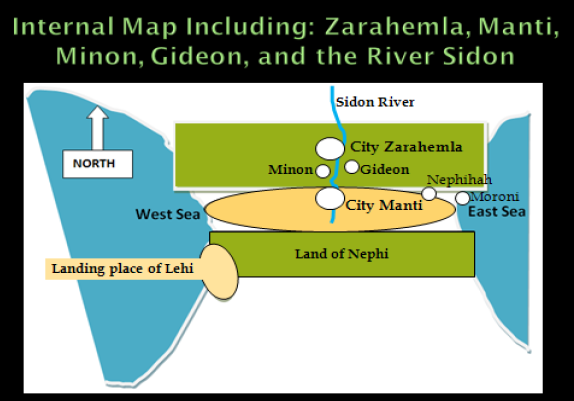
THE RIVER SIDON:
| Alma 2:15 & 34 states that Zarahemla was located on the west side of the river Sidon. River Sidon flowed northward from the narrow strip of wilderness. Since the river Sidon was located east of Zarahemla and Zarahemla was located in the center of the land, then the river Sidon was also located in the center of the land or perhaps it was located east of center. According to the Book of Mormon the river Sidon was certainly not located west of the center of the land of Zarahemla. |
MINON AND GIDEON:
| Following the Sidon southward from Zarahemla, not more than a couple of miles, was a crossing of the river Sidon where the Amlicites pinned Alma in the river near the west bank (Alma 2:26-34). Minon and Gideon were each located less than a half day’s march southward from this crossing (about 12 miles). Minon was located on the west of Sidon and Gideon was located on the east of Sidon. The distance between Minon and Gideon could not have been more than half a night’s march by a tired Amlicite army (about 6 or 7 miles) (Alma 2:20-27). Minon was located up and south from Zarahemla in the path to Nephi“…in the land of Minon, above the land [city] of Zarahemla, in the course of the land [city] of Nephi… (Alma 2:24).” Gideon, like Minon, was located up in elevation from Zarahemla. Gideon was located southeastward from Zarahemla because it was located on the east side of river Sidon (Alma 62:7). |
MANTI:
| Manti, located on the west side of Sidon, was therefore located southwestward from Gideon, “…Alma was journeying from the land of Gideon southward, away to the land of Manti,…he met with the sons of Mosiah journeying towards the land of Zarahemla [from Manti area] (Alma 17:1).” This confirms that Manti was located almost directly south of Minon and Zarahemla. It also indicates that Zarahemla was not a great distance from Manti. Alma 56:24 -25 states, “…Neither durst they march down against the city of Zarahemla…” The fact that the Lamanites contemplated attacking Zarahemla from Manti confirms that Zarahemla was located within striking distance from Manti. Since Manti was located in the narrow strip of wilderness and “by” or near Zarahemla and since Zarahemla, Minon, Gideon and the river Sidon were all located in the center of the land, then Manti also must have resided about midway between the east and west seas. |
THE HEADWATERS OF SIDON:
| The headwaters of Sidon were located higher in elevation from Manti and in the south part of the narrow strip of wilderness but near Manti (Alma 56:25 and 43:22 & 27:22-26 & Alma 16:6-7). Therefore, Manti and the headwaters of Sidon must have been located, if not closer to the east sea, then at least about midway between the east and west seas. This conclusion is confirmed because Alma stated, “…neither durst they cross the head of Sidon, over to the city of Nephihah.” Nephihah was located near Moroni, which was located on the east sea. This scripture also indicates that Manti was about the same distance from Zarahemla as it was from Nephihah. Both Nephihah and Zarahemla were located fairly close to Manti because they were both potential military targets for the Lamanites, who resided at that time in Manti. |
CITY OF NEPHI:
|
Now for the more critical question: Where was the city of Nephi located?
Nephi was located in the center of the land of Nephi between the east and west seas and very close to the narrow strip of wilderness as shown on the following map and corroborated hereafter. The Book of Mormon indicates that the city of Nephi was located so close to the narrow strip of wilderness that the people could see it from Nephi and Shilom. The hill north of Shilom was in the foothills of the wilderness and it was located two or three miles from Shilom. The hill north of Shilom is discussed three times in the Book of Mormon. Nephi was located within a mile or two southerly from Shilom (Mosiah 9:14-15). Shemlon was located not more than a couple of miles eastward from Nephi and Shilom. |
You may ask, “How can you possibly get that information out of the Book of Mormon?” This is a very good question that I will now address.

There are three accounts in the Book of Mormon about the hill north of Shilom which will help us better understand how close the cities of Nephi, Shilom, and Shemlon were to each other and thus to the hill north of Shilom and to the narrow strip of wilderness:
(1.) King Mosiah I gathers his followers on the hill north of Shilom when he flees Nephi.
After the Nephites had lived in the land of Nephi for about 370 years, King Mosiah I (about 210 BC) obeyed the Lord and fled from Nephi to Zarahemla. Omni and Mosiah state the following: Omni 1:13,
| “…He [Mosiah] did according as the Lord had commanded him. And they departed out of the land [of Nephi] into the wilderness,…[Mosiah11:13 (up to)] the hill north of the land of Shilom, which had been a place of resort for the children of Nephi at the time they fled out of the land…” [then Omni 1:13 continues] “…through the wilderness until they came down into the land which is called the land [or city] of Zarahemla.”“…He [Mosiah] did according as the Lord had commanded him. And they departed out of the land [of Nephi] into the wilderness,…[Mosiah 11:13 (up to)] the hill north of the land of Shilom, which had been a place of resort for the children of Nephi at the time they fled out of the land…” [then Omni 1:13 continues] “…through the wilderness until they came down into the land which is called the land [or city] of Zarahemla.” |
The following is a cross-section illustration of what these scriptures state:

|
This hill north of Shilom was a gathering “place of resort” for Mosiah I to assemble “all those who would hearken unto the voice of the Lord.” How many were there? Perhaps 5 to 20 thousand, it is unclear. The important point is that the hill north of Shilom was located at the very southern edge of the narrow strip of wilderness, according to these scriptures. It must have been an area large enough, and with sufficient water, where several thousand people fleeing from Nephi, Shilom, and the surrounding area could have gathered and lived, for at least a few days, before traveling from there through the wilderness and then down to Zarahemla. It was not a small hill and it was a defensible “place of resort” for the fleeing Nephites.
|
2. King Noah built a temple tower and a great tower on the hill north of Shilom.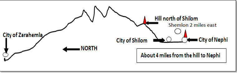
Mosiah 9:6-8, quoting Zeniff, states that the king of the Lamanites:
|
“…covenanted with me that I might possess the land of Lehi-Nephi, and the land of Shilom. He also commanded that his people should depart out of the land [cities], and I and my people went into the land [cities]…and we began to build buildings and to repair the walls of the city, yea, even the walls of the city of Lehi-Nephi, and the city of Shilom.”
Remember that there must have been defensive walls around the city of Nephi and the city of Shilom and that the Lamanites had not maintained the walls of Nephi and Shilom. Note also that there is no requirement for defensive walls around the Lamanite capital at Shemlon. |
Mosiah 11:1-13 states:
|
“…Noah … built a tower near the temple; yea, he could stand upon the top thereof and overlook the land of Shilom and also the land of Shemlon, which was possessed by the Lamanites and he could even look over all the land round about…and he caused a great tower to be built on the hill north of the land of Shilom.”
All these areas must have been within a few of miles of each other, including the hill north of Shilom, because they were all visible from Nephi. And remember that King Noah could even see the Lamanite soldiers coming from Shemlon from his tower near the temple. Without binoculars one cannot see people farther than 2 miles. King Limhi could see the Lamanite preparations for war at Shemlon from the temple tower (Mosiah 20:8). |
3. Ammon and his 15 scouts used the hill north of Shilom as their base to observe Shilom and Nephi.
|
|
About 121 BC Ammon and 15 others were sent by Mosiah II to inquire about Zeniff and his followers. Remember over 60 to 70 years had passed without communication between Zarahemla and Nephi. Mosiah 11:4-7 states:
|
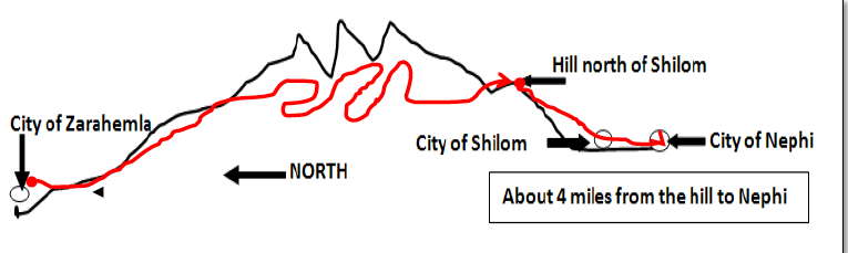
The City of Nephi was located just southward from Shilom about a mile or so (Mosiah 9:14-15). The hill north of Shilom was located not more than 2 or 3 miles from Shilom because Ammon could see Shilom and Nephi from the hill. This was a prominent hill and one that was located at the very southern edge of the narrow strip of mountainous wilderness.
Since all of these locations and cities were located within several miles of each other, then the city of Nephi must have been located about midway between the east and west seas and directly south of the cities or locations of Zarahemla, Minon, and Manti. Then the city of Nephi must have been located about midway between the east and west seas and directly south of the cities or locations of Zarahemla, Minon, and Manti.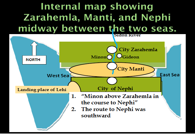
Let us now look at a couple of Google maps of the area to see how this internal map fits into the geography of Mesoamerica.
First, is a satellite view showing where the collision of the North American Tectonic Plate with the Caribbean Plate formed the Cuchumatanes and Santa Cruz chain of mountains extending from the Pacific to the Gulf of Honduras. This resulted in the Chixoy Fault Line depicted in red.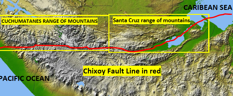
This is the only geologic formation in all the Americas that forms a chain of mountains that runs from east to west, from sea to sea, that is narrow and rugged, and that could have been a viable defensive line that Moroni could have used to protect the Nephites on the north from the Lamanites on the south. The area just south of where the two mountains meet is the only area where there is a reasonable passage way through this chain of mountains to Coban and then to the interior of Guatemala.
V. Garth Norman, F. Richard Hauck, Joseph L. and Blake Allen, and many others believe this Cuchumatanes/Santa Cruz chain of mountains to be the narrow strip of mountainous wilderness identified in the Book of Mormon. It is the most identifiable geographical feature mentioned in the Book of Mormon.
The following will be the application of the internal map to the Google geographical map.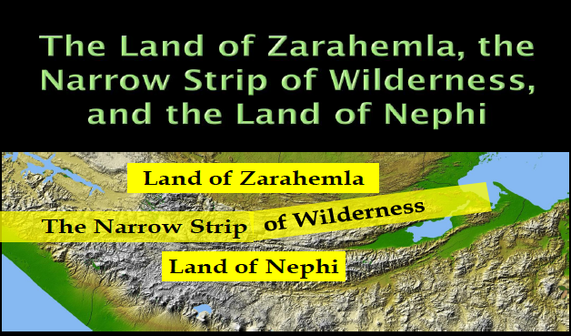
Now let’s add the proposed locations of the cities of Zarahemla, Minon, Gideon and Manti according to the second internal map. Also on this map are the Grijalva River (green), the Usumacinta River (light blue), and a tributary to the Usumacinta, the Icbolay River (dark blue).
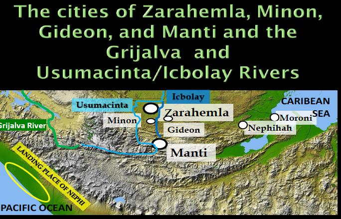
Now let’s add the city of Nephi/Salama midway between the east and west seas, just south of the narrow strip of wilderness, and southerly from Zarahemla and Manti as required by the Book of Mormon. Shown in green is the Grijalva model for the locations of Kaminaljuyu/Nephi and Zarahemla/Santa Rosa neither of which is located midway between the east and west seas.
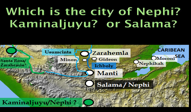
1. Salama/Nephi located just south of the narrow strip of wilderness (white circle).
2. Kaminaljuyu/Nephi located within the city of Guatemala (green circle).
Kaminaljuyu is located about 40 air miles south of Salama and about 165 air miles southeast from Santa Rosa.
COMPARING KAMINALJUYU WITH SALAMA VALLEY
Based upon previous discussions in this article I have established the following six critical questions substantiated by Book of Mormon references which will allow a comparison between Kaminaljuyu and Salama.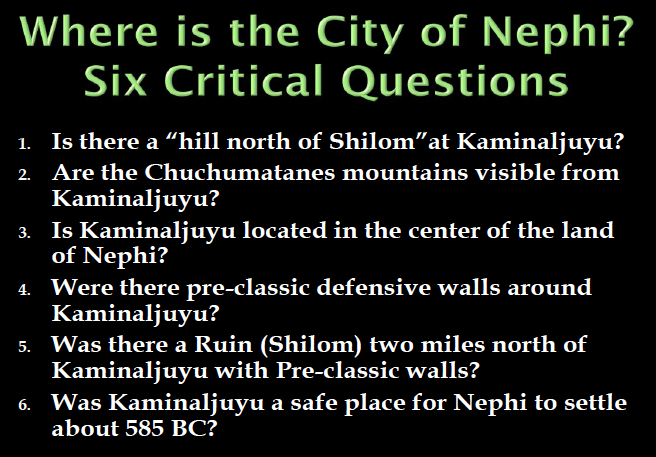
KAMINALJUYU
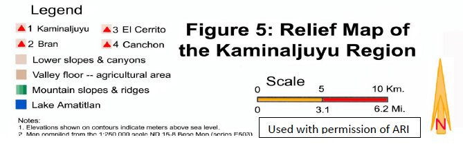
The first is a topographical relief map showing the Kaminaljuyu plateau (5000 ft.in elevation) in brown. The light color shows the ravines and areas below 5,000ft. The green area shows the mountains to the west and southeast, however, to the north there is not even a small hill that rises above the elevation of about 5,150 ft. at Kaminaljuyu.
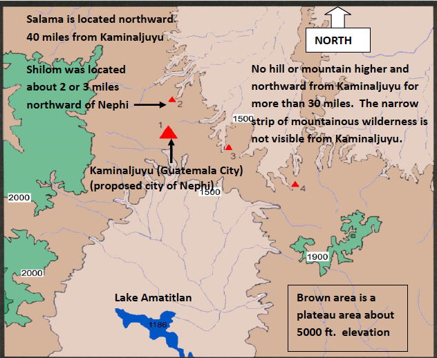
Next is a cross-section of the actual elevations from the Pacific coast northward through Kaminaljuyu, then northward through the Salama valley, then through the Santa Cruz Mountains, and then down to the Usumacinta River. Notice on the high plateau where Kaminaljuyu is located there are no hills higher than the plateau northward from Kaminaljuyu (Guatemala City).
No hill or mountain higher and northward from Kaminaljuyu for more than 30 miles. The narrow strip of mountainous wilderness is not visible from Kaminaljuyu until one comes to the Chuacus mountain range some 30 miles away. (Used with permission of ARI)
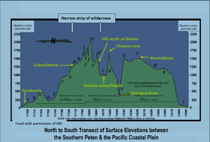
| The 6000-ft Chuacus Mountain prohibits one from seeing the narrow strip of mountainous wilderness from Kaminaljuyu. The distance of about 50 or more air miles from Kaminaljuyu also limits the visibility of this range of mountains. |
3. Is Kaminaljuyu located about midway between the east and west seas? No.
4. Did Kaminaljuyu have Preclassic defensive walls around it? (Mosiah 9:6-8)? No.
Kaminaljuyu was the dominant culture and had no need to have defensive walls. From about 1500 BC this community was in the process of expanding its borders, taking prisoners, and enslaving or killing the conquered leaders. (AuthenticMaya.com)
5. Was there a late Preclassic ruin (Shilom) about one mile or so north from Kaminaljuyu that had defensive walls around it (Mosiah 9:6-8 &7:3-15)? No.
There is no evidence of a late Preclassic ruin or city of Shilom located about 2 miles north of Kaminaljuyu containing evidence of a defensive wall around it.
6. Was Kaminaljuyu a safe place for Nephi to have taken his family about 585 BC? No.
The heavy population of Kaminaljuyu (about 30,000 by about 585 BC) precluded it from being the city of Nephi.
Let’s expand on the answer to question number 6.
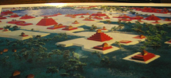
(a). What did Kaminaljuyu look like when Nephi landed about the year 588 BC?
This artist's illustration below shows what the beautiful city of Kaminaljuyu probably looked like about the time Lehi landed in the Promised Land. More than 30,000 people inhabited the area at the time.
 |
| Kaminaljuyu is located about 60 miles from the Pacific and about 140 Miles from The Gulf of Honduras. |
Settlement at Kaminaljuyu started about 1500 BC. By about 750 BC the Lake Miraflores had been developed, and temples were being built around it. It had an extensive irrigation system and farm lands in place. It was constantly expanding its borders, sacrificing the conquered leaders and using slaves to build their large adobe-type structures. By about 580 BC Kaminaljuyu had become one of the largest Preclassic city/states in Central America with only El Mirador and the Olmec heartland larger in size (AuthenticMaya.com).
Can you imagine Nephi walking into Kaminaljuyu with his 4 men 5 women and about 15 children under the age of 12 (1 Nephi 5:6), taking over Kaminaljuyu, becoming “King of Nephi” (Jacob 1:15), and building a temple after the manner of Solomon’s Temple (1Nephi 5:15)? No. This scenario would not have been feasible. He did not have the manpower or capacity to conquer the city/state of Kaminaljuyu and become king. It would not have been a safe place for Nephi and his family to settle.
(b) How Many People Were Living Within Various Cultures Along the Pacific Corridor at The Time Lehi Landed?
| It is now without controversy that at the time Lehi landed there were extensive civilizations or cultures existing in many areas in Mesoamerica wherein hundreds of thousands, and more likely millions, of people resided. |
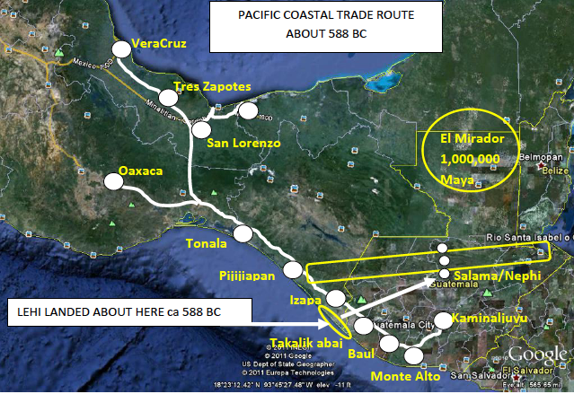
This Preclassic Pacific Coastal Trade Route (above) went approximately as follows (ca 588 BC):
|
From the Kaminaljuyú area, with its population of about 30,000 people;
Down to the Pacific coast to Monte Alto, with its population of several thousand; Northward inland following the coast to El Baúl, with its several thousand; Northward to Takalik Abaj with its many thousands; Northward to the Izapa area with its many thousands (Lehi landed near this area); Then to other cities along the Pacific coast to the Isthmus of Tehuantepec; Then to the many large cities in the Olmec heartland and surrounding areas including Oaxaca, La Venta, Tres Zapotes, and San Lorenzo among many others with their perhaps several million. |
There were just too many people in Kaminaljuyu and along the Pacific coast and in the Isthmus of Tehuantepec for Nephi to have safely located his small colony of 20 to 30 people in any of those locations.
Since the answer to each of the above questions is “no,” then it should be concluded that Kaminaljuyu could not have been the city of Nephi, and the Grijalva River would not have been the river Sidon.
What a difficult problem Nephi was faced with when he landed on the Pacific coast about 588 BC. I believe he quickly realized that he had to take his people to an area where he could protect them; to an area that was isolated from so many cultural and religious distractions. Had he gone to Kaminaljuyu they would have either killed the Nephites or made them assimilate thus losing their culture and religion. As General Authority Emeritus, Guatemala City Temple President and Mesoamericanist Clayton Mask told me a couple of weeks ago, “That would have been like Brigham Young telling the Saints to move on to San Francisco to build up the Kingdom.”
I submit that Nephi, like Brigham Young, went inland to a safer location. I believe that Nephi went into the wilderness to a beautiful, isolated, very productive, and yet defensible valley snuggled just south of the center of the narrow strip of wilderness: the Salamá Valley. It is located about midway between the Pacific Ocean and the Gulf of Honduras precisely as required in the Book of Mormon.
This photo shows the western part of the valley. It is a beautiful valley with lots of rainfall and many small rivers feeding the Salama River, which flows into the Chixoy River and becomes the Usumacinta River.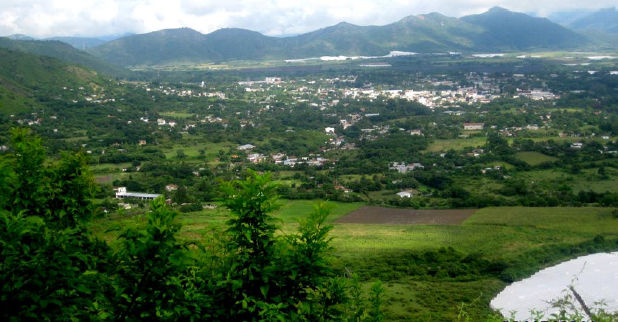
This next photo (below) shows the eastern part of the valley where the proposed Shemlon (El Porton) would have been located. There were more than 40 late Preclassic ruins in this valley area.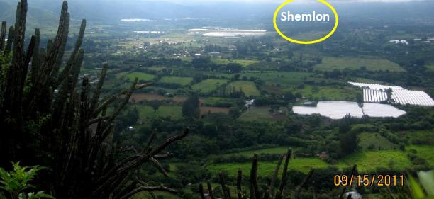
Salama Valley has a very agreeable Mediterranean type climate where all manner of fruits, vegetables, and grains can be grown. Gold, silver, and other minerals, including iron, are found in the area. The finest and hardest Jade in the world is found along the Chixoy Fault Line in the Salama area.
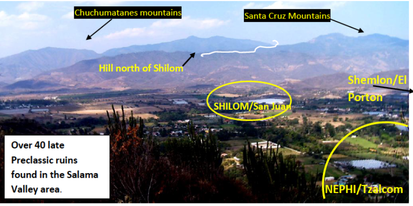
The valley looking northward from near the proposed city of Nephi, Tzalcom.
Salama is located just a few miles south of the Santa Cruz Mountains. San Juan (proposed Shilom) is located about a mile north of Tzalcom (proposed Nephi). Both of the cities of Tzalcom and San Juan had late Preclassic defensive walls around them exactly as described in the Book of Mormon. About 2 miles east of Tzalcom/Nephi is the ruin of the El Porton. It is the proposed city of Shemlon, the Lamanite capital during Limhi’s reign, and it did not have defensive walls around it. Looking north from Shilom is the large hill rising above the valley about 1000 ft, and on top of this hill is evidence of a late Preclassic tower and 3 late Preclassic reservoirs for holding water. From this large hill north of Shilom one can walk directly into the Santa Cruz Mountains precisely as described in the Book of Mormon. About 8 miles northward, one comes to the Tactic valley route to Coban, which is located about 15 miles further northward. Then the route goes down to the Icbolay/Usumacinta area, which is located about 40 miles north of Coban. The evidence is abundant that tens of thousands of Late Preclassic people occupied these areas.
Dr. F. Richard Hauck has identified more than 30 geographical criteria required by the Book of Mormon that directly correlate ancient Nephi with this Salamá basin (see his October, 2009 BMAF presentation at www.bmaf.org/articles/salama_cuenca__hauck). These criteria have been substantially verified since then by his archeological excavations in the area. He continues to find a great deal of evidence supporting this hypothesis.
Let’s quickly review the internal map noting the required alignments of the cities of Zarahemla, Manti, and Nephi. Remember that Manti is located up in elevation and in the narrow strip of wilderness, near the headwaters of Sidon and mostly south from Zarahemla.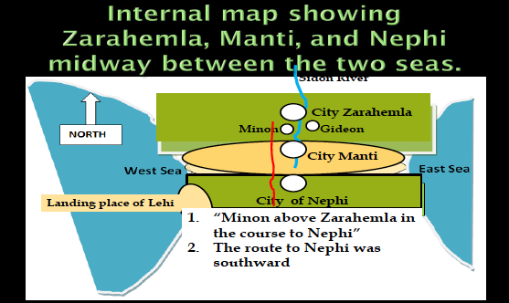
Now we will compare the Icbolay/Usumacinta model in white with the Grijalva model in green to the internal map (see pages 774 & 678 of the second edition of Exploring the lands of the Book of Mormon by Joseph and Blake Allen, 2008).
Elevations are shown in the circles in feet.
Remember also that, according to the Book of Mormon, the “course” from Zarahemla to Nephi went up southward to Minon about 15 miles or so (about half a day’s march) then southward and up substantially to Manti which was located in the narrow strip of wilderness. From there it went through the narrow strip of wilderness southward to the hill north of Shilom and then down to the city of Nephi.
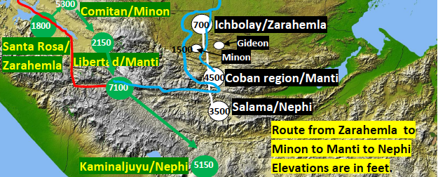
Notice the Grijalva Model shows this route from Santa Rosa (proposed Zarahemla) to Kaminaljuyu (proposed Nephi) going northeast 30 miles to Comitan (proposed Minon) instead of south as instructed by the Book of Mormon. This route, according to the Grijalva Model, would go as follows:
|
From Santa Rosa, elevation 1800 ft, one travels 30 air miles northeast across the Grijalva and then climbs to Comitan/Minon (5300 ft) instead of 15 miles south to Minon on the path to Nephi as required by the Book of Mormon.
Then one continues 33 air miles southeastward down to Lagartero/libertad/Manti (2150 ft) instead of south and up in elevation from Minon. Then southeastward (instead of south) climbing over or around the Cuchumatanes to Huehuetenango about 45 air miles (7100 ft). Then one continues southeast (instead of south) up and down over very rough terrain 80 air miles to Kaminaljuyu instead of directly down to Nephi from the hill north of Shilom as required by the Book of Mormon. |
This Grijalva route goes at least 33 miles longer than necessary because the Grijalva Model misplaces Minon thus requiring an indirect route contrary to what the book of Mormon suggests. The distances, directions, and elevations of the Grijalva Model do not match what the Book of Mormon requires.
| CONCLUSION |
Although the Grijalva Model makes an interesting and long standing argument for the Grijalva River being the river Sidon, it is necessary to remember the specific directions stated in the Book of Mormon while determining the true Sidon. When we use the six critical questions suggested earlier to examine each model, the Grijalva Model does not withstand the specific directions of the Book of Mormon.
|
1. There is no hill north of Kaminaljuyu
2. The narrow strip of wilderness cannot be seen from Kaminaljuyu 3. In the Grijalva Model not a single city or river is located in the center of the land between the east sea and the west sea as required by the Book of Mormon 4. There were no late Preclassic walls around Kaminaljuyu 5. There was no late Preclassic ruin (Shilom) north of Kaminaljuyu with Preclassic walls 6. There were too many people living in Kaminaljuyu for Nephi to have conquered, converted, or assimilated into it's culture I submit that Nephi never became king of Kaminaljuyu and that he never built a temple there after the manner of Solomon’s temple. According to 2 Nephi 5:16-2 this had to have been accomplished within 30 years or by 569 BC. It did not happen at Kaminaljuyu. |
While Kaminaljuyu does not meet any of the above criteria, the Salama valley meets all of the above criteria and many more. Therefore, this evidence from the Book of Mormon, when applied to the geography of Mesoamerica, convinces me that the Usumacinta was the river Sidon and the Grijalva was not.