RESPONSE TO MAGLEBY’S BOOK OF MORMON MODEL
by Joe V. Andersen
November 2012
joeandersen38@Gmail.com
I have studied Kirk Magleby’s Book of Mormon Model, including all of his most interesting and colorful maps, and I have carefully listened to some of his enthusiastic and informative presentations. He has presented interesting and thought provoking theories, some of them probative and possible, even probable. However I have been amazed at how many of his ideas just do not conform to the Book of Mormon requirements and to the principle of reasonableness.
To begin with I wish to state that I deem Kirk a friend. He is a most interesting scholar with a colorful and persuasive personality. As with all of us in the BMAF, Kirk has a very strong testimony of the truthfulness of the Book of Mormon. I have a very strong testimony. I also desire that we come up with a consensus map, but it must precisely follow all the requirements and statements of the Book of Mormon. I intend no malice or hard feelings toward Kirk or Garth Norman, who I also consider a friend. Kirk says his model is based about 80 percent on Norman’s map. I hope and believe that they will take no offense at what I write. We all have the same goal to determine what the authors of the Book of Mormon intended by their geographical statements and not what we hope they meant. I sincerely hope Kirk will respond in kind and correct whatever of the following statements I make and show, from the Book of Mormon, where I may be in error.
Within any quotations in this article I will be emphasizing points and making comments and these will be in red. All Book of Mormon quotations will be italicized. The following are quotes from Magleby’s Blog: Book of Mormon Resources.
|
|
"My intent with this material is to be provocative. [You succeeded.] I believe the Book of Mormon deserves to be taken seriously by much larger audiences worldwide. Demonstrating a verifiable New World setting after 182 years (1830 - 2012) would go a long way toward establishing the kind of credibility that would invite global interest in the book. Book of Mormon geography has been a fringe topic within LDS culture for generations, mired in ambiguity which has bred controversy. With the confluence of Royal Skousen's critical text, detailed historical-contextual exegesis from scholars such as Grant Hardy, and the unprecedented power and accessibility of Google Earth, significant progress toward a viable consensus map now seems possible. This article is an attempt to move the dial in that direction. [It is a very good attempt and some of your dialogue helps. However many of your conclusions and proposed locations add much more ambiguity and controversy because a goodly portion of them violate what the Book of Mormon requires.]
I sensed that I would return to this endeavor at some future date when I was prepared to make a contribution. So, to Professor Jakeman (who passed away in 1998) I am pleased to report that after 36 years I have finally created a Book of Mormon map that bears scrutiny. [It certainly needs to be scrutinized.]
In other words, this model works. It fits the text precisely and consistently." [I strongly disagree.]
|
I have selected 13 issues that I find compelling reasons why Magleby’s map is inaccurate and violates many specific requirements of the Book of Mormon. There are many more issues but this seems to be enough for the reader, as Kirk says, “to get the idea.”
|
|
-
I believe that Ammonihah was located west of river Sidon, not east.
On Wednesday, October 31, 2012 Magleby wrote in his blog called Book of Mormon Resources:
"On Thursday, August 2, 2012 I had a lengthy conversation with John L. Sorenson following his excellent presentation at the FAIR Conference about his forthcoming book, Mormon's Codex. I promised to send him an article demonstrating from the Book of Mormon that the associated Nephite polities Ammonihah, Noah and Sidom were all east of Sidon, not west of the river as most students of the text have assumed for more than 100 years."
|
This is the position that Garth Norman and Kirk Magleby have maintained for several years. I submit that this supposition is incorrect. The Book of Mormon shows that at least Ammonihah and Noah were located west of the river Sidon.
In the year 81 BC the Lamanite army had tired of killing the Ammonites in the city/land of Nephi. They crossed over the narrow strip of wilderness and attacked the city of Ammonihah which was located “in the borders of the land of Zarahemla.” After destroying Ammonihah in one day and then taking captives from the adjoining city of Noah, they were returning from Noah with their Nephite captives. Since they were already on the west side of Sidon, they crossed the river Sidon from the west to the east near the head of Sidon in the narrow strip of wilderness. Alma 16:6 says:
|
|
…Alma returned and said unto them: Behold, the Lamanites will cross the river Sidon in the south wilderness [the narrow strip of wilderness up and south of Manti], away up beyond the borders of the land of Manti. And behold there shall ye meet them, on the east of the river Sidon … [he did not say that the Lamanites re-crossed the river Sidon]. |
There can be no doubt; Sorensen was right all along. Ammonihah had to have been located west of the river Sidon. It is difficult for me to understand how Kirk could not have understood that the Lamanites were traveling from Ammonihah and Noah with their captives on the west side of Sidon. The Book of Mormon does not allow for the Lamanites to have crossed the river Sidon from the east to the west and back again especially when, according to Magleby, travel on the east side of Sidon was “so much faster.” He wrote the following in his blog article, Ammonihah:
While the Lamanite armies were making their way back home with Nephite hostages, the Nephite commander, Zoram, visited with Alma2 in Zarahemla Alma 15:18 and the prophet told Zoram and his sons precisely where to intercept the enemy and liberate their captives Alma 16:6. Zoram assembled his troops, crossed the river Sidon [from west to east] Alma 16:7, marched [over 200 miles!] to the wilderness south of Manti, and engaged the enemy immediately east of Sidon. The Lamanites had a huge head start but Zoram's army traveled so much faster east of Sidon than the Lamanites did west of it that the two of them ended up in the same place at the same time. [How do you know all this from the Book of Mormon? This is entirely too much guess work.]
Magleby and Norman claim that the city of Zarahemla was located on the lower Usumacinta River at a place called Emiliano Zapata near Palenque. They place the other cities southward and eastward from there. Norman, in his 2005 map, places Ammonihah at Tikal about 90 miles eastward from the Usumacinta River! Magleby in his map No. 3 of 27 on his Blog entitled Ammonihah, places Ammonihah about 65 miles southeast of Zarahemla and about 26 miles north from Yaxchilan at a ruin called Hormiquero II. The Book of Mormon requires that the city/land of Ammonihah be located “in the borders of the land of Zarahemla,” which means in close proximity. How can 65 air miles be considered in close proximity?
Why would the Lamanite army have marched west (or perhaps south) just to cross the huge crocodile-infested Usumacinta River (Sidon) and then have traveled on the west side of Sidon if the west side of Sidon was so much slower? Why would they go the longer and harder route to climb up into the narrow strip of wilderness in order to cross back over from the west to the east of Sidon? This makes no sense. If travel was easier and faster on the east side of Sidon for the Nephites then it would have also been easier and faster for the Lamanites. Why did the Lamanites not stay on the east side of Sidon? Had they stayed on the east side of the Usumacinta River they would never had to have crossed the river even one time let alone two times and they would have returned to the city/land of Nephi before the Nephites had even begun to follow them. Something smells with Magleby’s logic. What smells is the theory that Ammonihah could have been located on the east of Sidon.
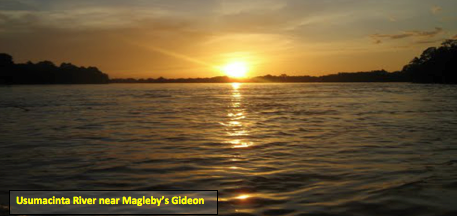
One look at the Usumacinta River (the worlds 7th largest river) in the area near Yaxchilan, about where Magleby claims the Lamanites would have to have crossed to the west side of Sidon and one then understands why no army would have desired to cross it until near the headwaters where it was smaller and more shallow. This picture emphasizes the fallacy of Kirk’s arguments:
.png)
Norman places Ammonihah at Tikal, about 90 miles east of Sidon and about 100 miles north of Sidon. Tikal is also located about 150 miles mostly east from near Palenque. How can one possibly and reasonably go east when the Book of Mormon says, or at least strongly infers, that Alma went west of Zarahemla and west of Sidon to Melek and then north of Melek to Ammonihah?
Tikal could not possibly have been a Nephite city because Tikal was started before 300 BC and was continuously occupied by the Maya until after AD 900. Thus it was in existence many years before Mosiah merged with the Mulekites. There is no evidence in the Book of Mormon that the Nephites ever conquered or converted Tikal. Never in the Book of Mormon does it indicate that the Nephites were the aggressors except during Moroni’s time when he chased “all of the Lamanites” out of the east-sea wilderness into their own lands south of the land of Zarahemla in the year 72 BC.
Since Ammonihah was located west of the Sidon, then not only is Magleby’s conjecture in error but most of his other proposed Nephite cities are also incorrect because they are based on many incorrect premises as will be shown hereafter.
-
I believe that Melek was located west of the city of Zarahemla
not east and south.
That Ammonihah was in fact located westerly of the city of Zarahemla is confirmed in Alma chapters 5 through 8. In the beginning of the year 83 BC, Alma gave the judgment seat to Nephihah and commenced his mission to all the land of Zarahemla, which at that time covered an area only slightly larger than about 40 miles radius from the city of Zarahemla1
About 83 BC, Alma 5:1-3 states:
|
|
1….Alma began to deliver the word of God unto the people, first in the [city/] land of Zarahemla, and from thence [the city] throughout all the land [of Zarahemla]. Alma 6:7 …he departed from them, yea from the church which was in the city of Zarahemla, and went over upon the east of the river Sidon, into the valley of Gideon, there having been a city built, which was called the city of Gideon [not more than 12 miles east and south of the city of Zarahemla], which was in the valley that was called Gideon…Alma 8:1 …Alma returned from the [city/]land of Gideon…yea he returned to his own house at Zarahemla to rest himself from the labors which he had performed.
2. And thus ended the ninth year (83 BC)…Remember Alma had been seriously wounded in the battle of the Amlicite insurrection 4 years earlier.
3.…in the commencement of the tenth year [82 BC]…Alma departed from thence [his home in the city of Zarahemla] and took his journey over into the land of Melek, on the west of the river Sidon on the west by [near but not in] the borders of the wilderness. [I believe this refers to the foothills of the narrow strip of wilderness just like Gideon and Minon were in or near the foothills of the narrow strip of wilderness.]
|
Twice the term “west” is used and clearly he left from “thence” meaning his home in the city of Zarahemla. He had just returned from an exhaustive mission on the east and south of the city. Why would he have returned to the east of Zarahemla when there were people on the west that he desired to visit? His mission was to be to all of land of Zarahemla at that time and not just to the east and south of Zarahemla.
Contrary to what Magleby claims, there is no evidence in the Book of Mormon that at this time period Zarahemla was exclusively expanding across the Usumacinta/Sidon River to the east. This was only 4 years after the devastating Amlicite civil war and the greater land of Zarahemla had not expanded into the east-sea area yet. Clearly the expansion was also taking place to the west of the city of Zarahemla.
The starting point of Alma’s mission to Gideon was the city of Zarahemla. If “east of the Sidon to Gideon” meant eastward of the city of Zarahemla, which it did, then the same verbiage within the same verses should give rise to the same meaning, namely “on the west of river Sidon” must have as its reference point the city of Zarahemla and not some imaginary location some 80 miles southeast. Both missions had the same starting position and therefore east meant east of the city and west meant west of the city.
On Magleby’s map No. 5 of 7 it shows that his proposed Melek is located at or very near the ruins of Yaxchilan located more than 80 miles (Magleby says 9 days travel) from the city of Zarahemla. Actually it is located 60 miles south and 45 miles east from Magleby’s proposed city of Zarahemla (Emiliano Zapata, Mexico). How can that possibly square with the Book of Mormon requirement that Alma left his home and traveled to the “west of the river Sidon on the borders west by the wilderness?” If it was noteworthy for Mormon to indicate Alma’s long journey of 3 days from Melek to Ammonihah, then why did he not tell us that Alma traveled 9 days to get to Melek? Where does the Book of Mormon indicate or infer that the tired and aging Alma journeyed 9 days south and east to Melek? Where do all these specific details come from? Certainly not from the Book of Mormon!
Also remember that Melek had to have been located near Zarahemla so that the Nephites could protect the Ammonites, and the Ammonites could contribute to the sustenance of the Nephite armies. If Ammonihah, 3 days north of Melek, was too far for the Nephites to protect, then how could the Nephites at that time have protected Melek, 9 days from Zarahemla? And how could the Ammonites have assisted in providing for the Nephite armies? If Melek was located on the west of the river Sidon 80 miles southward from the city of Zarahemla and hence on the path to Manti and thence to the land of Nephi, then why did the Lamanites never attack the indefensible Melek? This whole scenario just does not fit what the Book of Mormon is describing. While there is a strong inference that Melek was located west of the city of Zarahemla, there is no inference in the Book of Mormon that Melek was located south and east of Zarahemla.
-
I believe that Gideon and Minon were not located 15 miles apart as claimed by Magleby. They were located not more than 5 miles apart and not more than 8 to 12 miles southward from Zarahemla.
On Magleby’s maps 3, 4 and 5 of 7, in his article regarding the 7 churches, he places Gideon about 5 miles east of Sidon and 25 miles southeast of Zarahemla. He places Minon about 15 miles west of Gideon and about 30 miles south of Zarahemla. Such placements violate the descriptions given in the Book of Mormon. The Book of Mormon requires that the maximum distance between Minon and Gideon cannot exceed about 5 to 6 miles (half a night’s march). It also requires that both Minon and Gideon cannot be more than 12 miles (less than one day’s march) or so southerly of the city of Zarahemla and that the river Sidon flowed between them.
On the first day of the Amlicite battle, Alma crossed the river Sidon and met the Amlicites on the hill Amnihu which was located east of Zarahemla and east of the river Sidon. After a serious battle on the hill, the Amlicites fled southward to the valley of Gideon where Alma stopped pursuing them for the night. Thus the distance from the river crossing to Gideon cannot be more than one day’s march, probably including the crossing of the Sidon (not more than about 12 miles). While Alma was sleeping, his scouts followed the beaten and tired Amlicites westward. They crossed the river Sidon and by midnight the Amlicites met the Lamanites in the land of Minon. The total distance could not have exceeded a distance of a half night’s march or about 5 miles, including the crossing of Sidon. The scouts then hurried back across the Sidon to Gideon where the next morning they informed Alma:
|
|
Alma 2:24-26 24….we followed the camp of the Amlicites, and to our great astonishment, in the land of Minon, above the land of Zarahemla, in the course of the land of Nephi, we saw a numerous host of the Lamanites; and behold, the Amlicites have joined them; 25. And they are upon our brethren in that land; and they are fleeing before them with their flocks, and their wives, and their children, towards our city; and except we make haste they obtain possession of our city, and our fathers, and our wives and our children be slain. [It is clear that both armies easily could have reached the city in less than one day] 26. …the people of Nephi took their tents and departed out of the valley of Gideon towards their city, which was the city of Zarahemla. 27. …as they were crossing the river Sidon, the Lamanites and the Amlicites, being as numerous almost, as it were, as the sands of the sea, came upon them to destroy them. [The distance from Minon and Gideon to the city of Zarahemla therefore had to have been about the same and in no case could it have exceeded the distance of one day’s travel and more likely it was much less.]
|
 |
|
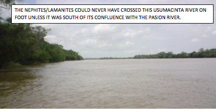
Think about it! If Magleby and Norman are right, then Alma and his army had to cross this river the first day and then fight all day. Then during the night the wounded and tired Amlicites had to cross it before midnight. The scouts had to cross it before midnight while following the Amlicites, and again when they returned the next morning. Then about noon or so that next day, Alma and his army had to cross it again (except this crossing had to have been located only about 8 miles or so northward from Gideon) in order to stop the Amlicites and Lamanites from reaching the city Zarahemla. (According to the Book of Mormon there were two separate crossing places on the Sidon about 10 miles apart.). Imagine Alma and his whole army of many thousands of soldiers crossing this river on foot and then standing in this river while Alma personally fought king Amlici and the Lamanite guards in order to clear a place where Alma and his army could climb out of the river Sidon (Alma 2:27-35)! It defies reason. It defies the descriptions and intent of the Book of Mormon. I submit that it did not happen anywhere on the Usumacinta River north of its confluence with the Pasion River. It is impossible to cross the river on foot because the river is too wide, deep or swift. (See Rolando Amado’s Email) 2
This area of the Usumacinta River could not have been the general location of Gideon, or Minon, or even of the city of Zarahemla as proposed by Magleby and Norman. This area of the Usumacinta River is just slightly more narrow (but deeper) than the area of the ¾ mile wide Mississippi River where Rod Meldrum and company propose that the city of Zarahemla was located across the river from Nauvoo, Illinois. Both proposed locations are most unreasonable and do not conform to the requirements of the Book of Mormon.
-
I believe that city Bountiful could not have been located more than 5 miles from Mulek or 40 miles inland as proposed by Magleby.
Magleby agrees with the Allens when they place Mulek at the ancient site of Cerros, on the Chetumal Bay in Belize. They place the city Bountiful inland about 40 miles at Dzibanche in the Yucatan. This violates what the Book of Mormon requires.
In the year 64 BC the Lamanites had captured all of the Nephite east-sea cities except city Bountiful. They occupied the heavily fortified city Mulek. Moroni had just returned from organizing the defenses of the west-sea cities under the command of Antipus. Moroni and Teancum were stationed in the east-sea city Bountiful and had decided on a stratagem to retake Mulek which was located right on the east seashore. Alma 52:22-23, states:
|
|
22. …Teancum should take a small number of men and march down near the seashore; and Moroni and his army, by night, marched in the wilderness on the west of the city Mulek; and thus, on the morrow, when the guards of the Lamanites had discovered Teancum, they ran and told it unto Jacob, their leader. [If Cerros was Mulek then Moroni’s army would have been stationed on the west side of Cerros right on the seashore and Teancum would have been waiting on the northeast side of Cerros near the seashore. Retreating northward from there would have meant that Teancum would have ended up in the Chetumal Bay (see map below). Marching westward would have placed the Lamanites in the middle of Moroni’s army.]
23. …the armies of the Lamanites did march forth against Teancum, supposing by their numbers to overpower Teancum…And as Teancum saw the armies of the Lamanites coming out against him he began to retreat down by the seashore northward. [This infers that they never left the seashore and always traveled northward. This scripture does not support the idea that they “circled back” somewhere (see pages 603-of Exploring]. Had they “circled back”, after leaving Cerros and after traveling northward on the seashore, they would have traveled a much greater distance. They would also have to have marched southward to go around Moroni’s army and then around the Bay. Then they would have crossed a good sized river and a very swampy delta which would have substantially reduced the distance they could have marched in a half a day. The Book of Mormon never says or infers that they went southward or that they circled back.]
27. …the Lamanites did pursue Teancum until they came near the city Bountiful, and then they were met by Lehi and a small army, which had been left to protect the city Bountiful.[It sounds like the Lamanites followed Teancum northward along the seashore until they came near to the city Bountiful. There is no indication they ever crossed over a river or a swampy delta.]
28. …when…the Lamanites beheld Lehi…coming against them, they fled in much confusion, lest perhaps they should not obtain the city Mulek before Lehi should overtake them…. [They clearly could have made it back to Mulek within the same day. Therefore, the farthest distance that city Bountiful could have been located from Mulek was not more than a half day’s march, (not a day’s march as suggested at page 604, of Exploring). I submit that Mulek and Bountiful could not have been more than 5 miles or so apart. This is also more consistent with what Exploring suggests at pages 411 and 412 that a day’s journey was more like 8 miles instead of 30 or 40 miles. Magleby claims it is more likely 10 or 11 miles in a day.]
|
Therefore, neither Kohunlich nor Dzibanche could have been the city Bountiful because each is located m ore than 30 miles as the crow flies due westward (instead of north) from Cerros. Also one could not have traveled northward from Cerros along the seashore to get to either of these locations as required by the Book of Mormon. One would have to have “circled back;” traveled southward; and then crossed a large river and a swampy delta (see map below).
Nothing in the Book of Mormon justifies such claims.
.png)
I submit that, according to the Book of Mormon, the armies of Teancum and the armies of the Lamanites did not march across a large river and swampy delta and about 40 miles inland to the city Bountiful at Dzibanche in a half day. I further submit that this scripture requires city Bountiful to have been located not more than about 5 miles northward from Mulek and be very close to the seashore. Notice on the above map that there are no “plains” between Cerros and Dzibanche or Kohunlich but there is a river, a swampy delta, and a jungle. Therefore Magleby is in error in claiming that Cerros was Mulek or that Dzibanche was city/Bountiful.
About two years prior to Moroni’s arriving at city Bountiful from the west sea, Teancum had made an unsuccessful attempt to retake Mulek. Notice that both Teancum and Amalickiah were camped near the city/land Bountiful. Amalickiah was actually camped on “the beach by the seashore,” proving that city Bountiful was not located inland but very near the beach.
(About 66 BC) Alma 51:32 states,
|
|
”…Teancum and his men did pitch their tents in the borders of the [east-sea city/] land Bountiful; and Amalickiah did pitch his tents in the borders [of the city/land Bountiful] on the beach by the seashore…” [Teancum killed Amalickiah that night. Teancum certainly did not walk 40 miles at night in the jungle to the seashore and back after he killed Amalickiah. The next day the Lamanites retreated back to Mulek and remained there until Moroni returned with his army from the west-sea area. It sounds to me like they returned via the seashore route and not an inland route]. |
Therefore, neither Dzibanche nor Kohunlich could have been city Bountiful (See map above). Cerros could not have been Mulek.
An additional reason why these cities could not have been Nephite cities is that all of them were occupied and being developed prior to 120 BC when the entire land of Zarahemla was but a small area not over 20 miles wide and and 20 miles long. Therefore these cities could not have been built by the Nephites.3
-
I believe that Morianton and Lehi could not have been more than 3 or 4 miles apart.
Magleby and Norman place the city of Morianton on the Belize east coast somewhere near Belize City. Magleby places Lehi about 30 miles south of Morianton. Norman places Lehi about 40 miles south of Morianton. This clearly violates what the Book of Mormon requires.
In the year 68 BC there was peace in all the land of Zarahemla except on the east coast where a border dispute arose between Morianton and Lehi. This was less than 4 years after these defensive city/lands were first established. There is no indication in the Book of Mormon that these lands encompassed large areas as claimed by Magleby.
Alma 50:25-26 states:
|
|
25. …a contention…took place among them concerning the land of Lehi, and the land of Morianton, which joined upon the borders of Lehi; both of which were on the borders by the seashore.
26….the people who possessed the land of Morianton did claim a part of the land of Lehi; therefore there began to be a warm contention between them…[These could not have been large land areas but small city/lands on or very near the seacoast. This was less than 4 years after they were built. If both cities were located “on the borders by the seashore”, and if both were located on the borders of each other then they must have been located as close to each other as they were from the seashore. This means that they could not have been located more than a couple of miles from each other.] |
I can understand a border dispute, for example, between Orem and Provo, but not between Orem and Salt Lake. We must be reasonable. In the year 72 BC these cities were built new as defensive cities to keep the Lamanites south of the land of Zarahemla. How can one reasonably claim that a border dispute took place 4 years later with another small city located more than 30 miles away (3 or 4 day’s march)? The Book of Mormon does not support Magleby and Norman’s proposed locations for these cities.
-
I believe that all of the east-sea coastal cities had to have been located not more than 50 miles northward from the city/land of Moroni.
Most Mesoamerican scholars, including Magleby, agree that Moroni was located at the eastern end of the narrow strip of wilderness about where an extension thereof would have intersected with the Bay of Honduras. Magleby, Norman, and the Allens place city Bountiful at Dzibanche in the Yucatan almost 200 air miles from the city of Moroni. Again this violates the description and intent of the Book of Mormon.
In 72 BC Moroni established a military defensive line that extended from the west sea to the east sea that divided the greater land of Zarahemla from the greater land of Nephi. This was known as the narrow strip of wilderness which was a mountain chain extending along the Chizoy fault line from the Pacific near Izapa to the Bay of Honduras in the Caribbean. This was a major expansion of the greater land of Zarahemla and it stretched Moroni’s resources to the maximum.
He drove “all of the Lamanites” who had been scattered in the east-sea area into their own lands which were located south from wherever the line between the land of Nephi and the land of Zarahemla was located within the area of the narrow strip of wilderness. Then he relocated many Nephites from the city/land area of Zarahemla to fill in this area on the east sea coast to keep the Lamanites from re-entering the east-sea area then controlled by the Nephites. He built at least 7 new cities on or very near the east sea coast. He did not chase all the Maya out the Peten and out of Belize.
4
How could the Nephites have control of all of these cities if they were located in an area over 200 miles long and beyond the Maya heartland? Why would he have located the city Bountiful north of Lamanai where thousands of Maya had been living since 1500 BC? It makes no sense and yet that is what Magleby, Norman and the Allens would have us believe.
Since Mulek and Bountiful were located no farther than 5 miles apart, and since Moronihah and Lehi had to have been located within a couple of miles of each other, and since the people at Moroni and Lehi gathered for safety at nearby Nephihah, then following this pattern, why would any of the other cities have been located more than a few miles from each other? Moroni needed to provide a military defensive area where these new cities could support and defend each other and keep the Lamanites from re-entering the eastern part of the land of Zarahemla by way of the non-mountainous area near the east sea.
If there were 5 miles or so between each of these 7 cities that were all located near the east sea, then the maximum distance from Moroni to city Bountiful would not have exceeded about 40 miles. Therefore all of the locations of the east-sea cities, as claimed by Magleby and Norman and the Allens, must be in error except for the city/land of Moroni.
-
I believe that the Nephites never occupied the area north of the east-sea city Bountiful. Therefore the land Bountiful could not have been located in northern Belize, northern Peten or the Yucatan as proposed by Magelby.
Magleby claims that the land Bountiful included the northern part of Belize, the area north of the Guatemalan border and the entire Gulf coast from just south of Campeche to Coatzacoalcos. Not only is such a claim unreasonable, it is not supported by the Book of Mormon.
Clearly the Nephites were tenacious in defending the east-sea city Bountiful and in not allowing the Lamanites to get into the land northward from there. There is also no evidence that the Nephites themselves ever settled or traveled northward from the city Bountiful.5
Why? I submit that it was because of the millions of lowland Maya that occupied these areas to the north and to the west of city Bountiful at that time (65 BC).6
In Helaman 5:14-16 it states:
|
|
“[Helaman’s sons]…teach the word of God among all the people of Nephi, beginning at the city Bountiful; 15. And from thenceforth [southward] to the city of Gid; and…to the city of Mulek: 16….even from one city to another, until they had gone forth among all the people of Nephi who were in the land southward.” |
Because all of the Nephites in all of the land southward were visited by Helaman’s sons and since they did not go north of city Bountiful, then it is reasonable to conclude that no Nephite lived north of the city Bountiful because Helaman’s sons did not go north of the city Bountiful. Why? Because there were no Nephites living there. Therefore the areas proposed by Magleby in the northern Belize, northern Peten and the Yucatan and the areas of Tabasco to be the land Bountiful are incorrect according to the Book of Mormon.7
The following 3 issues will be treated together. I believe that:
-
Jershon could not have been located at Lamanai, Belize 120 air miles north of Moroni or about 30 miles inland.
-
Antionum could not have been located 75 miles inland from Moroni.
10. Jershon and Antionum could not have been located 80 miles apart.
Both Magleby and Norman place the location of these cities as stated above. This violates what the Book of Mormon requires.
8. Jershon could not have been located at Lamanai, Belize 120 air miles north of Moroni or about 30 miles inland.
Most scholars, including Magleby and Norman, agree that the city/land of Moroni was located at the east end of the narrow strip of wilderness about where an extension thereof would have intersect with the Gulf of Honduras and hence near “the line of possessions of the Lamanites.” The scriptures require that the land of Jershon must be adjacent to the narrow strip of wilderness and north of Antionum near the east sea. Reading the relevant scriptures together regarding the locations of Moroni, Jershon, and Antionum clearly show that the relationship of these three cities had to have been one of close proximity to each other and to the narrow strip of wilderness that formed the line of possessions of the Lamanites:
Alma 27:22-26 states:
|
|
77 BC 22. …we will give up the land of Jershon, which is on the east by the sea, which joins the land Bountiful, which [Jershon] is on the south of the land Bountiful…
26…and they went down into the land of Jershon [from near Manti in the narrow strip of wilderness].
23…we will set our armies between the land Jershon and the land Nephi [which land of Nephi was located to the south of, and probably included some of, the narrow strip of wilderness], that we may protect our brethren in the land Jershon. [I believe that this area where Moroni set his armies later became the city/land of Moroni.]
74 BC Now the Zoramites had gathered themselves together in a land which they called Antionum, which was east of the land of Zarahemla, which [Antionum]lay nearly bordering upon the seashore, which [Antionum] was south of the land of Jershon, which [Antionum] also bordered upon the wilderness south [eastern part of the narrow strip of wilderness], which wilderness was full of the Lamanites. [Antionum was located immediately adjacent to the Lamanites at the very edge of the narrow strip of wilderness. It could not have been located 30 miles inland from Moroni.]
72 BC. Alma 50:13 states: …the Nephites began the foundation of a city, and they called the name of the city Moroni, and it was by the east sea; and it was on the south by the line of possessions of the Lamanites. [Remember that in the year 74 BC the Zoramites at Antionum had become Lamanites and remember that Moroni had placed his army between the Ammonites at Jershon and the Lamanites (Alma 43:4)] Alma 51:22 …the Lamanites had come into the land of Moroni, which was in the borders by the seashore. [Because Moroni was located by the borders of the seashore and adjacent to the line of possessions of the Lamanites, and because Antionum was located next to the line of possessions of the Lamanites and adjacent to the narrow strip of wilderness , and had become Lamanites, then Antionum could not have been located some 30 miles inland.]
|
In the year 77 BC the army camp of the Nephites was placed between Jershon (located on the east seashore) and the line of possession of the Lamanites. It is inconceivable, based on these scriptures, that Jershon could have been located 120 miles north of Moroni at the huge Preclassic Maya cite of Lamanai, (as claimed by Norman) or that Jershon could have been located, not on the east seacoast as required by the Book of Mormon, but inland some 30 miles (as claimed by Magelby). The Nephites had agreed to protect the Ammonites and so placed their armies between Antonium, which was on the line of possessions of the Lamanites, and Jershon. I submit that the Book of Mormon requires that all three of these areas could not have been located more than a few miles apart and that all of them were located close to the line of possessions of the Lamanites.
Another reason Antionum could not have been located in the Nephite lands north of the narrow strip of wilderness is that by the end 74 BC the Zoramites became Lamanites (Alma 43:4). In the year 72 BC all of the Lamanites, (including the Zoramites if any were there), were chased out of the east-sea area, therefore Antionum could not have been located some 30 miles inside the greater land of Zarahemla but had to have been located right at the line of possession of the Lamanites. Again Magleby’s Model does not conform to the requirements of the Book of Mormon.
9. Siron could not have been located in the land north of the narrow strip of wilderness.
Magleby erroneously places Siron in the land north of the narrow strip about 50 miles inland from the east sea and about 60 miles north of the city/land of Moroni (See map 6 of 11 of his article entitled Sidom East then West dated Feb 17, 2012).
In 74 BC Alma served a mission among the Zoramites just before they became Lamanites. Antionum was located near to the east seashore, but not on it. It was also south of Jershon (which was located closer to the east seashore). Antionum bordered on the eastern part of the narrow strip of wilderness where many Lamanites were living. Corianton was residing in the city/land of Antionum with his father right at the line of possession of the Lamanites. He left the mission and went “over into” the land of Nephi to see the Lamanite harlot, Isabel.
Alma 39:3 states:
|
|
Thou didst do that which was grievous unto me; for thou didst forsake the ministry and did go over into the land of Siron among the borders of the Lamanites, after the harlot Isabel. The term “among the borders of the Lamanites” clearly means within the borders of the Lamanites and not within the borders of the Nephites. Siron had to have been located south of the line of possession of the Lamanites, meaning south of that part of the narrow strip of wilderness that was controlled by the Nephites.
|
Right after Alma’s mission, the Zoramites became Lamanites. Siron was a Lamanite city that Garth Norman correctly understands had to have been located at least south of the land of Zarahemla (see his map). Therefore Magleby’s proposed location of Siron some 30 miles north of the line of possession of the Lamanites is in error. Again Magleby’s map does not fit the text precisely and consistently.
10. I believe that Joshua could not have been located near La Venta or anywhere near the Gulf of Mexico.
On Magleby’s map in his article dated July 28, 2012 it locates Joshua near the site of La Venta on the Gulf of Mexico near where the Coatzacoalcos River enters the Gulf. Again this violates what the Book of Mormon requires.
Apparently Magleby agrees with the Allens’ erroneous conjecture that the Book of Mormon describes two west seas:
1. The Pacific, west of the narrow strip of wilderness and west of the west-sea land Bountiful;
2. The west side of the Yucatan Peninsula in the Gulf of Mexico. That is the only way they can claim to justify placing Joshua near the Jaredite north sea (the Gulf of Mexico) instead of on the pacific. This also violates what the Book of Mormon requires.
The last war between the Lamanites and Nephites began in the city of Zarahemla and by the river Sidon. In the year AD 327 when Mormon had just been made leader of the Nephite armies at age 16, the “Lamanites did come upon us with exceedingly great power, insomuch that they did frighten my armies; therefore they would not fight and they began to retreat towards the north countries (Mormon 2:3).” They did not go into the north countries (the Jaredite land northward) yet. They only started their retreat towards the Jaredite land northward. Which way did they go from Zarahemla? Mormon 2:6 states “6. And we marched forth and came to the land of Joshua, which was in the borders west by the seashore.” This is the only scripture mentioning Joshua by name.
Norman claims they went south, from the city of Zarahemla, 100 miles to Angola and then westward to David (near Chiapa de Corso). They then traveled westerly about 90 miles and settled at Joshua which he locates near present day Tonala, Mexico, on the Pacific coast.
Magleby claims they went about 150 miles west from the city of Zarahemla (Emiliano Zapata near Palenque) to Joshua (La Venta) on the Gulf of Mexico. He does not identify Angola or David.
Both cannot be right. As I maintain in my article entitled Joshua near the west sea located at BMAF.org, if Joshua was located on the Pacific coast then the entire Nephite lands can be properly deciphered but if Joshua is placed on the Gulf of Mexico coast the entire geography of the Nephites is compromised and frustrated. This is such an important issue that I felt it necessary to identify every reference to the west sea to show that they all refer to the Pacific coast:
Alma 22:27…which was divided from the land of Zarahemla by a narrow strip of wilderness, which ran from the sea east even to the sea west, [The Pacific]…and thus were the Lamanites and the Nephites divided.
Alma 22:32 And now, it was only the distance of a day and a half’s journey for a Nephite, on the line Bountiful and the land Desolation, from the east to the west sea; [The Pacific]
Alma 22:33. And it came to pass that the Nephites had inhabited the [west-sea] land Bountiful, even from the east unto the west sea [The Pacific], and thus the Nephites in their wisdom, with their guards and their armies, had hemmed in the Lamanites on the south, that thereby they should have no more possession on the north, that they might not overrun the land northward.
Alma 50:11. And thus he cut off all the strongholds of the Lamanites in the east wilderness, yea, and also on the west, fortifying the line between the Nephites and the Lamanites, between the land of Zarahemla and the land of Nephi, from the west sea, [The Pacific] running by the head of the river Sidon—the Nephites possessing all the land northward, yea, even all the land which was northward of the [west sea] land Bountiful, according to their pleasure.
Alma 50:34 …they did not head them until they had come to the borders of the land Desolation; and there they did head them, by the narrow pass which led by the sea into the land northward, yea, by the sea, on the west…[The Pacific].
Alma 52:11 …I would come unto you, but behold, the Lamanites are upon us in the borders of the land by the west sea; [The Pacific] and behold, I go against them, therefore I cannot come unto you.
Alma 52:12. Now, the king (Ammoron) had departed out of the land of Zarahemla, and had made known unto the queen concerning the death of his brother, and had gathered together a large number of men, and had marched forth against the Nephites on the borders by the west sea.[The Pacific]
Alma 53:8 …the armies of the Lamanites, on the west sea, south,[The Pacific] while in the absence of Moroni on account of some intrigue amongst the Nephites, which caused dissensions amongst them, had gained some ground over the Nephites, yea, insomuch that they had obtained possession of a number of their cities in that part of the land.
Alma 53:22. And now it came to pass that Helaman did march at the head of his two thousand stripling soldiers, to the support of the people in the borders of the land on the south by the west sea [The pacific].
Alma 63:5 …Hagoth, ...built him an exceedingly large ship, on the borders of the land Bountiful, by the land Desolation, and launched it forth into the west sea,[The Pacific] by the narrow neck which led into the land northward.
Helaman 3:8. And it came to pass that they did multiply and spread, and did go forth from the land southward to the land northward, and did spread insomuch that they began to cover the face of the whole earth, from the sea south to the sea north, from the sea west [The Pacific] to the sea east.
Helaman 4:7. And there they did fortify against the Lamanites, from the west sea [The Pacific] even unto the east; it being a day’s journey for a Nephite, on the line which they had fortified and stationed their armies to defend their north country.
Helaman 11:20 …the people of Nephi began to prosper again in the land, and began to build up their waste places, and began to multiply and spread, even until they did cover the whole face of the land, both on the northward and on the southward, [of the narrow strip of wilderness] from the sea west [The Pacific] to the sea east [Bay of Honduras].
I do not see how there can be any doubt that every reference in the Book of Mormon to the west sea is referring to the Pacific. There is no justification in the Book of Mormon to believe that when Mormon says: “And we marched forth and came to the land of Joshua, which was in the borders west by the seashore” that it means anything but the Pacific. Magleby loves to find patterns to prove points. Here is a big pattern. Why make an exception? Joshua was located on the Pacific side and not on the Gulf of Mexico near La Venta or anywhere near the Gulf of Mexico. Joshua had to have been located on the Pacific side. I believe Richard Hauck properly located Joshua on the Pacific side near Izapa in 1988. It is really sad that most Book of Mormon scholars have not taken Hauck seriously in the past. Hopefully they will now begin to understand his profound and accurate understanding of the geography of the Nephites in the Book of Mormon.
11. I believe that not one of the 7 churches established by Alma1 was located outside the city/land of Zarahemla according to the Book of Mormon.
Magleby makes an interesting attempt at identifying the locations of the 7 churches established by Alma I in the year 120 BC. The problem is that not only is this based on sheer conjecture and guess work, but it is also unreasonable and it violates what the Book of Mormon describes. The following is his map showing one of the seven churches at Melek (Yaxchilan), located about 80 miles or 9 days distance to the south and east; Another church at Ammonihah is located at Hormiquero II about 60 miles southeast of Zarahemla across the Usumacinta River.
When carefully reading what the Book of Mormon actually says, one realizes that these 7 churches were all established about the year 120 BC, right after Alma and Gideon had arrived at the city/land of Zarahemla. They were all located within the defined limits of the city/land of Zarahemla at that time. This encompassed an area about 20 miles by 20 miles, maybe the size of the Salt Lake valley. Therefore Melek, Ammonihah, Gideon, and Minon had not yet even been established (see my article located at BMAF entitled, Zarahemla: Its Rise and Fall.) Clearly no community had been founded at the valley of Gideon yet because Gideon did not arrive in Zarahemla until 120 BC. The city of Gideon was not established until 33 years later (about 87 BC) and four years after Alma I had died in 91 BC (Alma 29:44-56).
Since Ammonihah was not located east of the river Sidon but west of Zarahemla and west of Sidon, then the cities of Melek and Ammonihah, as shown on the following map, are in error. The distances shown on the maps below are much too great to satisfy the requirements of the Book of Mormon. The 7 churches were all located within the city/land of Zarahemla that existed in the year 120 BC, an area similar in size to the Salt Lake Valley.
The reason Alma formed many churches in the year 120 BC, was because the people could not all hear the word of God in “one assembly” in the city of Zarahemla (Alma 25:20) as they had been doing. All seven churches represented 7 bodies (like wards or stakes) of members within the city of Zarahemla. Alma did not travel 7 or 9 days to organize a church in a city that did not even exist at that time. This is just too much unfounded speculation.
-
I believe that there was not one continuous land Bountiful and it was not 650 miles long. There were two comparatively small separate coastal lands Bountiful.
Magleby’s maps show only one land Bountiful and it is a strip of land that begins just south of Tulum, Mexico and continues westward, and north of the mammoth El Mirador complex, to Laguna de Terminos. It takes in all of Tabasco to the Isthmus of Tehuantepec. Then it continues southward including the east half of the Isthmus of Tehuantepec to the Mar Muerto and then southeast to about Tonala. This is an unbelievable unbroken line of possession and/or control of over 650 miles. Moroni had to have accomplished this feat within his lifetime from 74 BC to 56 BC a period of only 18 years. Can anyone seriously believe that that would have been possible? Clearly he spent his entire lifetime between the east sea cities and the west sea cities and around the city/land of Zarahemla, including Manti in the narrow strip of wilderness. Every year of his life is fully accounted for and not one of them gives rise to even the hint that he traveled north of city Bountiful, or to the Gulf coast or the “narrow neck of land.” He was busy just trying to maintain the narrow strip of wilderness as a defensive line between the land of Nephi and the land of Zarahemla. There is no scriptural support for such a proposition.
Look at the incredible distances of some of the places Magelby claims that Moroni occupied or controlled.
The scripture Magleby points to in order to have some justification for the above is found in Alma 22:33: which states (about the year 77 BC) “…the Nephites had inhabited the land [west-sea] Bountiful, even from the east unto the west sea.” Some scholars believe that this scripture infers an east sea and therefore they believe that the Book of Mormon requires that there was only one continuous land Bountiful. (See my article located at BMAF entitled Three Separate Lands Bountiful: Where Located? What Size? To Which Bountiful did Christ did Christ come?)
Magleby agrees with the Allens who claim that the term in Alma 22:32 “from the east to the west sea” did not mean the east sea (see page 411 of Exploring). Then 2 verses later they claim that the same term “from the east unto the west sea” does mean the east sea and that this time the term ”west sea” is not the Pacific but the Gulf of Mexico. Where is the consistency and faithfulness to the text?
I believe that Magelby, realizing the problem the Allens had in making the land Bountiful one continuous land even greater in size than the Land of Zarahemla, which also included the lowland Maya, decided to circumvent the lowland Maya. He decided to make the land Bountiful to form a 650 mile band around the Maya at El Mirador and around the Lacandon wilderness and around land of Chama (Manti) and the Grijalva Depression and then to go through the eastern half of the Isthmus of Tehuantepec to the Pacific Ocean and then southward stopping at about Tonala. Thereby he was safe having the land Bountiful be continuous and touching the east sea, Allens’ west sea at the Gulf of Mexico, and Hauck’s west-sea Bountiful on the Pacific, hoping to make everyone happy.
As shown above, the Book of Mormon had only one west sea, the Pacific. Either the authors meant to imply an east sea in verse 32 or they did not. If they did not imply an “east sea” in verse 32 then they also did not imply an “east sea” in verse 33. Who are we to devine that they deceived us and that they really meant an east sea in one verse but not the other? Or that they deceptively meant two different west seas?
CONCLUSION:
When Rod Meldrum, the Guru of the North America-only theory, realized that if the Mississippi was to be the river Sidon of the Book of Mormon then there must have been a place near Zarahemla where the Nephite army could have crossed it on foot. He found a place called the De Moines Rapids, a ¾ mile wide area near and just north of Nauvoo and claimed (without corroboration) that they crossed there. In his article dated June 4, 2010 entitled The Mississippi: could it have been the river Sidon, he makes the following unsupported yet self defeating statement:8
|
|
In fact, the river at Nauvoo was actually shallow enough to cross on foot! This area was called the Des Moines rapids and riverboats had to off-load their cargo to pass these rapids prior to the building of locks/dams across the river. The Des Moines Rapids are known historically to have been less than 2.4 feet deep, making this the first location upstream from the Gulf of Mexico where the mighty Mississippi could be crossed on foot! Certainly this would make this area a strategic location for any ancient civilization, as access to both sides of the river was easily attainable [It is so easy to walk across the Mississippi on a map]. This location also had broad river banks from seasonal floods that would subsequently return back into its channel that would allow mighty battles to be fought literally on the banks of the river as stated in the Book of Mormon. |
What makes it self-defeating is the fact that the Book of Mormon requires the river Sidon to have been fordable on foot in two places; one just south of but near the city of Zarahemla; and the other less than 15 miles to the south where the Amlicite army and Alma’s spies crossed the river Sidon at night. When Meldrum stated that the Mississippi had no other crossing before Nauvoo, he unwittingly defeated his own theory and proved that the Mississippi could not have been the river Sidon.
It is easy to walk across the Usumacinta on a map. I submit that until Magleby and Norman can prove that there were two locations on the Usumacinta River where an army of thousands dressed in thick clothing with shields and weapons could have crossed on foot, then their theory as to the city/land of Zarahemla being located anywhere on the Usumacinta River north of its confluence with the Pasion River is mistaken. This theory violates the requirements of the Book of Mormon. They cannot cure this defect by merely making the unsubstantiated claim that the many thousands of Lamanite and Nephite soldiers crossed this river in canoes (Cayucos) and at night.
The following are repeated to emphasize 6 of the 13 issues cited in this article:
The city/land of Zarahemla could not have been located anywhere near the area of Palenque.
The city/lands of Minon and Gideon could not have been located anywhere north of the Pasion River.
The city/land of Melek could not have been located at or near Yaxchilan.
Ammonihah could not have been located on the east side of the Usumacinta River and it could not have been located at or near Tikal.
Siron could not have been located north of the narrow strip of wilderness.
City Bountiful could not have been located in the northern ¾ of Belize.
There are many more areas in Magleby’s Website and Blogs that contain erroneous conjectures. However, to quote Magleby, after he eloquently, laboriously, and colorfully displayed 7 theories he disagreed with, stated:
“We could continue multiplying examples but you get the idea.”
To continue proposing that the city/land of Zarahemla could have been located anywhere on the Usumacinta River north of its confluence with the Pasion River is in direct contradiction of the requirements of the Book of Mormon.
Magleby’s Book of Mormon Model does not work. It does not fit the text precisely as he claims. This conclusion will be further proven in my next article entitled Magelby’s Gideon and Zarahemla are Misplaced.
Notes:
1. See article at BMAF entitled Zarahemla, its rise and fall.
2. Email from Rolando Amado dated December 21, 2012:
|
|
Dear Joe: I have talked to three different tourist guides who make trips along the Pasion to the Usumacinta. They all say there is no way to cross the Pasion or the Usumacinta by foot. Both rivers are too wide and too deep to do it. Hope this helps you in your efforts to clarify the BoM texts. Best regards, Rolando
|
3. See article entitled Zarahemla, its Rise and Fall located at BMAF.org.
4. See article at BMAF entitled Why City Bountiful was not located in the Yucatan, Peten or northern Belize.
5. Taken from my article JOSHUA NEAR THE WEST SEA NEAR IZAPA; THE FINAL KEY AT PAGE 2. There were no Nephite settlements northward of the east-sea city Bountiful. Helaman 5:14-16 states: “[Helaman’s sons] …teach the word of God among all the people of Nephi, beginning at the city Bountiful; 15. And from thenceforth [southward] to the city of Gid; and…to the city of Mulek: 16….even from one city to another, until they had gone forth among all the people of Nephi who were in the land southward.” It is reasonable to conclude that no Nephite lived north of the city Bountiful because Helaman’s sons did not go north of the city Bountiful. Why? Because there were no Nephites living there. There is no evidence in the Book of Mormon that the “Lamanites” ever conquered the east-sea city Bountiful or succeeded in traveling north thereof. There is no support in the Book of Mormon for the proposition that the Nephites ever lived in (let alone controlled) northern Peten, northern Belize, or the Yucatan, which were all located northward from the city Bountiful. Moroni and the Nephites did not have the military capacity to have taken on the million plus Maya in the El Mirador basin area or in the Lamanai area in Belize. Both these areas were established about 1500 BC and were continuously occupied by the Maya until after AD 150 (See endnote 19). In about the year 73 BC, The entire Nephite nation was in a most “precarious and dangerous” situation when Amalickiah conspired to be king. About 67 BC Moroni had stretched his armies to the maximum and he almost lost the line of defense (narrow strip of wilderness) he had established with the Lamanites controlling all the east cities except city Bountiful. Therefore it would have been even more impossible for Moroni and Moronihah to have conquered, occupied, converted or controlled the Yucatan, Campeche, Palenque, La Venta, Coatzacoalcos and the northern half of the Isthmus of Tehuantepec, as claimed by the Allens and Stoddard and Magleby..”
6. See article locate at BMAF entitled Three Lands Northward; Where Located? How large?
7. See article located at BMAF entitled JOSHUA NEAR THE WEST SEA NEAR IZAPA; THE FINAL KEY at page 2.
8. Article by Rod Meldrum entitled The Mississippi: could it have been the River Sidon? Located in Meldrum’s website called The Firm Foundation, dated June 4, 2010.


