


Joshua Near the West Sea near Izapa, the Final Key
by Joe V. Andersen
June, 2012 joeandersen38@gmail.com
I have confirmed, and now am sure, that Richard Hauck has the most accurate and complete understanding of the geography of the Nephites. I believe that Richard Hauck is the first person to identify that the land of Joshua was in fact located near the west sea, near Izapa, and that this concept is critical to the understanding of the overall geography of the Book of Mormon. It is my belief that Richard Hauck agrees with the following concepts and proposed locations because most of them are indicated in his book. The main exception is that we both now believe that the city/land of Nephi should be Salama instead of Mixco Viejo.
During this study I realized that there are at least 14 key concepts contained in the Book of Mormon that give a clear map of the principle locations of where the main events took place. These key concepts and related locations, in my opinion, are the following:
1. THE FIRST KEY There was a narrow strip of mountainous wilderness that extended from the east sea to the west sea with the land of Zarahemla located on the north and the land of Nephi located on the south of the wilderness. The river Sidon began up in these mountains and flowed northward down past Manti, then continued northward down between Gideon on the east and Minon on the west of the river Sidon. (Gideon and Minon could not have been more than half a night’s march apart. See Alma 2:22-23). Sidon then flowed down northward past Zarahemla (also west of the river). Surrounding this mountainous wilderness were many cities where there existed a written language. The location of this first key is the Cuchumatanes/Santa Cruz mountain chain that follows the Chixoy Fault from the Pacific Ocean to the Gulf of Honduras.1 This could have also included the Sierra de Las Minas, as apparently maintained by Garth Norman, Kirk Magleby and Richard Hauck. It also appears that Joseph and Blake Allen and Ted Stoddard would agree with the above.
2. THE SECOND KEY The city/land of Nephi was located within eyesight of, within a very few miles of, and just south of the narrow strip of wilderness. It was also located at a higher elevation than Zarahemla and it was located about midway between the east and west seas. The location of the second key is the valley of Salama which satisfies more than 30 criteria required by the Book of Mormon.2 No other proposed location even comes close. There are a multitude of reasons why Kaminaljuyu (Guatemala City) could not have been the city of Nephi. As one example, no part of the Chuachus Mountains, as shown by Magleby in his maps,3meets the requirements of the hill north of Shilom.4 There is no hill north of Guatemala City that can qualify. (Also see appendix “A” for a summary of six of these criteria).
3. THE THIRD KEY The east-sea cities, including the city Bountiful, did not exist until about 72 BC. They were all built new as defensive cities to help keep the Lamanites in their own lands south of the narrow strip of wilderness, which wilderness ended near the Gulf of Honduras. These military/defensive cities would have been useless if located more than about 50 miles or so northward from where the narrow strip of wilderness intersected with the Gulf of Honduras. Therefore they could not have been located in such remote areas as the Yucatan or in northern Belize.5
These cities were not a significant factor in the geography of the Nephites after about 29 BC. After about 40 years (29 BC), when the Lamanites were more righteous than the Nephites, there was no longer a military need for those defensive cities because there was free intercourse between the Nephites and Lamanites living north and south of the narrow strip of wilderness (Helaman 6:1-9).6 Nothing more is stated in the Book of Mormon about those east-sea cities again. The only exception is in AD 34 when the city of Moroni was “sunk in the depths of the [east] sea.”
4. THE FOURTH KEY There were no Nephite settlements northward of the east-sea city Bountiful.7 Helaman 5:14-16 states: “[Helaman’s sons] …teach the word of God among all the people of Nephi, beginning at the city Bountiful; 15. And from thenceforth [southward] to the city of Gid; and…to the city of Mulek: 16….even from one city to another, until they had gone forth among all the people of Nephi who were in the land southward.” It is reasonable to conclude that no Nephite lived north of the city Bountiful because Helaman’s sons did not go north of the city Bountiful. Why? Because there were no Nephites living there. There is no evidence in the Book of Mormon that the “Lamanites” ever conquered the east-sea city Bountiful or succeeded in traveling north thereof. There is no support in the Book of Mormon for the proposition that the Nephites ever lived in (let alone controlled) northern Peten, northern Belize, or the Yucatan, which were all located northward from the city Bountiful. Moroni and the Nephites did not have the military capacity to have taken on the million plus Maya in the El Mirador basin area or in the Lamanai area in Belize. Both these areas were established about 1500 BC and were continuously occupied by the Maya until after AD 150 (See endnote 19).
In about the year 73 BC, The entire Nephite nation was in a most “precarious and dangerous” situation when Amalickiah conspired to be king.8 About 67 BC Moroni had stretched his armies to the maximum and he almost lost the line of defense (narrow strip of wilderness) he had established with the Lamanites controlling all the east cities except city Bountiful. Therefore it would have been even more impossible for Moroni and Moronihah to have conquered, occupied, converted or controlled the Yucatan, Campeche, Palenque, La Venta, Coatzacoalcos and the northern half of the Isthmus of Tehuantepec, as claimed by the Allens and Stoddard and Magleby..”
5. THE FIFTH KEY The term Bountiful or land Bountiful is never used to mean the same thing as the greater land of the Nephites/Lamanites, also known as the land southward. There were three separate (and relatively small) lands Bountiful described in the Book of Mormon: The Arabian land Bountiful; The east-sea land/city Bountiful (a part of the land southward); and the west-sea land Bountiful (a separate part of the land southward). None of these areas were directly connected to another. The east-sea city/land Bountiful was the northernmost location of the Nephites and it diminished in importance after 29 BC.
The west-sea land Bountiful was the northwestern-most location of the Nephites (before about 65 BC) which ended at the “line” between Desolation and Bountiful.9 Most of this west-sea land Bountiful area (the pacific corridor) was continuously occupied by the Nephites and gained in importance throughout most of the history of the Nephites. This is the same area described by Stoddard as the “only reasonable route” from Guatemala City area to the Gulf of Mexico (see footnote no. 31).
6. THE SIXTH KEY Until about AD 34, almost all of the activity of the Nephites, as discussed in the Book of Mormon, occurred in the land southward of the “line” between Desolation and Bountiful and in the areas immediately to the north and south of the narrow strip of wilderness. The only time a Nephite prophet lived in the Jaredite land northward (until after Christ’s crucifixion) was when Nephi, son of Helaman, served a most unsuccessful mission there from about 29 BC to about 23 BC after which he returned because they “did reject all his words insomuch that he could not stay among them but returned again to the land of his nativity (Helaman 7:3).”
Very little is discussed about the Jaredite land northward until about AD 345.10 Therefore, because the Gadianton robbers are described in great detail in the Book of Mormon from Helaman through Third Nephi, then it can be assumed that they were not located in the Jaredite land northward or in the Peten/Belize (lowland Maya) area as suggested by Ted Stoddard.11 They were centralized in the narrow strip of mountainous wilderness area from where they adversely impacted both the Nephites and the Lamanites on both sides of the narrow strip of wilderness.12
7. THE SEVENTH KEY The “line” between Bountiful and Desolation began on the west-sea (the Pacific) as did the west-sea land Bountiful and as did the land/city Desolation. The length of this “line” was a day to a day and a half distance and extended in an eastward direction from the west sea. No part of the land southward could have been located in that part of the Jaredite land northward that was north of the “line.” The location of this key was near Horcones, Mexico and it extended from the Pacific Ocean eastward to the Sierra Madre Mountains, about 12 to 20 miles. 13 Therefore the continental divide could not have been the location of the “line” between Bountiful and Desolation because the continental divide does not begin on the west sea. The Isthmus of Tehuantepec could not have been part of the land southward because all of it is located northward of the “line.” There was a late Preclassic man-made defensive wall spanning the narrow pass at or near Horcones (about 10 miles southeast of Tonala, Mexico).
8. THE EIGHTH KEY At the time of Christ’s crucifixion, the greatest damage occurred in the land of Zarahemla north of the narrow strip of wilderness and not in the Jaredite land northward.14 In fact I submit that the Jaredite land northward (including all of the Isthmus of Tehuantepec) suffered little damage if any. There are no witnesses within the Book of Mormon as to any earthquake activity in the Jaredite land northward at the time of Christ’s crucifixion (See also appendix (B). Nor are there any witnesses within the Book of Mormon of the day without darkness at His birth or of the three days of darkness at the time of His crucifixion having been witnessed in the Jaredite land northward. King Jacob’s flight from Zarahemla to the “northernmost part of the land” in the year AD 32 is not evidence of any activity in the Jaredite land northward. His flight was not to the Jaredite land northward but he relocated to the northernmost part of the land southward close enough that he could have awaited and attracted more defectors and then have tried to retake Zarahemla. This could not have happened from Teotihuacan some 500 air miles northward from the city of Zarahemla.15
9. THE NINTH KEY Christ came to His temple located in the west-sea land Bountiful and to the righteous survivors of the Nephites and Lamanites who had been living north and south of the narrow strip of wilderness. I submit that the Nephites living in the Jaredite land northward were so unrighteous that they did not have the privilege of being involved in this initial event. 16 The location of this event was most likely at the temple complex at Izapa. Christ did not initially appear in Belize or the east-sea city Bountiful. The Book of Mormon never states that there was a temple built there. City Bountiful was the northernmost Nephite city/land located on the east coast. There is no evidence that it continued to exist much after about 29 BC.
Why would there have been a temple built in the most remote of the cities of the Nephites? This was a defensive military city, not a religious center. Remember that Nephi, the son of Helaman, began his missionary journey at city Bountiful in the year 30 BC and then proceeded from city to city southward (Helaman 5:14-16). Because verse 14 says that Nephi preached to “all the people of Nephi” and because he started at city Bountiful and traveled southward from there toward Zarahemla, then there were clearly no Nephites living north of city Bountiful. The headquarters of the church was not located at the west-sea city Bountiful and the prophet Nephi was not living there either. Christ would have come to his prophet and the remaining righteous people and not to the outpost defensive city Bountiful (See endnote No. 5).
10. THE TENTH KEY The land northward from the city Bountiful could not have been part of the greater land of Zarahemla since the Nephites never occupied the land northward from the city Bountiful. Since the lands of Zarahemla and Nephi were “nearly surrounded by water” (not just the sea) then the waters that nearly surrounded these two areas must have included rivers and lakes as well as seas. To me this means that the areas of Peten and all the Yucatan Peninsula, including most of Belize, were not part of the area that was nearly surrounded by water because they were not part of the greater land of Zarahemla. 17 Therefore I believe that it must have been a series of rivers, like the Usumacinta, Passion, Sarstoon, Coatzacoalcos, and the Motagua and the east and west seas that nearly surrounded the land southward (see proposed map at footnote 16).
11. THE ELEVENTH KEY Since the land Desolation was part of the Jaredite land northward (and it began on the west sea); and since the west-sea land Bountiful was part of the land southward (and it also began on the west sea); and since there was a “line” between them that ran in an easterly direction from the west sea about 12 miles or so, then that “line” between them must have been part of the small neck of land that divided the Jaredite land northward from the Nephite/Lamanite land southward as described in Deciphering at page 145-147. This “line” must have been the gateway and main commercial and “only reasonable” passageway (according to Ted Stoddard) from the Guatemala City area to the Jaredite land northward. Hauck agrees with Stoddard on this point and first identified the fact that the only reasonable route from Guatemala to the Isthmus of Tehuantepec during Book of Mormon time periods was through the Pacific corridor (Deciphering at pages 12 & 32) entering into the Jaredite land northward at the “gateway” located at the “line” (Horcones, Mexico).
12. THE TWELVTH KEY The “line” between Desolation and Bountiful was the same as the “treaty Line” of AD 350. This treaty line was located near Horcones, Mexico. The city/lands of Desolation and Teancum were also located near thereto and right on the west sea coast. This was the area where the dead bodies of the Lamanites were tossed into the west sea.18 They could not have been tossed into the Gulf of Mexico, some 30 miles distance from the area of San Lorenzo, proposed by many to be the city of Desolation.
13. THE THIRTEENTH KEY The term “narrow neck of land” is mentioned only one time and it is not associated with the east sea or the north sea (Ether 10:20). The only other similar term, “by the narrow neck which led into the land northward,” is only associated with the west sea where Hagoth launched his ships (Alma 63:5). Therefore, the terms “narrow neck of land” and “narrow neck” must be associated only with the west sea. Therefore the term “by the place where the sea divides the land” must also be associated only with the west sea or perhaps the Jaredite south sea as claimed by Hauck.19
If one can claim that the Gulf of Mexico is the sea that divides the land,20 then, a forciori, the Gulf of Tehuantepec would be the more likely location because it is more narrow and could more likely be viewed as the place where the sea divides the land. In fact, however, the “place where the sea divides the land” is not a gulf at all but it is located in the south part of the Isthmus of Tehuantepec where there are many sea-level lagoons and estuaries 21(another land of many waters and the more probable land of many waters that the scouts of Limhi discovered)22 To the best of my knowledge, this was first identified by Richard Hauck shortly after publishing his book, Deciphering, and confirmed to me in personal conversations.23
14. THE FOURTEENTH AND FINAL KEY This leads to the final key that will help confirm the above and finally “decipher the geography” of the Nephites. If Joshua was located on the west sea coast and if the west sea coast was the Pacific Ocean, then, according to the Book of Mormon, the cities of Desolation, Teancum, and Boaz would have to have been located near the Gulf of Tehuantepec, just north of the “line” between Desolation and Bountiful. 24
The sea that divided the land would have to have been the Nephite west sea also known as the Jaredite south sea (the Pacific). The location of hill Shim and of Jashon/Jordan would then have to have been located northward from those cities near the Chivela Pass within the Isthmus and not near the Gulf of Mexico. It then follows that the city Shem would have to have been located “northward” from the Chivela pass toward the Gulf of Mexico. This, for me, is the critical and final question and the final key to put the overall geography of the Nephites into perspective and into its correct geographical context.
WHERE WAS THE CITY/LAND OF JOSHUA LOCATED? The only scripture that names the land of Joshua is found in Mormon 2:6: 6 And we marched forth [from Zarahemla, then Angola and then from David] and came to the land of Joshua, which was in the borders west by the seashore. The question to be asked is “west from where?” Clearly they were moving in a westerly direction from the city of Zarahemla. To move from Allens’ Santa Rosa/Zarahemla to the Gulf Coast would have been in a mostly northerly direction. To move from the Ichbolay/Zarahemla area westward would have placed Mormon and his fleeing Nephites near the Pacific coast close to the Joshua/Izapa area as proposed by Hauck.25To move westward from Nueva Esperanza (proposed Zarahemla by Magleby and Norman), near Palenque, would have placed Mormon between La Venta and San Lorenzo near the Coatzacoalcos River in contravention of what the Book of Mormon requires.
This march began about the year AD 328 when the Lamanites chased all of the Nephites out of the city of Zarahemla for the last time. There can be no doubt that the land of Joshua was located by a west sea. Garth Norman places it near Tonala (north of the “line”) close to the Pacific Ocean and near the Gulf of Tehuantepec.26 Richard Hauck places it at or near Izapa near the Pacific Coast.27
In Exploring it mistakenly states that the cities of Joshua, Angola, and David were identified after the AD 350 treaty.28 The Book of Mormon identifies these cities in the year AD 327 (Mormon 2:3) about 15 years before the Nephites were chased out of the land southward. The Allens have placed Joshua within a radius of about 30 miles of the Gulf of Mexico along with Teancum, hill Shim, Jashon, Boaz and city Desolation.29 This is clearly mistaken because Angola, David, and Joshua were located in the land of Zarahemla south of the “line” between Desolation and Bountiful (See footnote 17).
Magleby disagrees with Norman on this issue and places Joshua near the Gulf of Mexico about where La Venta is located.30
As I understand it, Ted Stoddard proposes that everything south of about the Chivela Pass (the continental divide) belonged to the Lamanites and was part of the land southward and that all the Nephite cities named in Mormon, including Joshua but excluding Zarahemla, were located north of the Chivela Pass and close to the Gulf of Mexico. This is inconsistent with his premise (and that of the Allens) that the whole of the Isthmus of Tehuantepec from the Gulf of Mexico to the Gulf of Tehuantepec, was the “narrow neck of land that divided the land northward from the land southward.”31
In order to justify the placement of these cities near the Gulf of Mexico, the Allens had to find another west sea. They did that by assuming that the Gulf of Mexico formed the “place were the sea divides the land”32 and therefore, to the people living on the west side of the Gulf, it was the east sea. And to those living on the east side of the Gulf of Mexico (the Yucatan Peninsula) it was the west sea. Therefore, they reasoned, when Morianton fled toward the Jaredite land northward from the Nephite east sea, he traveled due west through the El Mirador complex33which was populated by millions of Maya. Then Morianton would have crossed the huge Usumacinta River passing though the impassable territory (according to Ted Stoddard34), then across the then separate Grijalva River to the “sea that was west” of the Yucatan Peninsula, then crossed the huge Coatzacoalcos river to the Isthmus of Tehuantepec where he was stopped south of San Lorenzo (city Desolation) located about 30 miles inland from the Gulf of Mexico (within the Jaredite land northward).35 This is just an impossible scenario according to the Book of Mormon. Morianton was stopped before he got into the Jaredite land northward.
Morianton was stopped by the west sea just south of the “line” between Bountiful and Desolation. Alma 50:33-35 states.
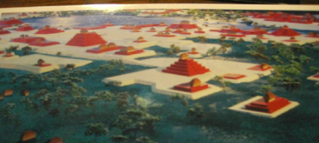
33. Therefore Moroni sent an army with their camp, to head the people of Morianton, to stop their flight into the land northward. 35. …they did not head them until they had come to [not in] the borders of the land Desolation: and there they did head them, by [near but not in] the narrow pass which led by the [west] sea into the land northward, yea, by the sea on the west … Nowhere in the Book of Mormon does it associate the land Desolation with the east sea or the north sea. The only sea ever directly associated with the land/city Desolation is the west sea. If the “sea on the west” was the same as the Gulf of Mexico then the bodies of the dead Lamanites would have to have been carried over 30 miles from San Lorenzo/Desolation to be dumped into the “sea on the west” being the Gulf of Mexico. I do not believe the Book of Mormon supports such a proposition. Also note that if Dzibanche was the city Bountiful and if they had traveled southward along the Gulf of Mexico (the sea on the west) then they would have been traveling southward to get to the land northward. How does that make any sense?
Moroni’s objective was to stop Morianton’s flight into the Jaredite land northward. They were successful and stopped them just before they got to the narrow pass that led by the west sea into the land Desolation, right at the “line.” Land Desolation began on the west sea. San Lorenzo was located in the middle of the Olmec heartland (the Jaredite land northward). Therefore, the San Lorenzo area as the city of Desolation cannot be correct.36
The Allens claim that the term the “sea on the west” refers to the west side of the Yucatan Peninsula. Therefore, they reason, Morianton was headed “by the sea on the west” near the Coatzacoalcos River which would have been the Jaredite north sea and not the west sea. Another question that must be asked is, where was the narrow pass located that bordered the Gulf of Mexico that also led by the west sea northward into the Jaredite land northward?37
The Book of Mormon does not allow for two different west seas. The sea that was “in the borders west (of Zarahemla) by the seashore” must be the same west sea that bordered the land Desolation where the narrow pass was located that “led by the [west] sea into the land northward, yea by the sea on the west”. Therefore, Joshua must have been located on the Pacific coast.
WHY WAS JOSHUA BEING LOCATED IN THE PACIFIC CORRIDOR SO IMPORTANT?
Joshua was very important in the lives of Mormon and Moroni. Let us briefly review. Mormon was carried by his father (following Stoddard’s pacific coastal route, “the only reasonable route”) from the Jaredite land northward to the city of Zarahemla at age 11 (AD 322). At age 15 he became general of the Nephite armies at the city of Zarahemla. When he was 16, the Nephites feared the Lamanite/Gadianton armies so much that they fled (with their families) to Angola where they set up defenses but did not prevail. They fled to David and then they fled west to Joshua located by the west seashore where Mormon brought his people together and raised an army of 42,000. Mormon defeated the Lamanite/Gadianton army of 44,000 at Joshua at the end of the year AD 330. These events took place over a period of less than 3 years. The Lamanites and robbers then controlled all of the land of Zarahemla, the narrow strip of wilderness, and the land of Nephi from the east sea to the west sea, except for Joshua and northward from Joshua (the west-sea land Bountiful). Mormon resided in the area of Joshua for a total of about 17 years until AD 345. I believe it was in the Joshua area that Moroni was reared and from where he was sent on his mission (Moroni 8:1), presumably to the Jaredite land northward, as there was no other place where the Nephites were located except Joshua and northward along the Pacific Corridor into the Jaredite land northward.
In the year AD 345 the Lamanites gained the upper hand and sent the Nephites fleeing from Joshua northward “even to the land of Jashon, before it was possible for Mormon to stop them in their retreat (Mormon2:16).” This Jashon/Jordan/hill Shim area38 (within the Jaredite land northward, probably near the Chivela pass) is where they paused briefly while Mormon retrieved the plates of Nephi from the hill Shim, leaving the remainder of the records as instructed by Ammaron. Apparently he did not fear losing the remaining records at that time. Within that same year, AD 345, the Lamanites came again against the Nephites at Jashon/Jordan and they fled “northward” from Jashon/Jordan to Shem where Mormon established a defense (Mormon 2:20).
The next year, AD 346, Mormon amassed an army of 30,000 at Shem and beat the Lamanite army of 50,000. Not only did he beat them but within three years Mormon recovered all the lands they had lost, or, in the words of the Book of Mormon, “had again taken possession of the lands of our inheritance” in the year AD 349 (Mormon 2:27). This must have included chasing the Lamanites southward from Shem to Jashon/Jordan and then farther southward to (the future city) Desolation area and the west sea and then even farther southward at least to Joshua on the west sea coast. Notice that they did not go northward from Shem toward the Gulf of Mexico where Exploring places the cities of Jashon/Jordon and Desolation and the hill Shim all about 30 miles from the Gulf of Mexico.39
Mormon chased the Lamanites southward from Shem, retaking all the lands they had lost, all the way southward to at least Joshua on the west sea coast near Izapa. Because they had fled from (and had abandoned the cities of) Zarahemla, Angola, and David (all in the land southward) and because they had not been there for more than 18 years then they probably did not count those cities as part of their inheritance any longer. Certainly the area of Joshua, which they had just recently lost, was recovered.40 Mormon was residing at least in Joshua on the west sea coast at the time that he entered into the AD 350 treaty. If he had not been in possession of some of the land southward then how could he have given up any land southward of the line between Desolation and Bountiful? If Joshua was located near the Gulf of Mexico, as claimed by the Allens and Stoddard and Magleby, then Mormon would have been located in the Jaredite land northward and he could not have given up any of the land southward. This is another factor indicating that Joshua had to have been located south of the “line” and not at Tonala which is located north of the “line.”
CONCLUSION
There can be no doubt the cities of Angola, David and Joshua were located in the land southward, and therefore, could not have been located near the Coatzacoalcos River or the Gulf of Mexico. In the AD 350 treaty the Nephites gave up the areas of Joshua, and the west-sea land Bountiful to the “line” between Bountiful and Desolation. It is also interesting to note that this area of Joshua/Izapa is the southernmost boundary of the Epi-Olmec culture (which included the Nephites until AD 400) which culture occupied all of the Isthmus of Tehuantepec and along the Pacific corridor to Izapa from about 100 BC to AD 500.41
Since Joshua was located on the Pacific coast south of the “line,” then city Desolation, Teancum, and Boaz and “the place where the sea divides the land” must have been located just north of the “line.” These locations bordered the Nephite west sea, (the Jaredite south sea) located at the Gulf of Tehuantepec and not at, or even near, the Gulf of Mexico.
The saga of the Nephites began on the west sea coast (The Pacific) west of the land of Nephi and just south of the narrow strip of wilderness somewhere near the area of Joshua/Izapa. This was their promised land where they landed. This was also part of the later described west-sea land Bountiful which the Nephites had occupied from the west sea to the east (Sierra Madre Mountains). This was the same area which Moroni and Helaman and his 2000 warriors so valiantly defended, “the west sea south.” 42 This is the same area where the “tree of Life” monument is located at the temple at Izapa. This temple is the temple that is identical to the size of Solomon’s temple times 15.43 This is the area where 2,500 righteous Lamanites and Nephites, including the prophet Nephi, gathered about a year after Christ’s crucifixion and witnessed his advent and resurrection in the Americas. It is also interesting to note that the temple at Izapa would have been central to all the Nephites and Lamanites living in the land southward and to the Nephites living in the Jaredite land northward during the more than 100 years of peace following Christ’s appearance in America. This was the last area given up by the Nephites in the land southward pursuant to the AD 350 treaty.
I believe that this area near Joshua/Izapa was where the Nephite history began, and where the most important event in the history of the world was first witnessed in the Americas. This is also where the final chapter of the Nephite existence in the Americas began. This is why the Joshua/Izapa area, being located on the west coast, was so important. It was not located near the Gulf of Mexico or the Gulf of Tehuantepec but south of the “treaty Line” near Izapa on the Pacific coast.
Notes:
1. See my article at BMAF entitled Usumacinta River is the River Sidon.
2. See Richard Hauck’s BMAF presentationgiven on February 26, 2010 in Salama, Guatemala.
3. See Book of Mormon Resources, map 4 of 35. One cannot stand on the Chuacus Mountain (Magleby’s proposed hill north of Shilom, 30 miles distance) and see anything in Guatemala City/Nephi/Kaminaljuyu! This is in contravention of the Book of Mormon. Ammon could look down and see the people in Shilom. The people in Nephi could look up and see Noah’s tower on the hill north of Shilom. King Mosiah I had his people congregate on the hill north of Shilom before crossing the narrow strip of wilderness. The hill north of Shilom could not have been located 30 miles away from Kaminaljuyu, elevation 5000 ft. Mosiah would have to have gone down into very rough and steep terrain 20 miles to the Motagua River (elevation 2000 ft) and then up the very roughed terrain to the top of Chuacus mountains (elevation 6000 ft) another 10 miles or so. How does that make any sense at all? (See also my article entitled
Usumacinta River is the River Sidon at BMAF.org.)4. See my article at BMAF entitled Usumacinta River is the River Sidon. This article gives many reasons why
Kaminaljuyu could not have been the city of Nephi. See appendix A for a summary of 6 of those reasons.
5. See my article located at BMAF entitled Why City Bountiful was not Located in the Yucatan, the Peten or Northern Belize
6 Helaman 6:3-9 “3…they did have fellowship one with another…4….the Lamanites did come down into the land of Zarahemla…and did exhort them to faith and repentance 8….the Lamanites did also go whithersoever they would, whether among the Lamanites or among the Nephites; and thus they did have free intercourse one with another to buy and to sell and to get gain according to their desire.” There should be no doubt that when It talks about the Lamanites between the years 30 BC to AD 34, unless specifically stated otherwise, it is talking about the Lamanites living in the land of Nephi south of the narrow strip of wilderness.
7. Helaman 5:14-15 States “14…they went forth, keeping the commandments of God, to teach the word of God among all the people of Nephi, beginning at the city Bountiful; 15 and from thenceforth [southward] to the city of Gid; and from the city of Gid to the city of Mulek; 16. And even from one city to another, until they had gone forth among all the people of Nephi who were in the land southward; and from thence into the land [/city] of Zarahemla, among the Lamanites [living in the Zarahemla area]. 20. …Nephi and Lehi did proceed from thence to go to the land of Nephi. [Therefore the land northward of the city Bountiful was not part of the Nephite land southward. It also proves that there was a different land Bountiful located at the “line” on the west sea because all of the Jaredite land northward (where many Nephites had migrated) was located northward of the west-sea land Bountiful and not northward from east-sea city Bountiful].
8. Alma 46:7 7 And there were many in the church who believed in the flattering words of Amalickiah, therefore they dissented even from the church; and thus were the affairs of the people of Nephi exceedingly precarious and dangerous, notwithstanding their great victory which they had had over the Lamanites, and their great rejoicings which they had had because of their deliverance by the hand of the Lord.
9 . See Deciphering at page 31-33. Also see my article located at BMAF entitled Three Separate Lands Bountiful. Where Located? What size? To which Bountiful did Christ appear?
10. Until about AD 345 the Book of Mormon only mentions the Jaredite land northward regarding the following events: (a) Limhi’s scouts traveled to the Jaredite land northward in search of Zarahemla but returned believing Zarahemla had been destroyed; (b) About 55 BC Hagoth took ships into the Hagoth land northward (not the Jaredite land northward) but no mention of where; (c) Beginning about 72 BC and specifically about 46 BC, a migration took place of Nephites and Lamanites moving into the Jaredite land northward but the Book of Mormon does not follow them. (d) In 29-23 BC Nephi and Lehi served an unsuccessful six year mission in the Jaredite land northward but the Book of Mormon does not explain or elaborate, only that they could not stay there; (e) In 68 BC Morianton attempted to flee to the Jaredite land northward but did not make it; (f) About AD 17, Lachoneus took the righteous Lamanites and Nephites to reside 7 years near, but not in, the borders of the Jaredite land northward. He did not go into it; (g) About AD 321 Mormon’s father took young Mormon from the Jaredite land northward into the city of Zarahemla; (h) and then AD 345 the Lamanites/Gadianton robbers chased most of the surviving Nephites into the Jaredite land northward. The Gadianton Robbers did not come from the Jaredite land northward but from the land southward.
11. See my article located at BMAF entitled Geography of the Gadianton Robbers.
12. See my response to Ted Stoddard’s Lowland Maya article, entitled Response to Stoddard’s “Maya Problem” located at BMAF.org.
13. See my article located at BMAF entitled City Desolation could not have been San Lorenzo or near the Gulf of Mexico.
14. See my article at BMAF entitled Three Lands Northward: Where Located? How large?
15. See my article entitled Three Lands Northward: Where Located? How large? Located at BMAF.org.
16. Helaman 7:3
and Helaman 3:16 which says that these Nephites and Lamanites in the Jaredite land northward had fallen into such transgression that they "...are no more called the Nephites , becoming wicked, and wild, and ferocious, yea, even becoming Lamanites."
17. See my article entitled Why City Lib cannot be La Venta or anywhere near the Gulf of Mexico at BMAF.org The following map proposes a more likely area that was nearly surrounded by water (the areas in green and orange).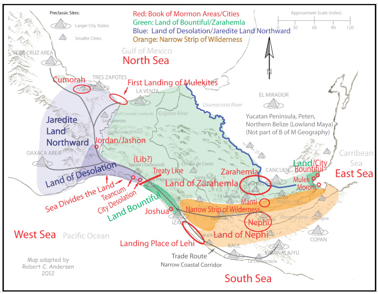
18. See Deciphering at page 188.
19. Ibid at page 12-13.
20. See Exploring at pages 552 & 629.
21.
See my article located at BMAF.org entitled Why city Lib was Not Located at La Venta or anywhere Near the Gulf of Mexico. Note also that the “line,” and Bountiful, and Desolation are always directly associated only with the west sea.
|
Alma 63:5 5 And it came to pass that Hagoth, he being an exceedingly curious man, therefore he went forth and built him an exceedingly large ship, on the borders of [in] the land Bountiful [south of the “line”] by [close but not in] the land Desolation [north of the “line”], and launched it forth into the west sea, by [close to but not in] the narrow neck which led into the land northward. [The Jaredite land northward included the entire Isthmus of Tehuantepec. This narrow neck started at the “line” and went by the west sea into the Jaredite land northward. This same narrow neck of land (pass) started at the same “line” and went by the west sea into the land southward (Bountiful) See also Mormon 2:29 and 3:5].
Ether 10:20 20 And they built a great city by [near but not in] the narrow neck of land, [which led into the land southward (Bountiful)]by the place where the sea divides the land. [This city must have been built just north of the “Line” between Bountiful and Desolation because all of the land southward was preserved as a wilderness to get game” and it was all the land north of the “line” that was populated by the Jaredites. Therefore, the "sea that divides the land” had to have been the Nephite west sea or the Jaredite south sea].
|
22 . The land found by the scouts of Limhi was probably not the Hill Cumorah area. These scouts found a land with “dry bones” (See Mosiah 21:26) and in a “land of many waters” ( See Mosiah 8:8). This appears to me to be a different land than Cumorah which is described as in a “land of many waters, rivers, and fountains.” The main difference to me seems to be that here were dry bones found by the scouts. The proposed land of Cumorah is in a land with over 200 inches of rain per year where there could not have been and “dry bones” on the surface of the land some 100 plus years after the final Jaredite battle. Whereas the area of the Gulf of Tehuantepec receives only about 40 plus inches of rain per year and for much of the year it is very dry except along the rivers that drain from the Sierra Madre Mountains in the center of the land.
23. See Deciphering at page 92.
24. See my article located at BMAF.org entitled Why City Desolation could not have been Located near the Gulf of Mexico.
25. See Deciphering at pages 84-89.
26. See Garth Norman’s study map 2005.
27. See Deciphering at page 150.
28. Exploring at page 395 states “We learn the names of some Nephite occupied cities after the AD 350 treaty with the Lamanites. These cities were located in the land northward near the narrow neck of land. Perhaps a couple of these cities extended south, near to the Gulf of Tehuantepec. Most, however, were probably on the Gulf of Mexico side in the present day states of Veracruz and Tabasco. These include the cities of Desolation, Boaz, Teancum, Shem, Jashon, Joshua, Angola, and David all of which were probably in the land Desolation (land northward)” This is clearly mistaken as the cities of Joshua, Angola, and David are discussed in the year 329 when Mormon and the Nephites were permanently chased out of the city of Zarahemla. Mormon finally located and lived in Joshua, near the Pacific coast south of the “line” between Bountiful and Desolation, for about 17 years.
29. See Exploring at page 395 and 552.
30. See Magleby’s Book of Mormon Resources map on the Home page.
31. See Exploring at pages 393, 400, and 414.
32. An E-mail sent me 11-18-10 wherein Dr. Allen clarified, stating:
"We thank you for calling our attention to this paragraph because we DO NOT believe that the Gulf of Mexico and the Coatzacoalcos River together form the “place where the sea divides the land.” The word “obvious” in this paragraph is not intended to proclaim that the Coatzacoalcos River and the Gulf of Mexico together are the obvious location of the “place where the sea divides the land.” We were trying to convey the concept that the descriptions outlined in Ether 10:20 “obviously” refer to a gulf and an isthmus.
In summary, we do not believe that the Coatzacoalcos River is part of the Gulf of Mexico…. We would appreciate it if you would make it clear that we believe that the “place where the sea divides the land” is only the Gulf of Mexico as reflected on our maps in figures 11-5, 19-12, 23-23, 26-1, 26-3, 26-22, as well as in other statements in Exploring the Lands of the Book of Mormon."
33. Moroni did not conquer this city of El Mirador ca 72 BC. This was the center of a huge complex of about 27 cities encompassing more than a million Maya. This was not part of the land of Zarahemla. It was not part of the Nephite land southward. The pyramid La Danta, upper right corner, is the largest and highest pyramid in the world, built about 300 BC many years before there was a designated land northward/land southward.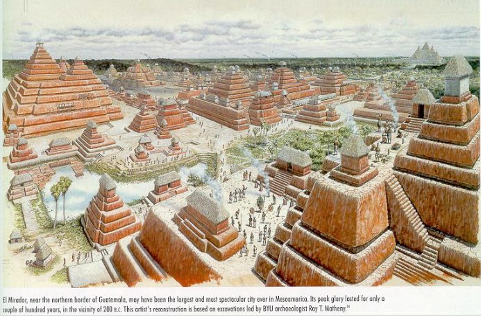
34. Ted Stoddard explained this so very well in an Email he sent to me August 2, 2010: For centuries, the only reasonable way to get from Chiapas or Guatemala to Veracruz, Oaxaca, or the Mexico valley was to end up on the Pacific coast and go north through the Isthmus of Tehuantepec. A about Fifty miles into the isthmus, the topography opens up, permitting travelers to continue to Veracruz or to follow trails into the mountains and thence to the Oaxaca or Mexico areas.
In a similar vein, travelers from the east wilderness (lowland jungle area of the Peten and Belize) or from the east sea (Caribbean off the coast of Belize) could not travel due west to go through the top of the isthmus because of (1) the mountainous terrain, especially in the Hermounts region at the top of and east of the isthmus, or (2) the marshy lagoons and rivers of Tabasco that made east-west travel almost impossible until the arrival of modern highways.
35. Exploring at page 622.
36. See my article located at BMAF.org entitled Why City Desolation could not have been Located near the Gulf of Mexico.
37.
38. [Jashon/Jordan]. [In Joseph Smith’s manuscript the word used was Jashon not Jordon. There was a transliteration error in the printer’s manuscript (See Royal Skousen’s article entitled Piecing together the original Manuscript located in the May 1992 issue of BYU Today)].
39. See Exploring at page 457.
40. Deciphering at page 186.
41. See my article at BMAF.org entitled Nephites and the Epi-Olmec.
42. Alma 53:22 And now it came to pass that Helaman did march at the head of his two thousand stripling soldiers, to the support of the people in the borders of the land on the south by the west sea.
Alma 53:8 And now it came to pass that the armies of the Lamanites, on the west sea, south, while in the absence of Moroni on account of some intrigue amongst the Nephites, which caused dissensions amongst them, had gained some ground over the Nephites, yea, insomuch that they had obtained possession of a number of their cities in that part of the land.
43. Personal communication with F. Richard Hauck, 2009.
If the answer to any one of the following questions is “no,” then, according to the Book of Mormon, that would mean that Kaminaljuyu could not have been the city of Nephi.
1. Is there a “hill north of Shilom” visible from Kaminaljuyu (Mosiah 11:1-13 7:3-15)?
No. This is evidenced by the following two maps:
1. (a) The first is a topographical relief map showing the Kaminaljuyu plateau (5000 ft..in elevation) in brown. The light color shows the ravines and areas below 5,000 ft. The green area shows the mountains to the west and southeast, however, to the north there is not even a small hill that rises above the elevation of about 5,150 ft. at Kaminaljuyu.
(b) Next is a cross-section of the actual elevations from the Pacific coast northward through Kaminaljuyu, then northward through the Salama valley, then through the Santa Cruz Mountains, and then down to the Usumacinta River. Notice on the high plateau where Kaminaljuyu is located there are no hills higher than the plateau northward from Kaminaljuyu (Guatemala City).
There is no hill or mountain higher and northward from Kaminaljuyu for more than 30 miles. The narrow strip of mountainous wilderness is not visible from Kaminaljuyu until one comes to the Chuacus mountain range some 30 miles away. One cannot see Kaminaljuyu from this mountain. (Used with permission of ARI)
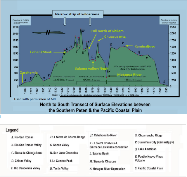
2. Can one see the Cuchumatanes/Santa Cruz Mountains from Kaminaljuyu?
No The 6000 ft. Chuacus Mountain prohibits one from seeing the narrow strip of wilderness from Kaminaljuyu. The distance of about 50 or more air miles from Kaminaljuyu also limits the visibility of this range of mountains.
3. Is Kaminaljuyu located about midway between the east and west seas as required by the Book of Mormon? No Kaminaljuyu is located about 60 air miles from the Pacific and about 140 miles from the Gulf of Honduras.
4. Did Kaminaljuyu have Preclassic defensive walls around it as required by the Book of Mormon (Mosiah:6-8)? No Kaminaljuyu was the dominant culture and had no need to have defensive walls. From about 1500 BC this community was in the process of expanding its borders, taking prisoners, and enslaving or killing the conquered leaders (AuthenticMaya.com).
5. Was there a late Preclassic ruin (Shilom) about one mile or so north from Kaminaljuyu that had defensive walls around it as required by the Book of Mormon (Mosiah 9:6-8 &7:3-15)?
No There is no evidence of a late Preclassic ruin or city of Shilom located about 2 miles north of Kaminaljuyu containing evidence of a defensive wall around it.
6. Was Kaminaljuyu a safe place for Nephi to have taken his family about 585 BC?
No The heavy population of the area of Kaminaljuyu (about 30,000 by about 585 BC) precluded it from being the city of Nephi. Expanding on the answer to question number 6:
What did Kaminaljuyu look like when Nephi landed about the year 588 BC? This artist's illustration below shows what the beautiful city of Kaminaljuyu probably looked like about the time Lehi landed in the Promised Land. About 30,000 people inhabited the area at the time.
The settlement at Kaminaljuyu started about 1500 BC. By about 750 BC Lake Miraflores had been developed, and temples were being built around it. It had an extensive irrigation system and farm lands in place. It was constantly expanding its borders, sacrificing the conquered leaders and using slaves to build their large adobe-type structures. By about 580 BC Kaminaljuyu had become one of the largest Preclassic city/states in Central America with only El Mirador and the Olmec heartland larger in size (AuthenticMaya.com).
Can you imagine Nephi walking into Kaminaljuyu with his 4 men, 5 or 6 women, and about 20 children under the age of 12 (2 Nephi 5:6)? Taking over Kaminaljuyu? Becoming “King of Nephi” (Jacob 1:15-16)? Building a temple after the manner of Solomon’s Temple (2Nephi 5:16)? Making all the 30,000 Maya live the law of Moses? Making Jacob and Joseph “priests and teachers over the land of Kaminaljuyu (2 Nephi 5:26)? And within 30 years be one big happy family of 30,000 Nephites (2 Nephi 5:27)?
No. This scenario would not have been possible. He did not have the manpower, capacity or disposition to conquer the city/state of Kaminaljuyu and become king. It would not have been a safe place for Nephi and his family to have settled.
The earthquakes of AD 34 were probably exclusively along the Chixoy Fault, just north and south of the narrow strip of wilderness.
When Christ was crucified and the discussions were taking place about the destruction in “the land,” it was talking about the destruction that occurred in the lands north and south of the narrow strip of wilderness. It was not talking about the Jaredite land northward. How could the Nephites and Lamanites have known about the destruction in the land northward? This is confirmed by carefully reading chapters 8 and 9 of third Nephi.
The destruction initially pointed out by the Lord was in the area of the greatest destruction; the city of Zarahemla was burned, the city of Moroni was sunk into the sea, and the city Moronihah was buried with earth and a great mountain was raise up in its place (see 3 Nephi 8:8-10 & 9:3-5). The greatest and most terrible destruction took place in the land northward of the narrow strip of wilderness. It was not in the Jaredite land northward because the cities of Zarahemla, Moroni, and Moronihah were not located in the Jaredite land northward. And the greatest destruction was not in the land south of the narrow strip of wilderness either. In 3 Nephi 8:11 it states:
|
11. And there was [also] a great and terrible destruction in the land southward [of the narrow strip of wilderness]. 12. But behold there was a more great and terrible destruction in the land northward [of the narrow strip of wilderness], for behold the whole face of the land [northward of the narrow strip of wilderness] was changed because of the tempest and the whirlwinds, and thundering and the lightnings, and the exceedingly great quaking of the whole earth. |
There is nothing in the Book of Mormon, or archeologically, that indicates that the area of the Jaredite land northward (the Isthmus of Tehuantepec), or the area north of the Isthmus of Tehuantepec, suffered substantially more damage than the land southward from the Isthmus of Tehuantepec about 34 AD.
Notice that the term “whole earth” here could not have included China but clearly it meant the whole area being discussed in verse 12 being the land northward of the narrow strip of wilderness. The land southward of the narrow strip of wilderness is likewise not included in verse 12 as being part of the “whole earth” that was so completely devastated because it was declared to have suffered less damage. There is no archeological evidence of such a massive destruction in the Isthmus area about AD 34 or any time for that matter. The Isthmus of Tehuantepec is not in an area of extensive earthquake and volcanic activities. Neither is the area of the Peten and the Yucatan or Belize. However the entire area of the narrow strip of wilderness is located directly on the Chixoy fault line.