


The Geography of the Jaredites
The Geography of the Jaredites
While the debate still burns as to where in Mesoamerica the Nephites and Lamanites resided, few have attempted to create and identify an internal map of the geography of the Jaredites. Although the body of work that is dedicated to the history and account of the Jaredite people is only a fraction of the overall text of the Book of Mormon, cardinal directions, descriptions of specific locations, and references to Nephite locations are used throughout the brief body of work. These specific mentions of the geography, which may seem minute with a casual read, cumulatively amount to an internal map of the Jaredite people. Further, because the geography of the Jaredites corresponds with some Nephite locations, the internal map can reasonably be placed in Central America near the previously proposed Nephite location. By constructing an internal map and identifying a probable physical location of the Kingdom of the descendants of the Jaredites, it follows that archeological evidence should be able to relatively identify a possible descendant culture of the Jaredite people.
From the geographical evidence within the text of the Book of Ether, I will systematically examine the above claims through a careful reading of the terminology and events of the Jaredites. It is first and foremost my highest priority to remain true to the intentions and authenticity of the Book of Mormon. With this said, it is necessary to establish a language to analyze the text. I will start the analysis in Part I by establishing the definitions I used to analyze the geography of the Jaredites and touch on some of the important relevant historical background within the Book of Ether before exploring the main focus of this article as follows:
Part II: Creating a basic combined Nephite/Jaredite internal map
Part III: Establishing an expanded internal map of the geography of the Jaredites
Part IV: Placing the internal maps within Mesoamerica
By connecting the landmarks between the Nephites and Jaredites, a more concise map of the geography and locations of the Book of Mormon lands can be established.
Part I
It is important to note that the Book of Ether is an abridgement of an abridgement and thus may explain what can be considered as limited geographic descriptions within the account as compared to the rest of the Book of Mormon. The Book of Ether is mainly a history of the descendants of Jared. Many times during the Book of Ether there existed at least 2 kingdoms, but Ether and the writers before him only recorded the events central to those loyal to the rule of the posterity of Jared and perhaps the brother of Jared1. The history of the expansion and contraction of the kingdom ebbs and flows as much as the tides on the seashores that surround the area. In the end, Ether observes and records the destruction of the entire kingdom and fulfillment of prophecy.
After 344 days at sea, the brother of Jared and approximately 22 other adults were led to the “Land of their inheritance” and landed on “the shore of the promised land” (Ether 5:12) and started their kingdom. Four times the term seashore is used in Ether, and in each occasion it references a sea as in ocean and not a lakeshore or river shoreline. This conclusion is initially established as the family expresses gratitude for not encountering any whales or sea monsters during their travels (Ether 5:10). Whales and sea monsters would only be present in an ocean and not a lake or any other freshwater body. Since the only time the word shore is used is in reference to the sea or as part of the word seashore, I conclude that the context and use of the word is consistent throughout the scriptures and thus refers to the ocean. In comparison Ripliancum, which is considered the largest body of water (Ether 15:8), is called “waters of Ripliancum” instead of seashore. The special designation of the waters of Ripliancum as large in comparison to others indicates that the overall size must have been ascertainable in some way and not endless, as the ocean would appear. It is from this distinction that I determine the use of seashore to specifically mean the shore of an ocean.
Just before Jared and his brother died they counted all their people. The brother of Jared had 22 children and Jared had 12 (Ether 6:20). If the other 11 couples also had an average of 17 children, then there would have been about 200 children and many grandchildren by the time Jared and his brother died approximately 50 years after landing2. This exponential increase in
population illustrates how the Jaredites and also the descendants of the other eleven couples could have quickly populated many areas and established many cities (and perhaps several independent cultures) by about 2000 BC.
Moron was the first city and kingdom established in the Land of Promise under the reign of Orihah, son of Jared, around 2100 BC3 and was continuously occupied during the reign of the Jaredites. As the site of the first kingdom and the place “where the king dwelt” (Ether 7:5), the phrase the kingdom refers to the physical land of Moron and surrounding cities that fall under Jaredite reign. The precedence for such an interpretation is established in Ether 7:9 when Ephraim fought against his brother Corihor, “…And after he had armed them with swords he returned to the city Nehor and gave battle unto his brother Corihor, by which means he obtained the kingdom and restored it unto his father Kib.” Kib had previously been king of Moron until his son usurped his power and dethroned him. For all other instances when Moron is not the intended kingdom, the scriptures specifically state the title of the alternate kingdom as in Ether 7:20 where it specifies “the kingdom of Cohor,” or sometimes it states “half of the Kingdom.”
The references to the Nephite lands within the record of the Jaredites provide many key locations that help construct an internal Jaredite map. Many of the same geographical markers are used within the narrative of the Jaredites and the Nephites/Mulekites/Lamanites narrative, thus it is necessary to understand the physical locations of these landmarks relative to each other. The following is a list of all the intersections of the geography of the Jaredites and the people throughout the rest of the Book of Mormon. In all of these instances the geographic location exists in both time periods, providing the necessary information in establishing a link between the timeline and geography of the two periods.
1. The Jaredite hill Ramah and the Nephite hill Cumorah were the same hill (Ether 15:11).
2. Hill Shim (place where Ammoron hid the Nephite records) was “passed by” by Omer when he fled Moron and traveled many days (Ether 9:3).
3. The Land and city Desolation were located in the land northward and northward of and adjacent to the Nephite west sea land Bountiful, which was located within the land southward (Andersen4).
4. Ramah/Cumorah was located northward of Desolation and Moron
5. Moron was located near but not in the land Desolation (Ether 7:6). The land Desolation was located adjacent to Bountiful, which was part of the land southward (Alma 22:30-32).
6. There was a small neck of land that included the “line” and divided the land northward (Jaredite) from the land southward (Nephite) (Alma 22:32).
7. King Lib resided in Moron about 800 to 900 BC. This was about the same time the serpent plague was removed, permitting hunting in the land Bountiful (Alma 22:31) and perhaps in other parts of the land southward (Ether 10:19).
8. King Lib built a new city near the entrance into the land southward to preserve Bountiful as the hunting area for loyal subjects, for food, and commerce (Ether 10:21-22).
9. City “Lib” must have been near the west sea land Bountiful (Ether 10:20-21 & Alma 22:31), near the Nephite west sea (Ether 10:19 & Alma 32:31), near a place where the Nephite west sea divided the land, and near the narrow neck of land leading by the west sea into the lands northward/southward (Ether 10:19-21 & Alma 63:5).
10. In 345 AD Mormon fled Joshua (Mormon 2:16) into the land northward to Jashon, near hill Shim, then northward to city Shem, and then eventually back to Joshua in the land southward (Mormon 2:27).5
11. Coriantumr, the last survivor of the final Jaredite civil war (about 300 BC), lived “nine moons” in Zarahemla (Omni 1:20-22).
12. The Jaredite land Northward was the same as the Nephite north country (Hel 4:7-8, Hel 6:8, Hel 7:1, Hel 3:3-12, Omni 1:22).
The information above establishes that the land of the Jaredites overlaps in some areas with the land of the Nephites. Not only were the two groups initially separated by 1500 years and led to the same promised land, but they were also led to the same general area. This means that the maps that Book of Mormon scholars have determined as likely geographic matches previously can also be used to determine the whereabouts of the Jaredites. We can now develop a map based on our understanding of the placement of locations in the rest of the book of Mormon to determine the position of the overlapping Jaredite sites.
The first step in determining the succinct placement of landmarks between the Jaredites and Nephites is understanding the placement of seas surrounding the land. The following scriptures show the relationship between the Nephite east and west seas and the Jaredite south and north seas and how the lands in between are connected according to the Book of Mormon.
As of 90 BC, the Land of Nephi and the land of Zarahemla were divided by a narrow strip of mountainous (Andersen)6 wilderness that extended to the east and west seas with the Land of Nephi south of the wilderness and the land of Zarahemla north of the wilderness,
.…[the Lamanite lands] …were in all the regions round about, which was bordering even to the sea, on the east and on the west, and which was divided from the land of Zarahemla by a narrow strip of wilderness, which ran from the sea east even to the sea west…and thus were the Lamanites and the Nephites divided. (Alma 22:27)
Both the land of Nephi (south of the wilderness) and the land of Zarahemla (north of the wilderness) extended from the same east sea to the same west sea. Some Lamanites lived near the place where Lehi and his sons first arrived along the same sea that bordered west of the land of Nephi, ….[Some Lamanites lived in the narrow strip of wilderness] on the west in the land of Nephi, in the place of their fathers’ first inheritance, and thus bordering along by the seashore…(Alma 22:28).
The “place of their fathers’ first inheritance” refers to the location of Lehi’s arrival on the promised land. He landed on the west seacoast, which was west of the land of Nephi in about 588 BC (1 Nephi 18:23) and called it the promised land.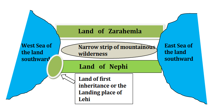
The Nephites possessed all of the land northward from the narrow strip of wilderness, which specifically included all the land bordering on the west sea land Bountiful until it came northward to the line between Bountiful and Desolation.
29…the Nephites had taken possession of all the northern parts of the land bordering on the [narrow strip of] wilderness…from the east to the west, round about on the wilderness side; on the north, even until they came to the land which they called Bountiful.
30. And it bordered upon the land which they called Desolation, it being so far northward that it came into the land which had been peopled and been destroyed. (Alma 22:29-30)
West sea land Bountiful bordered Desolation and Desolation extended into the land northward where the Jaredites had been destroyed. West sea land Bountiful is the same area where all of the animals fled when the poisonous serpents and drought depleted the land northward.
31. …and thus the land on the northward [from the line] was called Desolation, and the land on the southward [from the line] was called Bountiful, it being the wilderness which is filled with all manner of wild animals of every kind, a part of which had come from the land northward for food. (Alma 22:31). A key part to understanding these verses is in understanding the pronouns that determine the relationship between the different lands. It, or the wilderness, refers to the land southward, which was called Bountiful. The line between Bountiful and Desolation that was owned by the Nephites separated these two places.
32 …it was only the distance of a day and a half’s journey for a Nephite, on the line Bountiful and the land Desolation, from the east to the west sea;…
Narrow strip of mountainous wilderness
Land of Nephi
Land of Zarahemla
Land of first inheritance or the Landing place of Lehi
West Sea of the land southward
East Sea of the land southward
33…Thus the land on the northward was called Desolation, and the land on the southward was called Bountiful…(Alma 22:29-33)
It is important to note that the distance from the “east to the west sea” is only a day and a half. This means that a Nephite would have been able to complete the journey from an eastern point to the west sea in the specified amount of time.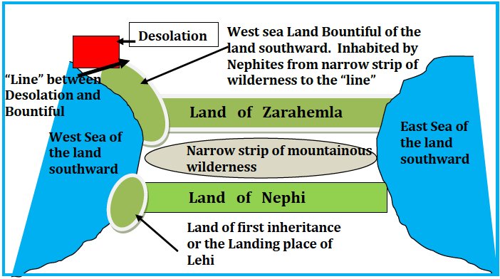
The length of the line from the east to the west sea was the same as the distance across the narrow neck of land that led from the land Bountiful into the land northward. The length of this defensive line was only about 12-20 miles7. Therefore, Bountiful was located adjacent to the west sea, hereafter called the west sea land Bountiful. West sea land Bountiful was located north of the narrow strip of wilderness and bordered on the west sea until it came to the “line” between Bountiful and desolation hereafter denoted line. Desolation was located northward from the line and was part of the land northward. It also bordered the same west sea where the line started. Desolation then went northward from that line until it came into the land where the Jaredites were summarily destroyed.
7 The Allens postulate this to have been about 12 miles (Exploring the Lands of the Book of Mormon, 119).
Narrow strip of mountainous wilderness
Land of Nephi
Land of Zarahemla
Land of first inheritance or the Landing place of Lehi
West Sea of the land southward
“Line” between Desolation and Bountiful
West sea Land Bountiful of the land southward. Inhabited by Nephites from narrow strip of wilderness to the “line”
Desolation
East Sea of the land southward
8
By 72 BC the Nephites possessed all of the land northward from the narrow strip of wilderness and had started to possess the Jaredite land northward including the land of Desolation. By 46 BC these migrations were accelerating:
3 An exceedingly great many…departed out of the land of Zarahemla. And went forth unto the land northward to inherit the land.
8.…They did multiply and spread, and did go forth from the land southward to the land northward, and did spread insomuch that they began to cover the face of the whole earth, from the sea south to the sea north, from the sea west to the sea east. (Hel 3:3,8)
The “sea south and sea north” references the Jaredite lands...The Nephites eventually populated all the Jaredite land northward from the line between Bountiful and Desolation northward from the Jaredite south sea to the Jaredite north sea.
All of these scriptures help in adding to the description of the topography of the land. The west sea land Bountiful bordered the west sea, extended northward from the narrow strip of wilderness, and was located south from and adjacent to Desolation. Desolation was located on the southern part of the land northward and bordered the same Nephite west sea. The land northward extended from the Jaredite south sea (from Desolation also located on the Nephite west sea) to the Jaredite North Sea. From these conclusions, the following internal map connects the land of the Jaredites with the land of the Nephite/Lamanites.
INTERNAL MAP OF LAND NORTHWARD AND LAND SOUTHWARD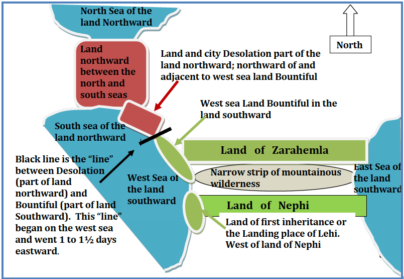
Part III
Establishing an expanded internal map of the geography of the Jaredites
Now that the outline for the overall geography of the two time periods has been established, it is possible to place the rest of the geographic descriptions throughout the book of Ether according to the locations shown on the following cohesive map. Through a careful reading of the Jaredite text, it is apparent that specific relationships between locations are established throughout the migration of battles and people that indicate requirements for many of the geographic locations mentioned in connection with the Jaredites, thus providing the information necessary to establish the regions geography.
We will start the analysis by identifying landmarks that are associated with Desolation and Bountiful and moving outward. Once we establish possible locations for the many sites mentioned in the book of Ether, then we can analyze the migration of battles and people from Moron to Ramah.
When Jared and the rest of his family first landed upon the shore, they deemed the area the promised land. The city of Moron was established as the place where the king of the land reigned, and Moron remained the principal capital city. Since Moron was the first city established, it is reasonable to surmise that the land of Moron is near the shore where Jared and his family first landed but also in a defensible position. Additionally, when Coriantumr chased Lib to Moron, Lib retreated to the seashore, illustrating that Moron is close enough to a seashore that the seashore would be the next natural line of defense (Ether 14:12-14). Moron was also located near Nephite-designated Desolation8 (Ether 7:6) in the Jaredite land Northward. Moron could not have been located south of the land Desolation because the Nephites designated that area as the land Southward, which included the land Bountiful. It is reasonable to suspect that Moron would have been located either northward or more likely southward from Desolation. The afore mentioned determination of Moron’s location and proximity relative to Desolation shows that the sea that bordered Desolation was most likely the same sea nearest Moron.
Nehor9 is the next city mentioned after the city of Moron. When Corihor rebelled against his father, the king, he “…went over and dwelt in the land of Nehor…” (Ether 7:4). Later when
8 See appendix B for information explaining why Desolation was east of Moron.
9 F. Richard Hauck proposes Nehor as the valley of Corihor in his book Deciphering the Geography of the Book of Mormon pg. 158. This could possibly have been the birthplace of the order of the Nehors as well.
10
Corihor desired to battle the king, it states, “…he came up unto the land of Moron where the king dwelt” (Ether 7:5). The use of went over creates a relational link between the two cities seeming to imply that they are close in proximity to one another. The use of came up implies another geographic relationship. Up denotes elevation. If Corihor had to go up from the land of Nehor, then Moron must be higher in elevation than Nehor. This same reasoning applies when understanding the location of the wilderness of Akish in relation to Moron. Coriantumr who was living in the wilderness with his army “came up unto the land of Moron, and gave battle unto Lib” (Ether 14:11). Again, the use of the word up shows that Moron was higher in elevation than the wilderness of Akish. Both of these examples support defense tactics that would have logically compelled the Jaredites to initially choose an area to settle that was higher in elevation than the surrounding areas. The vantage point would have made Moron easier to defend.
Chapter 9 sheds further light on the area of the Jaredites when King Omer had to flee from Moron:
…Wherefore Omer departed out of the land with his family, and traveled many days, and came over and passed by the hill of Shim, and came over by the place where the Nephites were destroyed, and from thence eastward, and came to a place which was called Ablom, by the seashore…. (Ether 9:3)
The fact that Omer had to travel many days with his family and then continue onward passing Cumorah and Shim, suggests that Ablom was not located near the same seashore as Moron. The above scripture also establishes that Ramah, which is the place where the Nephites were destroyed, is west of the sea near Ablom and thus north of Desolation. This is the only location in the book of Ether where the distance between two areas is quantified by a number of days. The distinction signifies that the location to which Omer took his family was a lot farther away from Moron than all the other locations mentioned in conjunction with Moron throughout the book of Ether.
When the Jaredite kingdom started to disintegrate into the destroying of people and land, the overall route took a circular but decidedly northern progression starting from the west of Moron in the valley of Gilgal where Coriantumr and Shared met to battle. Coriantumr left Moron to battle in the valley of Gilgal. After battling for three days, Coriantumr pursued Shared farther away from Moron, “And it came to pass that Coriantumr beat him, and did pursue him until he came to the plains of Heshlon” ( Ether 13: 28). From the plains of Heshlon Shared drove Coriantumr back to the valley of Gilgal (Ether 13: 29) where Coriantumr killed Shared but not before Coriantumr was wounded, and they suspended battle for two years. Then Gilead trapped Coriantumr in the wilderness of Akish for two years. Assuming that the scriptures mention all the locations that the troops would have crossed in pursuit of battle, then it is safe to say that the locations that are mentioned in relation to one another are in fact adjacent. This means that the valley of Gilgal is on the western side of Moron because Desolation is to the east and the sea to the south. It also implies that the plains of Heshlon are on the side of Gilgal opposite from Moron. If Heshlon was not on the side of Gilgal opposite of Moron, then it would have been possible for the battle to have progressed to Moron instead of back into Gilgal.
It is not until chapter 14 in the book of Ether that the extent of the Jaredite geography is fully illuminated due to the route of the numerous battles. During the first part of chapter 14 the wilderness of Akish becomes the geographic focal point as Coriantumr and Lib fight back and forth. Coriantumr builds up his army for two years in the wilderness of Akish and then attacks Lib in Moron (Ether 14:7,11). In chapter 14 in verses 12-14 the following route unfolds as the battle leaves Moron for the last time:
12…the armies of Coriantumr did press forward upon Lib, that he fled to the borders upon the seashore.
13 And it came to pass that Coriantumr pursued him; and Lib gave battle unto him upon the seashore.
14 And it came to pass that Lib did smite the army of Coriantumr that they fled again to the wilderness of Akish.
After Coriantumr and Lib leave Moron they battle on the seashore, which has previously been established as the same seashore that borders Desolation. From the seashore they go directly to the wilderness of Akish and continue to battle, thus the wilderness of Akish is located near the same seashore as Moron and Desolation. The fact that the route starts in the wilderness of Akish, moves to Moron, then to the seashore, and back again to the wilderness of Akish, demonstrates a triangular relationship with Moron and the wilderness of Akish adjacent to one another, forming the base, and the seashore forming the point of a triangle. In any case, the route depicted in the scriptures shows that all three locations can be accessed from any of those points making them relatively close together.
The battle leaves the wilderness of Akish and continues into the plains of Agosh, which I propose is located at least partially within the Nephite land of Desolation. Since the wilderness of Akish is located in between Moron and Desolation and the seashore is southerly, then the plains of Agosh could only have been located to the north, east, or some combination thereof from the wilderness of Akish. It is in the plains of Agosh that Coriantumr slays Lib and the war proceeds in a northerly direction from the Jaredite south sea towards an irreversible path of destruction.
With Shiz determined to avenge his brother’s death, Coriantumr flees from city to city and from “the shedding of blood to the shedding of blood” (Ether 14:22) until finally arriving at the north sea shore where a three-day battle ensued. Coriantumr gained the advantage and chased Shiz westward to the valley of Corihor. Coriantumr camped nearby in the valley of Shurr. Both of these valleys were located near a hill called Comnor. Hill Comnor must have been located near the vicinity of Ramah and Ripliancum because the war was entering its final phase and the major part of the population of the Jaredite people had already been killed and the inhabited areas decimated. Therefore, hill Comnor must have been located just southward and maybe even westward of Ramah/Cumorah. Three consecutive battles occurred on the hill Comnor and after the third one, Shiz prevailed. At this point Coriantumr stood amidst the destruction of over six million of his people and repents. Shiz then chased Coriantumr northward to Ripliancum and continued the battle that leads to the wounding of Coriantumr. Following the battle, Coriantumr’s army chased Shiz southward to Ogath, which was located near Ramah/Cumorah. About 14 years after the last civil war started at Moron, the final battle occurred near the hill Ramah/Cumorah wherein all the remaining Jaredites participating in that civil war were killed except Coriantumr.
The following is a proposed internal map of the Jaredite geography. It incorporates all of the above imperatives.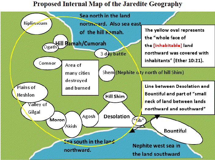
In the above map I have situated Ramah/Cumorah northward from Desolation and Moron, desolation eastward of Moron, and labeled the sea adjacent to the land of Moron as the Jaredite south, which is the same sea as the Nephite west sea. Some may question the exact directions and locations I used for these geographical points, but as seen from the analysis above, I have limited the locations to the relative and possible positions based on the scriptures. In section four, it will become more evident why I have chosen these specific placements.
I have also included a second version of the Jaredite geography this time indicating the northward progression in red that the final 14-year civil war, as described in Ether 13-15, followed.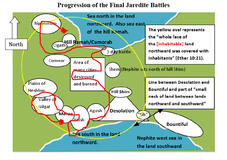
The red line shows the approximate route of the final 14-year war beginning at Moron and ending at Ramah/Cumorah about 300 BC. The war starts in the southern kingdom and follows a northward progression into the second kingdom until they are both destroyed. `
PART IV
Placing the internal maps within Mesoamerica
Even though the Jaredites started with a little more than a couple dozen adults, the long life span aided in the number of progeny, exponentially increasing the growth of the population. The population was greater than five million before the battle at Comnor, and this only accounts for the lineage of Jaredite and his brother. So where on earth, or more correctly, on the Western Hemisphere, is there any evidence of such a massive population that also had a written language having existed about 250 to 350 BC? The only place currently known is within the Olmec/early
North
15
Pre-classic Zapotec people of Southern Mexico. The Olmec heartland and surrounding areas meet all the requirements necessary to be the most likely and reasonable candidate for the Jaredite people. As far as I am aware, most of the Mesoamerican proponents are in agreement that the Olmec, or at least the Heartland Olmec were where the majority of Jaredites resided.
The following geographic map is proposed according to what I believe the Book of Mormon requires. The large yellow circle is the approximate Olmec Heartland. The larger yellow oval shows the area most influenced by the Olmec. The large red circle is the proposed area of the Jaredites. The blue circle shows the Jaredite heartland of the north kingdom. The smaller red circles represent the Jaredite south kingdom in the area of Oaxaca. The red triangle indicates the land Desolation, which was also where the plains of Agosh were likely located. The proposed west sea land Bountiful is shown by the small yellow oval. All Nephite names and locations are in white.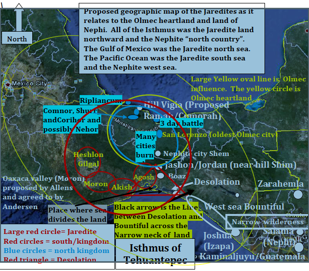
Some may suggest that a remote possibility would have been within the Maya mainly in the area of the Mirador Basin, Guatemala, where millions of Maya lived about that time period. However, the Maya in the Mirador Basin could not have been the Jaredite people described in the Book of Mormon. Even though they also had a written language, the Pre-classic Maya in the Peten were at their apex from about 300 BC to about 100 AD10, whereas the Olmec precipitously declined in population about 350 BC and ceased to be a recognizable culture by about 300 BC 11.
Not only do the Olmec fit the growth in population, decline in population, and the evidence of a written language, they also have settlements similar to the internal Jaredite map. By seeing the entire Isthmus of Tehuantepec as the Jaredite land northward from the north sea to the south sea instead of as the narrow neck of land, then it is possible to plausibly fit the rest of the Jaredite landmarks within this area coinciding with the Olmecs and early pre-classic Zapotec.
Dr. Richard Hauck is correct in his 1988 assessment that the “narrow neck of land” could not have been the Isthmus of Tehuantepec but that the “narrow neck of land” and the “place where the sea divides the land” were most likely located on the southeastern periphery of the Isthmus of Tehuantepec and on the Pacific coastal shelf (Hauck, 1988). The narrow neck of land that led into the land northward had to have been located southward of the land northward, or at least southward of the principal part of the land northward and within the southern part of the Isthmus of Tehuantepec. It would then follow that the Pacific Ocean would have been the Jaredite south sea/ Nephite west sea. Desolation would have bordered the Pacific Ocean as would the greater land of Moron to the west of Desolation. This configuration places Moron somewhere within the Oaxaca valley, which comprised the major Jaredite population in the southern part of the kingdom.
I want to emphasize that the Isthmus of Tehuantepec could not have been the narrow neck of land leading into the land northward because the entire isthmus was the Jaredite land northward from the south sea to the north sea. It was the narrow neck of the land bordering along the Pacific at the line between the land Desolation and west sea land Bountiful that led into the Isthmus of Tehuantepec, the Jaredite land northward.
10At its peak around 250 BC, the Maya built at least 27 large cities and countless smaller ones in the Petén. About 150 AD they suffered their first collapse as a society (AuthenticMaya:MayaCulture).
11 On the internet at Civilizations in America Richard Hooker states: “Around 300 BC, the Olmec vanished for reasons that vanished with them. We do know, however, that much of their culture and social structure was absorbed by other peoples
17
During the final civil war it appears that most of the Jaredites lived within the lower elevations surrounding and including the area of the Olmec heartland, which would have been the northern part of the Jaredite kingdom. I agree with Andrew Hedges who astutely describes this point in time as the place where a change in theatre occurred. After leaving the wilderness of Akish for the last time, the Jaredites never returned to the destroyed areas again, but instead continued northward to a more populated area (Hedges, 2009).
The Jaredite land northward, as described in the Book of Mormon, did not extend into the Mexico City area and probably not even into the Veracruz area. Apparently that last civil war did not extend northward from Ripliancum (Papaloapan Basin). Over 5 million people had been killed by the time the three battles on the hill Comnor had ended. Resources were dwindling and the soldiers and people were injured and weakened. It appears that at this time the war had covered the principal areas of the Jaredite populations and they were now ready to make their final stand at Ripliancum and then at Ramah. The sparse numbers and dwindling resources due to the burning of all the major cities would have made it nigh impossible to rebuild and start over elsewhere.
Despite the self-annihilation of the Jaredite people, there were still other people outside of the Jaredite kingdom lineage who inhabited and cultivated the surrounding area of the Isthmus of Tehuantepec. The book of Ether only records Jared’s lineage, but we know other families came to the promised land at the same time. The other people would have also exponentially increased their population over several generations and could have formed their own cultures in areas such as Abaj Takalik; Izapa; Pijijiapan; Ocos; Monte Alto etc. Some, from these families, could have eventually extended into southern Mesoamerica and northward past the Mexico City area. They could have been the foundational culture of the Mixtec people around Puebla. It is possible that some of these families migrated southward into the Yucatan area and mixed with the emerging Maya.
Concluding Thoughts
By corroborating Jaredite landmarks with the landmarks and locations mentioned throughout the rest of the Book of Mormon a reasonable theory of the approximate geographic locations of these landmarks can be established. The proposed maps, while not exact in
18
precision, will provide a guideline for further research and study of these areas. I believe that as we narrow our focus and search, our resources will best be used by focusing our efforts on the areas mentioned above.
Interestingly enough, a good friend of mine named Rolando Amado, president of the Archeological Research institute in Mesoamerica (ARIMA), agrees with Richard Hauck and me in an email in June 2011 where he says,
Joe: I don’t know if you have already located the only place in America where “the narrow neck of land, by the place where the sea divides the land…” does exists as a natural geographical and geological feature. Every time I was reading the B o M I asked myself where this particular place could be… In fact, as the B o M says and as you assume, this place is located in the land southward (west sea bountiful) of the proposed Jaredite area…It could be very interesting from the B o M archaeological point of view to find a great ancient city buried by this place. Some years ago, I was walking on this narrow neck of land, where the sea divides the land. I was trying to collect genealogical data from my paternal family. In fact this is the place where my paternal ancestors once lived. Check Google for satellite maps of Oaxaca, find Salina Cruz and go to the southeast. You will find this very place: the narrow neck of land and the place where the sea divides the land. All contained in a 100-120 km. landstrip.
While some may view this as simply anecdotal, I feel that additional authoritative authentication only gives further credence to a theory that is so fully supported by the weight of the Book of Mormon.
The many convergences of Book of Mormon locations and statements with geographical, archeological, and anthropological evidence, as shown in this article and others, confirm the Book of Mormon and its location in Mesoamerica. Joseph Smith also believed that the events of the Book of Mormon occurred in Central America. In 1842 the Prophet Joseph Smith gave his latest statements of his personal beliefs regarding the geography of the Book of Mormon. They are found in Times and Seasons, of which he was editor and manager and for which he had personally assumed complete responsibility. These statements confirm that, regardless of any prior statements he may have made, to the contrary notwithstanding, he believed, at the time of his death, that Central America was the location of the events recorded in the Book of Mormon. He explicitly states that the narrow neck of land is in fact located in Central America “…They lived about the narrow neck of land, which now embraces Central America, with all the cities that can be found…” (Times and Seasons, September 15, 1942). Joseph Smith additionally states, “…we have found another important fact relating to the truth of the Book of Mormon. Central America, or Guatemala, is situated north of the Isthmus of Darien and once embraced several hundred miles of territory from north to south. The city of Zarahemla stood upon this land…” (Times and Seasons, October 1, 1942). He concludes this new find with asserting its importance, “It is certainly a good thing for the excellency [sic] and veracity of the divine authenticity of the Book of Mormon, that the ruins of Zarahemla have been found…” While it is one thing to be able to establish the location with modern technology, it is quite another, some would even say revelatory, or Joseph Smith to have established the same thing during his time. Not only does the above theory rely on the Book of Mormon, it also aligns with the personal beliefs of Joseph Smith.
Some of the conclusions and speculations in this article, although interesting and probative, may, nonetheless, be susceptible to debate, which I certainly welcome and encourage. After all, we are all looking to establish the same thing: Where the Book of Mormon took place. I will openly concede to anyone whose argument is rooted in the Book of Mormon and discredits mine. However, there is one final conclusion that is absolute:
The “veracity and divine authenticity of the Book of Mormon” absolutely proves the reality and divinity of Jesus Christ.
Notes:
1 Coriantumr was a descendant of the brother of Jared (Ether 7:20 & 8:2, & 10:32 & 11:15).
2 See appendix A for a detailed chronology of the history of the Jaredite people.
3 See appendix A